Public Tags
Other tags: near:Ashington
Showing images tagged with place:Ashington tag.
|
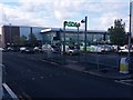
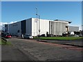
ASDA Supermarket, Ashington
by Graham Robson geograph for square NZ2787 A large ASDA supermarket on Lintonville Terrace in Ashington. The large modern... (more)
|
|
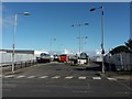
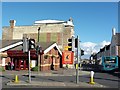
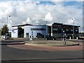
Ashington Bus Station
by Graham Robson geograph for square NZ2787 The current location of the temporary bus station in Ashington. In the last year... (more)
Tags:
place:Ashington
Bus StationX
top:Construction, DevelopmentX
type:GeographX
top:Roads, Road TransportX
|
|
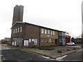
Former fire station, Ashington
by Graham Robson geograph for square NZ2587 The former fire station which was once the base for firefighters covering the... (more)
|
|
Ashington Bus Station
by Graham Robson geograph for square NZ2787 The bus station in Ashington. The area is currently at the start of a long term... (more)
|
|
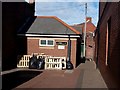
Public toilets, Station Road, Ashington
by Graham Robson geograph for square NZ2787 The small building housing public toilets of Station Road in Ashington.
|
|
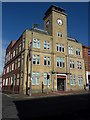
Ashington Town Hall
by Graham Robson geograph for square NZ2787 Ashington Town Hall on Station Road houses offices used by Northumberland County... (more)
|
|
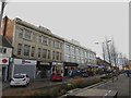
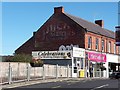
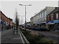
Shops, Station Road, Ashington
by Graham Robson geograph for square NZ2787 The most imposing buildings on Station Road, Ashington's main shopping... (more)
Tags:
place:Ashington
top:Business, Retail, ServicesX
type:GeographX
top:Roads, Road TransportX
Shopping StreetX
|
|
New paving, Ashington bus station
by Graham Robson geograph for square NZ2787 Work is under way laying a new road on part of the Portland Park site in... (more)
Tags:
place:Ashington
ConstructionX
top:Construction, DevelopmentX
type:GeographX
RoadX
top:Roads, Road TransportX
|
|
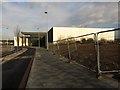
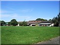
Ashington Leisure Centre
by Graham Robson geograph for square NZ2788 The new leisure centre is being built on the site of a former ASDA supermarket... (more)
Tags:
place:Ashington
Construction SiteX
top:Construction, DevelopmentX
Leisure CentreX
LibraryX
top:Public Buildings and SpacesX
top:Sport, LeisureX
|
|
Junction on Woodhorn Road, Ashington
by Graham Robson geograph for square NZ2787 A road junction on Woodhorn Road, Ashington. The road to the left is one of two... (more)
|
|
Poppies at Woodhorn Museum, Ashington
by Graham Robson geograph for square NZ2888 The "Weeping Window" on display at Woodhorn Museum, Ashington. The... (more)
|
|
Arriva bus depot, Ashington
by Graham Robson geograph for square NZ2788 The modern bus depot, home to Arriva North East's Ashington operation... (more)
|
|
Buildings on Station Road, Ashington
by Graham Robson geograph for square NZ2787 A row of terraced shops on Station Road Ashington. The gable of the 2 storey... (more)
Tags:
place:Ashington
top:Business, Retail, ServicesX
Ghost SignX
top:Historic Sites and ArtefactsX
Shopping StreetX
|
|
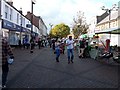
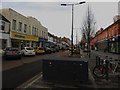
Station Road, Ashington
by Graham Robson geograph for square NZ2787 Looking along the pedestrianised shopping street in Ashington. The wide street... (more)
Tags:
place:Ashington
top:Business, Retail, ServicesX
Pedestrianised StreetX
top:Roads, Road TransportX
Shopping StreetX
|
|
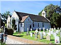
St Peter & St Paul Church, Ashington
by Paul Gillett geograph for square TQ1215 details: Link
|
|
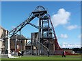
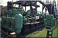
Woodhorn Colliery Museum, Ashington
by Chris Allen for square NZ2888 This location and view direction are best guesses as the current Google Maps... (more)
Tags:
place:Ashington
type:Close LookX
Former CollieryX
top:Historic Sites and ArtefactsX
MuseumX
subject:PumpX
top:Quarrying, MiningX
Woodhorn MuseumX
|
|
Station Road, Ashington
by Graham Robson geograph for square NZ2787 Looking east along the main shopping street in the centre of the town. In 2017... (more)
Tags:
place:Ashington
top:Business, Retail, ServicesX
type:GeographX
One-Way StreetX
top:Roads, Road TransportX
Shopping StreetX
|
|
Station Road, Ashington
by Graham Robson geograph for square NZ2787 The main shopping street in the centre of the town was altered in 2017 to... (more)
Tags:
place:Ashington
top:Business, Retail, ServicesX
type:GeographX
One-Way StreetX
top:Roads, Road TransportX
Shopping StreetX
|
|
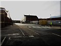
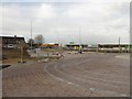
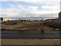
New road under construction, Portland Park, Ashington
by Graham Robson geograph for square NZ2787 Following several temporary moves the town's bus station has vacated this... (more)
Tags:
place:Ashington
top:City, Town CentreX
Construction SiteX
top:Construction, DevelopmentX
type:GeographX
New RoadX
|
|
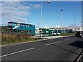
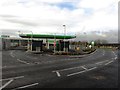
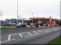
New ASDA petrol station, Ashington
by Graham Robson geograph for square NZ2787 In the 2nd half of 2017 the ASDA petrol station across the road from the main... (more)
Tags:
Asda Fuel Filling StationX
place:Ashington
top:Business, Retail, ServicesX
type:GeographX
Petrol StationX
|
|
New road, Portland Park, Ashington
by Graham Robson geograph for square NZ2787 As part of the redevelopment of land adjoining the town centre, which included... (more)
Tags:
place:Ashington
type:GeographX
New RoadX
top:Public Buildings and SpacesX
top:Roads, Road TransportX
|
|
Fuel filling station, Morpeth Road, Ashington
by Graham Robson geograph for square NZ2687 A fuel filling station selling petrol and diesel on Morpeth Road.
Tags:
place:Ashington
top:Business, Retail, ServicesX
Fuel Filling StationX
top:Roads, Road TransportX
|
|
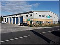
Arriva North East Depot, Ashington
by Graham Robson geograph for square NZ2788 The recently built depot where Arriva North East park and maintain their buses.... (more)
|
|
The Round House, Rotary Parkway, Ashington
by Graham Robson geograph for square NZ2788 The building is home to Age UK offices.
|
|
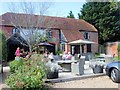
Red Lion Pub, Ashington
by Paul Gillett geograph for square TQ1315 |
|
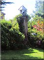
Dovecot, Sparrow Cottages, Ashington
by Paul Gillett geograph for square TQ1316 |
|
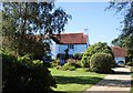
Sparrow Cottage, Ashington
by Paul Gillett geograph for square TQ1316 |
|
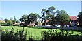
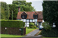
Cottages near Oast House farm
by Paul Gillett geograph for square TQ1316 On the edge of Ashington near the B2133
|
|
Ashington c of E School
by Paul Gillett geograph for square TQ1215 |
|
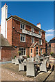
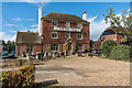
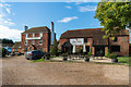
The Red Lion
by Ian Capper geograph for square TQ1315 18th Century grade II listed inn - see... (more)
Tags:
place:Ashington
top:Business, Retail, ServicesX
type:GeographX
Grade II ListedX
The Red LionX
top:Village, Rural SettlementX
|
|
The Red Lion
by Ian Capper geograph for square TQ1315 18th Century grade II listed inn - see... (more)
Tags:
place:Ashington
top:Business, Retail, ServicesX
type:GeographX
Grade II ListedX
The Red LionX
top:Village, Rural SettlementX
|
|
The Red Lion
by Ian Capper geograph for square TQ1315 18th Century grade II listed inn - see... (more)
Tags:
place:Ashington
top:Business, Retail, ServicesX
type:GeographX
Grade II ListedX
The Red LionX
top:Village, Rural SettlementX
|
|
The Red Lion
by Ian Capper geograph for square TQ1315 18th Century grade II listed inn - see... (more)
Tags:
place:Ashington
top:Business, Retail, ServicesX
type:GeographX
Grade II ListedX
The Red LionX
top:Village, Rural SettlementX
|
|
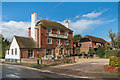
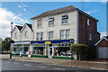
Clearview House
by Ian Capper geograph for square TQ1315 Building in London Road containing a pharmacy and a flooring retailer. The... (more)
Tags:
place:Ashington
top:Business, Retail, ServicesX
Clearview HouseX
type:GeographX
London RoadX
Post OfficeX
top:Village, Rural SettlementX
|
|
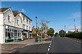
London Road
by Ian Capper geograph for square TQ1315 Looking north along London Road. On the left is Clearview House, containing a... (more)
Tags:
place:Ashington
top:Business, Retail, ServicesX
Clearview HouseX
type:GeographX
London RoadX
top:Village, Rural SettlementX
|
|
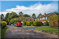
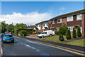
Mill Lane
by Ian Capper geograph for square TQ1315 1960s/70s housing. The 1974 1:2500 map calls this section of road Fairfield... (more)
Tags:
place:Ashington
Fairfield RoadX
type:GeographX
top:Housing, DwellingsX
Mill LaneX
top:Village, Rural SettlementX
|
|
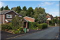
Willow Way
by Ian Capper geograph for square TQ1315 1970s estate off Mill Lane.
Tags:
place:Ashington
type:GeographX
top:Housing, DwellingsX
top:Village, Rural SettlementX
Willow WayX
|
|
The Willows
by Ian Capper geograph for square TQ1315 17th Century cottage in Willow Way. Grade II listed - see... (more)
Tags:
place:Ashington
type:GeographX
Grade II ListedX
top:Housing, DwellingsX
The WillowsX
top:Village, Rural SettlementX
Willow WayX
|
|
Mill Lane
by Ian Capper geograph for square TQ1315 1970s housing in what is shown on the 1974 1:2500 map as Red Lion Lane.
Tags:
place:Ashington
type:GeographX
top:Housing, DwellingsX
Mill LaneX
Red Lion LaneX
top:Village, Rural SettlementX
|