Public Tags
Other tags: near:Bideford
Showing latest 50 of 74 images tagged with place:Bideford tag.
|
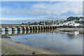
Bideford Long Bridge
by Ian Capper geograph for square SS4526 Bridge over the River Torridge, dating from the 14th or 15th Century (although... (more)
Tags:
place:Bideford
bridge:Bideford BridgeX
bridge:Bideford Long BridgeX
type:GeographX
Grade I ListedX
top:Rivers, Streams, DrainageX
top:Roads, Road TransportX
|
|
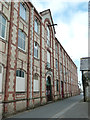
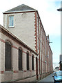
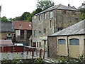
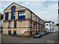
Former collar factory, Bideford
by Chris Allen geograph for square SS4526 A tall narrow building with ten bays each side of a central loading bay with... (more)
|
|
Former collar factory, Bideford
by Chris Allen geograph for square SS4526 This is behind the tyre centre and is a tall narrow building with ten bays each... (more)
Tags:
place:Bideford
Former FactoryX
type:GeographX
subject:Historic BuildingX
top:Historic Sites and ArtefactsX
|
|
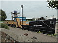
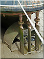
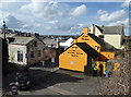
Diesel locomotive and brake van, Bideford
by Chris Allen for square SS4526 By the Bideford Railway Heritage Centre. The locomotive is Planet Locomotive No.... (more)
Tags:
place:Bideford
type:Close LookX
Diesel LocomotiveX
top:Historic Sites and ArtefactsX
Railway Heritage CentreX
subject:Railway LocomotiveX
top:RailwaysX
|
|
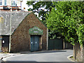
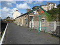
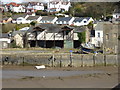
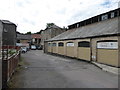
Port Manager's office, Bideford
by Chris Allen geograph for square SS4526 This building alongside the quay at Bideford houses the Port Manager's... (more)
|
|
Bideford Pottery Ropewalk Gallery, Bideford
by Chris Allen for square SS4526 Tags:
place:Bideford
top:Business, Retail, ServicesX
top:City, Town CentreX
type:Close LookX
subject:GalleryX
Pottery ShopX
|
|
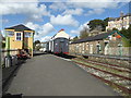
Bideford Railway Heritage Centre
by Chris Allen geograph for square SS4526 At the former Bideford Station on the Tarka Trail
Tags:
place:Bideford
type:GeographX
Heritage CentreX
top:Historic Sites and ArtefactsX
subject:Railway StationX
former:Railway StationX
top:RailwaysX
former:Station BuildingsX
Tarka TrailX
|
|
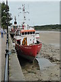
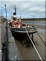
Bideford Quay
by Chris Allen geograph for square SS4527 The view from the car park includes the steam ship Freshspring that is being... (more)
Tags:
place:Bideford
type:GeographX
top:Historic Sites and ArtefactsX
Historical ShipX
Preserved SteamshipX
top:Rivers, Streams, DrainageX
subject:ShipX
river:TorridgeX
|
|
Former railway building Bideford
by Chris Allen geograph for square SS4527 This is the former carriage shed of the Bideford, Westward Ho! and Appledore... (more)
Tags:
place:Bideford
type:GeographX
subject:Railway BuildingX
former:Railway BuildingsX
top:RailwaysX
|
|
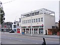
Bideford Post Office and neighbours, The Quay
by Robin Stott geograph for square SS4526 To its left, beside Ropewalk, is the long boathouse of the Bideford Amateur... (more)
Tags:
place:Bideford
top:Business, Retail, ServicesX
top:City, Town CentreX
top:CoastalX
postcode area:EX39X
region:North DevonX
Post OfficeX
|
|
Bideford Quakers
by Gordon Griffiths geograph for square SS4526 The view of Friends Meeting House in Honestone Street Bideford.
Tags:
place:Bideford
county:DevonX
Friends Meeting HouseX
subject:Meeting HouseX
QuakerX
top:Religious SitesX
|
|
Bideford Main Post Office
by Gordon Griffiths geograph for square SS4526 The view in Bideford on The Quay alongside the River Torridge.
Tags:
place:Bideford
top:City, Town CentreX
county:DevonX
subject:Post OfficeX
Post OfficeX
QuayX
river:TorridgeX
|
|
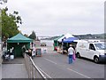
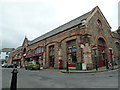
Bideford Market
by Gordon Griffiths geograph for square SS4526 The view of Bideford's Farmers Market on The Quay alongside the River Torridge.
|
|
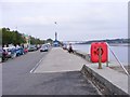
Bideford Quay
by Gordon Griffiths geograph for square SS4526 The view in Bideford along the River Torridge.
|
|
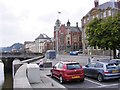
Bideford Scene
by Gordon Griffiths geograph for square SS4526 The view from Bideford's Quay towards the Town Hall.
|
|
Former collar factory, Bideford
by Chris Allen geograph for square SS4526 A tall narrow building with ten bays each side of a central loading bay with... (more)
|
|
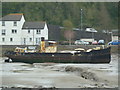
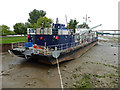
River Torridge, Bideford
by Chris Allen geograph for square SS4526 From The Quay. The former tender John Adams is in the centre. A motor vessel... (more)
Tags:
place:Bideford
top:Docks, HarboursX
top:Estuary, MarineX
Historic ShipX
top:Historic Sites and ArtefactsX
top:Rivers, Streams, DrainageX
river:TorridgeX
|
|
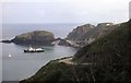
Our transport awaits - Lundy Island
by Martin Richard Phelan for square SS1443 At the end of my week long holiday on Lundy the Oldenburg waits in the bay to... (more)
Tags:
place:Bideford
subject:BoatX
type:Cross GridX
area:DevonX
top:Docks, HarboursX
top:Estuary, MarineX
top:IslandsX
place:LakeX
place:Lundy IslandX
Mv OldenburgX
area:North DevonX
top:Sport, LeisureX
top:Village, Rural SettlementX
|
|
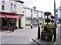
Market Place View
by Gordon Griffiths geograph for square SS4526 The view alongside Bideford's Pannier Market.
Tags:
place:Bideford
top:City, Town CentreX
county:DevonX
Indoor MarketX
subject:StreetX
Town StreetX
|
|
The two bus shelters at Fairy Cross
by David Smith geograph for square SS4024 This is where you catch a bus to Bude or Bideford, or Camelot, perhaps?
Tags:
place:Bideford
place:BudeX
Bus SheltersX
top:Roads, Road TransportX
Village Bus ShelterX
top:Village, Rural SettlementX
|
|
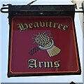
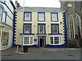
Sign: The Heavitree Arms
by John Myers for square SS4526 Bideford public house sign
Tags:
place:Bideford
top:Business, Retail, ServicesX
top:City, Town CentreX
type:Close LookX
top:CoastalX
Public HouseX
SignX
subject:SignX
|
|
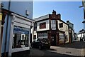
The Heavitree Arms
by John Myers geograph for square SS4526 Bideford public house
Tags:
place:Bideford
top:Business, Retail, ServicesX
top:City, Town CentreX
top:CoastalX
type:GeographX
subject:Public HouseX
Public HouseX
|
|
River Torridge and Quay, Bideford
by Chris Allen geograph for square SS4526 The A39 crosses over the bridge in the background.
|
|
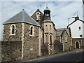
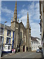
The Sacred Heart Catholic Church, Bideford
by Chris Allen geograph for square SS4526 |
|
Former collar factory, Bideford
by Chris Allen for square SS4426 A collection of buildings that formed a shirt collar manufactory and was later... (more)
Tags:
place:Bideford
type:Cross GridX
subject:FactoryX
Former FactoryX
top:Historic Sites and ArtefactsX
top:Suburb, Urban FringeX
|
|
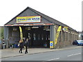
Northam Road, Bideford
by Chris Allen geograph for square SS4526 The building on the left is now Littlejohns Fireside - a fireplace shop.
Tags:
place:Bideford
subject:BusinessX
top:Business, Retail, ServicesX
type:GeographX
top:Suburb, Urban FringeX
|
|
Lavington United Reformed Church, Bideford
by Chris Allen geograph for square SS4526 On Bridgeland Street.
|
|
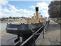
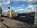
Steamship Freshspring, Bideford
by Chris Allen geograph for square SS4527 A preserved water carrier that has spent time at both Bristol and Newnham on... (more)
Tags:
place:Bideford
top:Docks, HarboursX
type:GeographX
Preserved SteamshipX
top:Rivers, Streams, DrainageX
subject:ShipX
river:TorridgeX
|
|
Bideford Railway Heritage Centre
by Chris Allen geograph for square SS4526 Alongside the Tarka Trail.
Tags:
place:Bideford
Former StationX
type:GeographX
top:Historic Sites and ArtefactsX
subject:MuseumX
top:PathsX
Railway Heritage CentreX
top:RailwaysX
Tarka TrailX
|
|
Tarka Trail, Bideford
by Chris Allen geograph for square SS4526 On the track bed of a former railway. The bridge crosses Station Hill.
|
|
North Road Chapel (Evangelical), Bideford
by Chris Allen geograph for square SS4526 |
|
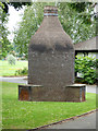
The Kiln in the Park, Bideford
by Chris Allen geograph for square SS4526 This replica bottle kiln is alongside The Burton Art Gallery and Museum in... (more)
|
|
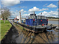
River Torridge at Kenwith Quay, Bideford
by Chris Allen geograph for square SS4527 The Long Bridge is seen in the background. The vessel in the foreground is MV... (more)
|
|
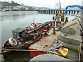
Kenwith Quay, Bideford
by Chris Allen for square SS4526 The vessel in the foreground is the MV Severn Sea. This is a research/survey... (more)
Tags:
place:Bideford
type:Close LookX
top:Docks, HarboursX
QuayX
subject:RiverX
top:Rivers, Streams, DrainageX
ShipX
river:TorridgeX
|
|
Barnstaple Street and Brunswick Wharf, Bideford
by Chris Allen geograph for square SS4526 My first stroll over the Long Bridge allowed me to photograph the former railway... (more)
|
|
Steamship Freshspring, Bideford
by Chris Allen geograph for square SS4527 A preserved water carrier that has spent time at both Bristol and Newnham on... (more)
Tags:
place:Bideford
type:GeographX
Historic ShipX
top:Historic Sites and ArtefactsX
subject:ShipX
Steam ShipX
river:TorridgeX
|
|
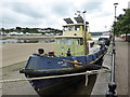
Bideford - Motor Tug Iona - details
by Chris Allen for square SS4527 Moored alongside is a rather rough motor tug named Ionia and built in 1959 by... (more)
Tags:
place:Bideford
Classic TugX
type:Close LookX
top:Docks, HarboursX
Motor TugX
subject:ShipX
river:TorridgeX
Tug BoatX
|
|
Bideford Quay and the River Torridge
by Chris Allen for square SS4527 Moored alongside is a rather rough motor tug named Ionia and built in 1959 by... (more)
Tags:
place:Bideford
Classic TugX
type:Cross GridX
Motor TugX
subject:RiverX
top:Rivers, Streams, DrainageX
river:TorridgeX
Tug BoatX
|
|
Bideford Pannier Market
by Chris Allen geograph for square SS4526 Tags:
place:Bideford
top:Business, Retail, ServicesX
top:City, Town CentreX
type:GeographX
subject:MarketX
|
|
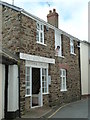
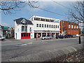
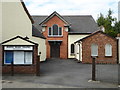
Citizens Advice Bureau, Bideford
by Chris Allen geograph for square SS4526 On Bridgeland Street.
Tags:
place:Bideford
subject:BuildingX
business:Citizens Advice BureauX
Citizens Advice BureauX
top:City, Town CentreX
type:GeographX
|
|
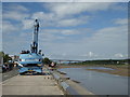
The River Torridge and Long Bridge, Bideford
by Chris Allen geograph for square SS4526 Seen from the car park alongside the quay. I am not sure what the blue excavator... (more)
|
|
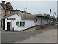
Cafe Onboard Ship, Bideford
by Chris Allen for square SS4527 Tags:
place:Bideford
top:Business, Retail, ServicesX
subject:CafeX
type:Close LookX
Floating CafeX
top:Rivers, Streams, DrainageX
river:TorridgeX
|
|
Cafe Onboard Ship, Bideford
by Chris Allen for square SS4527 A cafe and bar that floats on the tide. It was not floating when I saw it.
Tags:
place:Bideford
top:Business, Retail, ServicesX
subject:CafeX
type:Close LookX
Floating CafeX
top:Rivers, Streams, DrainageX
river:TorridgeX
|
|
Brunswick Wharf, Bideford
by Chris Allen geograph for square SS4526 Seen from the Long Bridge.
|
|
Brunswick Wharf, Bideford
by Chris Allen geograph for square SS4526 Seen across the River Torridge from near the Long Bridge.
|
|
The Blacksmith's Arms, Bideford
by Chris Allen geograph for square SS4526 Seen from the Tarka Trail along the bed of a disused railway.
Tags:
place:Bideford
top:Business, Retail, ServicesX
type:GeographX
top:PathsX
subject:Public HouseX
Tarka TrailX
|
|
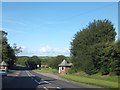
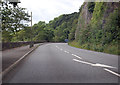
A386 south of Bideford
by J.Hannan-Briggs geograph for square SS4525 The road runs along the River Torridge for some miles.
|
|
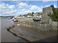
The Quay, Bideford
by J.Hannan-Briggs geograph for square SS4526 Heading south on A386.
|
|
Former collar factory - Bideford
by Chris Allen geograph for square SS4426 This part of this large former shirt collar factory is now a council depot for... (more)
|
|
Former collar factory - Bideford
by Chris Allen for square SS4426 A collection of buildings that formed a shirt collar manufactory and was later... (more)
|