Public Tags
Showing images tagged with place:Blawith tag.
|
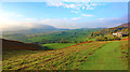
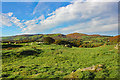
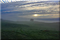
View across Tottlebank Farm
by Jeff Buck geograph for square SD2788 The view southwest across Tottlebank Farm near Blawith on an autumn morning.
|
|
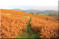
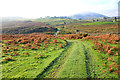
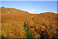
Track along The Low
by Jeff Buck geograph for square SD2788 Heading north along an area called The Low near Blawith.
|
|
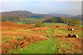
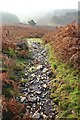
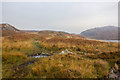
Track to Cockenskell
by Jeff Buck geograph for square SD2788 A slight diversion from the Cumbria Way takes us along a track north towards... (more)
|
|
Approaching Beacon Tarn
by Jeff Buck geograph for square SD2789 Heading north along the Cumbria Way towards Beacon Tarn. The Blawith Fells can... (more)
Tags:
place:Blawith
county:CumbriaX
Cumbria WayX
long distance footpath:Cumbria WayX
long distance path:Cumbria WayX
country:EnglandX
type:GeographX
Lake DistrictX
top:Lakes, Wetland, BogX
National ParkX
top:PathsX
TarnX
top:UplandsX
|
|
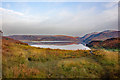
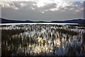
Beacon Tarn
by Jeff Buck for square SD2789 An autumn morning at Beacon Tarn near Blawith Fells.
Tags:
place:Blawith
type:Cross GridX
county:CumbriaX
country:EnglandX
Lake DistrictX
top:Lakes, Wetland, BogX
National ParkX
TarnX
top:UplandsX
|
|
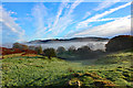
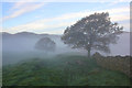
Mist in the valley below
by Jeff Buck geograph for square SD2887 Morning mist being slowly lifted by the sun near Ivy Tree south of Blawith.
|
|
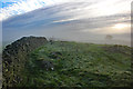
The Knotts
by Jeff Buck geograph for square SD2887 The mist has cleared leaving a beautiful sunny day on The Knotts near Blawith in Cumbria.
|
|
Cumbrian Dawn
by Jeff Buck geograph for square SD2887 Sunrise and mist on The Knotts near Blawith.
|
|
Sunrise over The Knotts
by Jeff Buck geograph for square SD2887 Dawn over The Knotts south of Blawith.
|
|
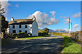
The A5084 at Little Knott
by Jeff Buck geograph for square SD2987 The A5084 beside the 18th century cottage of Little Knott as it heads north... (more)
|
|
The Cumbria Way at Tottlebank
by Jeff Buck geograph for square SD2787 Heading south along the Cumbria Way towards Gawthwaite from Tottlebank.
Tags:
place:Blawith
county:CumbriaX
long distance footpath:Cumbria WayX
long distance path:Cumbria WayX
Cumbria WayX
country:EnglandX
type:GeographX
Lake DistrictX
National ParkX
PathX
top:PathsX
TrackX
top:UplandsX
|
|
The Cumbria Way near Wool Knott
by Jeff Buck geograph for square SD2789 Heading south along the Cumbria Way near Wool Knott.
Tags:
place:Blawith
county:CumbriaX
Cumbria WayX
long distance footpath:Cumbria WayX
long distance path:Cumbria WayX
country:EnglandX
type:GeographX
Lake DistrictX
National ParkX
top:PathsX
top:UplandsX
|
|
The Cumbria Way at Wool Knott
by Jeff Buck geograph for square SD2789 Heading north along the Cumbria Way at Wool Knott towards Beacon Tarn.
Tags:
place:Blawith
county:CumbriaX
Cumbria WayX
long distance footpath:Cumbria WayX
long distance path:Cumbria WayX
country:EnglandX
type:GeographX
Lake DistrictX
National ParkX
top:PathsX
top:UplandsX
|
|
The Cumbria Way at Beacon Tarn
by Jeff Buck geograph for square SD2790 Heading north along a muddy stretch of the Cumbria Way next to Beacon Tarn.
Tags:
place:Blawith
county:CumbriaX
long distance footpath:Cumbria WayX
long distance path:Cumbria WayX
Cumbria WayX
country:EnglandX
type:GeographX
Lake DistrictX
National ParkX
top:PathsX
TarnX
top:UplandsX
|
|
Morning Mist on The Knotts
by Jeff Buck geograph for square SD2887 Morning mist on The Knotts near Blaworth, Cumbria.
|