Public Tags
Other tags: near:Cocklawburn
Showing images tagged with place:Cocklawburn tag.
|
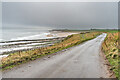
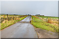
Lane along Cocklawburn Beach
by Ian Capper geograph for square NU0249 Lane running above Cocklawburn Beach, serving a number of parking areas for the... (more)
Tags:
BeachX
top:CoastalX
place:Cocklawburn
type:GeographX
place:Saltpan HowX
place:Saltpan RocksX
near:ScremerstonX
|
|
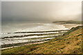
Saltpan Rocks and Cocklawburn Beach
by Ian Capper geograph for square NU0249 Looking across Saltpan Rocks towards Cocklawburn Beach under very low cloud.
|
|
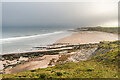
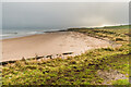
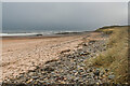
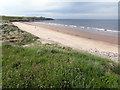
Cocklawburn Beach
by Ian Capper geograph for square NU0248 Looking along Cocklawburn Beach under low cloud. In the foreground is the start... (more)
|
|
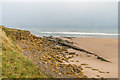
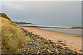
Cocklawburn Beach
by Ian Capper geograph for square NU0248 The northern end of Cocklawburn Beach with the start of Saltpan Rocks, seen here... (more)
|
|
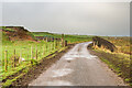
Lane to Cocklawburn Beach
by Ian Capper geograph for square NU0249 Looking back along the lane serving Cocklawburn Beach, with Sea House in the background.
|
|
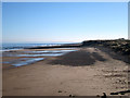
Cocklawburn Beach
by Ian Capper geograph for square NU0248 Looking along Cocklawburn Beach under low cloud.
|
|
Lane along Cocklawburn Beach
by Ian Capper geograph for square NU0248 Lane running above Cocklawburn Beach, serving a number of parking areas for the... (more)
|
|
Lane along Cocklawburn Beach
by Ian Capper geograph for square NU0248 Lane running above Cocklawburn Beach, serving a number of parking areas for the beach.
|
|
Cocklawburn Beach
by Ian Capper geograph for square NU0248 Looking along Cocklawburn Beach under low cloud.
|
|
Cocklawburn Beach
by Ian Capper geograph for square NU0248 Looking along Cocklawburn Beach under low cloud. In the left background is Sea House.
|

|
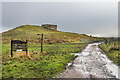
Lane along Cocklawburn Beach
by Ian Capper geograph for square NU0348 Lane running above Cocklawburn Beach, serving a number of parking areas for the... (more)
|
|
Saltpan Rocks, Cocklawburn
by Graham Robson for square NU0249 Looking across Saltpan Rocks at the northern end of Cocklawburn beach.
|
|
Looking along Cocklawburn beach
by Graham Robson geograph for square NU0248 Looking south along Cocklawburn beach towards Jocks Linn.
|
|
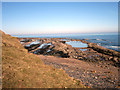
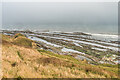
Saltpan Rocks
by Ian Capper geograph for square NU0249 Rock platform north of Cocklawburn Beach, seen here under low cloud. Note the... (more)
Tags:
top:CoastalX
place:Cocklawburn
type:GeographX
top:Geological InterestX
place:Saltpan RocksX
near:ScremerstonX
Whale BackX
Whale Back FoldX
|
|
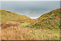
Cockley Burn
by Ian Capper geograph for square NU0248 The route of Cockley Burn through the dunes at Cocklawburn Beach, under low... (more)
Tags:
top:CoastalX
place:Cocklawburn
stream:Cockley BurnX
type:GeographX
top:Rivers, Streams, DrainageX
near:ScremerstonX
|
|
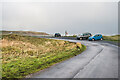
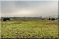
Cattle and Azuma
by Ian Capper geograph for square NU0348 Cattle in a field near the southern end of Cocklawburn Beach, with the sun... (more)
Tags:
train:AzumaX
top:CoastalX
place:Cocklawburn
railway:East Coast Main LineX
top:Farm, Fishery, Market GardeningX
type:GeographX
top:RailwaysX
near:ScremerstonX
|
|
Cocklawburn beach
by PAUL FARMER geograph for square NU0248 |
|
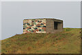
Scremerston Gun Emplacement
by Ian Capper geograph for square NU0348 WWII Gun Emplacement built on the site of the lime kiln battery of the former... (more)
Tags:
top:CoastalX
place:Cocklawburn
top:Defence, MilitaryX
type:GeographX
Gun EmplacementX
top:PathsX
Pill BoxX
near:ScremerstonX
|
|
Scremerston Gun Emplacement
by Ian Capper for square NU0348 WWII Gun Emplacement built on the site of the lime kiln battery of the former... (more)
Tags:
near:CheswickX
type:Close LookX
top:CoastalX
place:Cocklawburn
top:Defence, MilitaryX
Gun EmplacementX
Pill BoxX
near:ScremerstonX
|
|
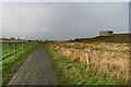
North of Cheswick
by Ian Capper geograph for square NU0348 The coast path running behind the dunes north of Cheswick. In the right... (more)
Tags:
near:CheswickX
top:CoastalX
place:Cocklawburn
type:GeographX
Gun EmplacementX
top:PathsX
Pill BoxX
near:ScremerstonX
|