Public Tags
Showing images tagged with place:Corbridge tag.
|
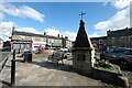
Corbridge Pant and Market Place
by Jeff Buck geograph for square NY9864 In parts of Scotland and northern England the 'pant' was a public... (more)
Tags:
place:Corbridge
country:EnglandX
type:GeographX
Market PlaceX
Market SquareX
county:NorthumberlandX
top:Village, Rural SettlementX
|
|
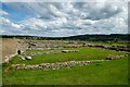
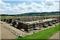
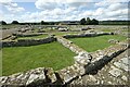
Roman Corbridge (Coria)
by Jeff Buck geograph for square NY9864 Overlooking the west compound of Coria (Roman Corbridge).
Wikipedia Coria... (more)
Tags:
place:Corbridge
country:EnglandX
English HeritageX
English Heritage PropertyX
FortX
type:GeographX
top:Historic Sites and ArtefactsX
county:NorthumberlandX
Roman CorbridgeX
Roman FortX
|
|
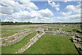
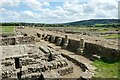
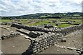
The Granaries at Coria (Corbridge)
by Jeff Buck geograph for square NY9864 The granaries at Roman Corbridge (Coria).
Wikipedia Coria (Corbridge)... (more)
Tags:
place:Corbridge
country:EnglandX
English HeritageX
English Heritage PropertyX
FortX
type:GeographX
GranariesX
top:Historic Sites and ArtefactsX
county:NorthumberlandX
Roman FortX
|
|
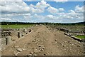
The Stanegate at Coria (Corbridge)
by Jeff Buck geograph for square NY9864 Roman Corbridge (Coria) commanded the junction of two main Roman roads, Dere... (more)
Tags:
place:Corbridge
country:EnglandX
English HeritageX
English Heritage PropertyX
FortX
type:GeographX
top:Historic Sites and ArtefactsX
county:NorthumberlandX
Roman FortX
Roman RoadX
|
|
Coria (Corbridge)
by Jeff Buck geograph for square NY9864 Part of the granaries next to the 'Stanegate' at Roman Corbridge.... (more)
Tags:
place:Corbridge
country:EnglandX
English HeritageX
English Heritage PropertyX
FortX
type:GeographX
GranariesX
top:Historic Sites and ArtefactsX
county:NorthumberlandX
Roman FortX
|
|
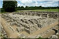
Roman Corbridge (Coria)
by Jeff Buck geograph for square NY9864 In the west compound of Coria.
Wikipedia Coria (Corbridge)... (more)
Tags:
place:Corbridge
country:EnglandX
English HeritageX
English Heritage PropertyX
FortX
type:GeographX
top:Historic Sites and ArtefactsX
county:NorthumberlandX
Roman FortX
|
|
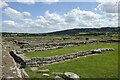
Roman Corbridge (Coria)
by Jeff Buck geograph for square NY9864 Buildings in the east compound of Coria.
Wikipedia Coria (Corbridge)... (more)
Tags:
place:Corbridge
country:EnglandX
English HeritageX
English Heritage PropertyX
FortX
type:GeographX
top:Historic Sites and ArtefactsX
county:NorthumberlandX
Roman FortX
|
|
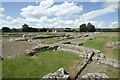
Coria (Corbridge)
by Jeff Buck geograph for square NY9864 Buildings in the eastern part of Coria.
Wikipedia Coria (Corbridge)... (more)
Tags:
place:Corbridge
country:EnglandX
English HeritageX
English Heritage PropertyX
FortX
type:GeographX
top:Historic Sites and ArtefactsX
county:NorthumberlandX
Roman FortX
|
|
Coria (Corbridge)
by Jeff Buck geograph for square NY9864 Area of civilian buildings and shops next to the 'Stanegate' at Coria.... (more)
Tags:
place:Corbridge
country:EnglandX
English HeritageX
English Heritage PropertyX
FortX
type:GeographX
top:Historic Sites and ArtefactsX
county:NorthumberlandX
Roman FortX
|
|
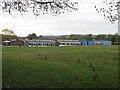
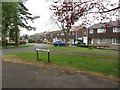
Corbridge First School
by Graham Robson geograph for square NY9964 Looking across the playing field towards the school buildings of Corbridge First School.
|
|
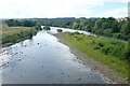
The River Tyne at Corbridge
by Jeff Buck geograph for square NY9864 The view west from Corbridge Bridge along the River Tyne.
|
|
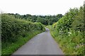
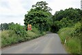
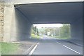
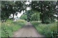
Leazes Lane near Corbridge
by Jeff Buck geograph for square NY9965 Heading downhill along Leazes Lane before it passes under the A68 and enters Corbridge.
|
|
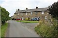
Glebelands, Corbridge
by Graham Robson geograph for square NY9964 A quiet residential street in the small town of Corbridge.
Tags:
place:Corbridge
type:GeographX
HousesX
top:Housing, DwellingsX
Residential StreetX
top:Roads, Road TransportX
|
|
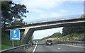
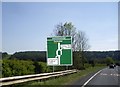
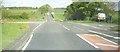
Approach to Styford Roundabout from Corbridge (B6530)
by Stanley Howe geograph for square NZ0263 Junction of A69 (to Newcastle) with A68 (to Darlington).
|
|
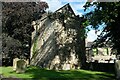
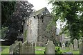
Corbridge Vicar's Pele
by Jeff Buck geograph for square NY9864 The Vicar's Pele was built in 1318 in the churchyard of St Andrew's... (more)
Tags:
place:Corbridge
country:EnglandX
Events VenueX
type:GeographX
top:Historic Sites and ArtefactsX
county:NorthumberlandX
Pele TowerX
top:Religious SitesX
Wedding VenueX
|
|
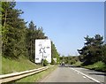
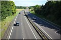
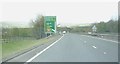
The A69 at Thornbrough
by Jeff Buck geograph for square NZ0164 The A69 at Thornbrough near Corbridge.
Tags:
road:A69X
A69X
place:Corbridge
Dual CarriagewayX
country:EnglandX
type:GeographX
county:NorthumberlandX
top:Roads, Road TransportX
|
|
Footpath to Brockhole Wood
by Jeff Buck geograph for square NZ0164 Footpath heading northeast towards Brockhole Wood at Thornbrough near Corbridge.
|
|
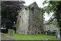
The Vicar's Pele, Corbridge
by Jeff Buck geograph for square NY9864 The Vicar's Pele was built in 1318 in the churchyard of St Andrew's... (more)
Tags:
place:Corbridge
country:EnglandX
Events VenueX
type:GeographX
top:Historic Sites and ArtefactsX
county:NorthumberlandX
Pele TowerX
Wedding VenueX
|
|
The Vicar's Pele, Corbridge
by Jeff Buck geograph for square NY9864 The Vicar's Pele was built in 1318 in the churchyard of St Andrew's... (more)
Tags:
ChurchyardX
place:Corbridge
country:EnglandX
Events VenueX
type:GeographX
top:Historic Sites and ArtefactsX
county:NorthumberlandX
Pele TowerX
Wedding VenueX
|
|
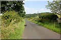
Corchester Lane
by Jeff Buck geograph for square NY9765 Looking west along Corchester Lane near Corbridge.
|
|
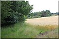
View across the fields from Corchester Lane
by Jeff Buck geograph for square NY9765 Looking north across the fields from Corchester Lane near Corbridge.
|
|
Lane next to Hampstead House
by Jeff Buck geograph for square NY9865 Looking northwest along a lane next to Hampstead House near Corbridge.
|
|
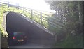
Underpass of A68 under A69
by Stanley Howe geograph for square NY9865 North of Corbridge.
|
|
Aydon Road (B6321) over the A68/A69 near Gallow Hill
by Stanley Howe geograph for square NZ0065 On the section of the A69 shared with the A68 as it wends north near Corbridge.
|
|
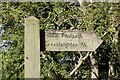
Public Footpath Sign to Greenleighton
by Jeff Buck for square NZ0266 3/4 of a mile to Greenleighton.
Tags:
type:Close LookX
place:Corbridge
country:EnglandX
Footpath SignX
county:NorthumberlandX
top:PathsX
Public FootpathX
Public Right of WayX
|
|
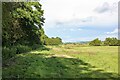
Public footpath to Greenleighton
by Jeff Buck geograph for square NZ0266 Public footpath heading east to Greenleighton. Brockhole Burn runs alongside on the left.
|
|
Track to Codlaw Hill
by Jeff Buck geograph for square NY9567 Marked on the OS map as an on-road cycle route.
Tags:
place:Corbridge
country:EnglandX
type:GeographX
LaneX
county:NorthumberlandX
On-Road Cycle RouteX
PathX
top:PathsX
Public FootpathX
Public Right of WayX
|
|
Beaufront Wood Head Farm
by Jeff Buck geograph for square NY9566 Buildings at Beaufront Wood Head Farm.
|
|
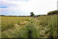
Footpath to Anick
by Jeff Buck geograph for square NY9665 Footpath heading southwest towards Anick.
Tags:
place:Corbridge
country:EnglandX
type:GeographX
county:NorthumberlandX
PathX
top:PathsX
Public FootpathX
Public Right of WayX
|
|
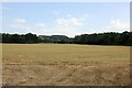
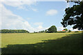
Farmland near Stagshaw House
by Jeff Buck geograph for square NY9866 Looking northwest across the fields. Buildings around Holly Hall can be seen on the right.
|
|
Approach to Broomhaugh roundabout
by Stanley Howe geograph for square NZ0361 On the A68 near Styford Bridge over the River Tyne.
|
|
A69 underpass
by Stanley Howe geograph for square NZ0263 One-way exit for cars visiting Brocks Bushes farm shop; but beware the... (more)
|
|
Bird droppings!
by Stanley Howe for square NZ0263 Various ova on offer (singly or by half dozens) at the Brocks Bushes farm shop.
|
|
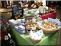
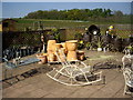
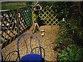
Garden ornaments for sale
by Stanley Howe geograph for square NZ0263 At Brocksbushes farm shop.
|
|
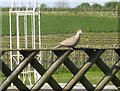
Collared Doves at Brocksbushes
by Stanley Howe for square NZ0263 Beneath a bird feeder table - one foraging, the other sun bathing.
|
|
Collared Dove at Brocksbushes
by Stanley Howe for square NZ0263 Outside the tea shop.
|
|
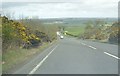
Approaching junction for Bingfield
by Stanley Howe geograph for square NY9771 Now visible early, thanks to a cutting on the A68 (Dere Street) which removed... (more)
|
|
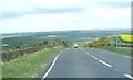
North along Dere Street
by Stanley Howe geograph for square NY9771 The line of the Roman Road can be seen stretching ahead in a 'lang stracht'.
|
|
A6079 junction with A68
by Stanley Howe geograph for square NY9574 To Hexham via Chollerford; Wallington off right.
|
|
Near the line of Hadrian's Wall
by Stanley Howe geograph for square NY9868 The A68 passes through what was the site of the Romans' 'Port... (more)
|
|
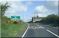
Approach to Stagshaw Road junction (A68/A69)
by Stanley Howe geograph for square NY9965 Stagshaw Bank (A68) is a straight Roman Road that crosses the line of... (more)
|
|
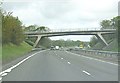
The Thornbrough bridge over the A69
by Stanley Howe geograph for square NZ0164 Over a stretch of the A69 which links two sections of the A68 (Darlington to... (more)
|