Public Tags
Showing images tagged with place:Cornhill tag.
|
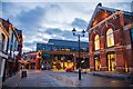
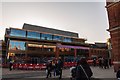
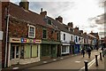
Cornhill Development, Lincoln
by Oliver Mills geograph for square SK9771 Viewed from Sincil Street. Developments include the refurbishment of the Corn... (more)
Tags:
top:Business, Retail, ServicesX
subject:CinemaX
top:City, Town CentreX
Corn ExchangeX
place:Cornhill
type:GeographX
place:LincolnX
top:Public Buildings and SpacesX
top:Roads, Road TransportX
subject:ShopX
|
|
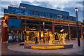
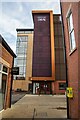
Cornhill Development, Lincoln
by Oliver Mills geograph for square SK9771 Taken in the early evening, showing the new "Everyman" cinema and... (more)
Tags:
top:Business, Retail, ServicesX
Christmas LightsX
subject:CinemaX
top:City, Town CentreX
Corn ExchangeX
place:Cornhill
cinema:EverymanX
type:GeographX
place:LincolnX
top:Public Buildings and SpacesX
|
|
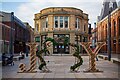
Joy at the Cornhill Quarter, Lincoln
by Oliver Mills geograph for square SK9771 Part of the Christmas decorations; the entire area looks very attractive in the evening.
Tags:
top:Business, Retail, ServicesX
Christmas DecorationsX
Christmas LightsX
top:City, Town CentreX
Corn ExchangeX
place:Cornhill
type:GeographX
place:LincolnX
top:Public Buildings and SpacesX
subject:ShopX
|
|
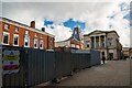
Former site of the Cornhill Kiosk, Lincoln
by Oliver Mills geograph for square SK9771 Behind the hoarding panels used to be a Victorian-styled shelter, originally... (more)
Tags:
top:City, Town CentreX
Corn ExchangeX
place:Cornhill
DemolitionX
subject:Demolition SiteX
type:GeographX
top:Historic Sites and ArtefactsX
subject:KioskX
place:LincolnX
top:PathsX
top:Public Buildings and SpacesX
|
|
Cornhill Development, Lincoln
by Oliver Mills geograph for square SK9771 A new retail development, under construction. It looks somewhat generic and... (more)
Tags:
top:Business, Retail, ServicesX
place:Cornhill
type:GeographX
place:LincolnX
Retail DevelopmentX
|
|
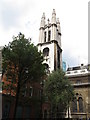
Spire of St. Michael's Cornhill
by Roger Jones for square TQ3281 See: Link
Tags:
ChurchX
Church SpireX
place:City of LondonX
top:City, Town CentreX
place:Cornhill
top:Religious SitesX
|
|
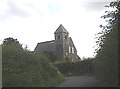
St Paul's Church, Branxton
by Stanley Howe geograph for square NT8937 Seen off the minor road from Cornhill-on-Tweed.
|
|
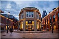
The Corn Exchange, Lincoln
by Oliver Mills geograph for square SK9771 The first Corn Exchange is located centrally, the second is located on the... (more)
Tags:
top:City, Town CentreX
Corn ExchangeX
place:Cornhill
type:GeographX
place:LincolnX
top:Public Buildings and SpacesX
subject:ShopX
|
|
Sincil Street, Lincoln
by Oliver Mills geograph for square SK9771 |
|
Lincoln Central Car Park
by Oliver Mills geograph for square SK9771 Built on the site of the former bus station, the entire area has been entirely... (more)
|
|
Redscar Bridge
by Stanley Howe geograph for square NT9433 Over the River Till.
Tags:
place:Cornhill
Minor RoadX
top:Rivers, Streams, DrainageX
Road Bridge Over RiverX
top:Roads, Road TransportX
river:TillX
|
|
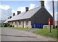
Terraced farmworkers cottages near Kimmerston
by Stanley Howe geograph for square NT9535 With their own pillar-mounted rural postbox.
|
|
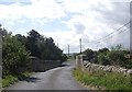
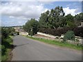
Minor road past Kimmerston
by Stanley Howe geograph for square NT9535 Down to West Kimmerston Bridge, and on to Ford Castle.
|
|
Kimmerston Farmhouse name sign
by Stanley Howe for square NT9535 Announcing the farm's herd of pedigree Dexters,... (more)
|
|
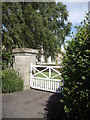
Entrance to Kimmerston Farmhouse
by Stanley Howe geograph for square NT9535 Wooden gate; stone gatepost.
|
|
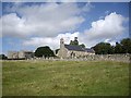
Parson's Tower and Church, Ford Castle
by Stanley Howe geograph for square NT9437 In the grounds of Ford Castle (can be glimpsed behind the church in centre... (more)
|
|
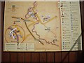
Ford Etal Estates map
by Stanley Howe for square NT9338 On the Railway Booking office at Heatherslaw.
|
|
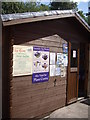
Heatherslaw Station booking office
by Stanley Howe for square NT9338 |
|
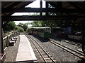
Heatherslaw Station; platform and rolling stock
by Stanley Howe geograph for square NT9338 A terminus on the Heatherslaw Light Railway.
|
|
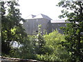
Heatherslaw Mill
by Stanley Howe geograph for square NT9338 Seen across the River Till, from Heatherslaw Station.
|
|
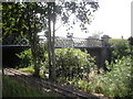
Heatherslaw Bridge over the River Till
by Stanley Howe geograph for square NT9338 Seen from Heatherslaw Mill car park. Heatherslaw Light Railway track in the... (more)
|
|
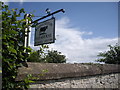
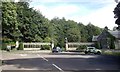
West lodge, Ford Castle
by Stanley Howe geograph for square NT9337 Off B6354 at its intersection with B6353.
Tags:
road:B6353X
road:B6354X
place:Cornhill
top:Country EstatesX
Gatehouse LodgeX
Junction of B Classified RoadsX
|
|
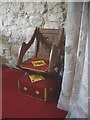
A carved wood chair in Branxton Church
by Stanley Howe for square NT8937 A minister's chair with hassock.
|
|
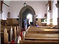
Branxton Church interior
by Stanley Howe for square NT8937 |
|
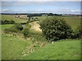
Minor road to Branxton Buildings
by Stanley Howe geograph for square NT8937 Seen from the old graveyard of Branxton Church.
|
|
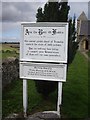
An information notice, Branxton Church
by Stanley Howe geograph for square NT8937 Recalling that The slain of both nations were brought here after the battle of... (more)
|
|
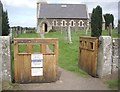
Gated entrance to Branxton Church old graveyard
by Stanley Howe geograph for square NT8937 An newer graveyard has been opened on the opposite side of this minor road, with... (more)
|
|
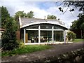
A cottage with a conservatory, Branxton
by Stanley Howe geograph for square NT8937 Adjacent to Branxton Church; the conservatory of an unusual design.
|
|
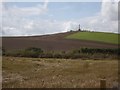
View towards Floddon Field battle monument
by Stanley Howe geograph for square NT8937 On Stock Law; viewed here from the car park of Branxton Church across farmed fields.
|