Public Tags
Other tags: Cotebrook
Showing images tagged with place:Cotebrook tag.
|
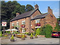
The Alvanley Arms, Cotebrook
by Jeff Buck geograph for square SJ5765 The Alvanley Arms is a 400 year old Coaching Inn located next to the Cotebrook... (more)
Tags:
top:Business, Retail, ServicesX
county:CheshireX
place:Cotebrook
country:EnglandX
PubX
subject:Public HouseX
Public House and RestaurantX
|
|
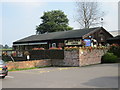
Cotebrook Shire Horse Centre & Countryside Park
by Jeff Buck geograph for square SJ5765 The entrance to the Shire Horse Centre. Cotebrook Shire Horse Centre &... (more)
Tags:
subject:AttractionX
top:Business, Retail, ServicesX
county:CheshireX
place:Cotebrook
country:EnglandX
Shire Horse CentreX
StudX
top:Village, Rural SettlementX
|
|
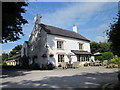
The Fox and Barrel at Cotebrook
by Jeff Buck geograph for square SJ5765 The Fox and Barrel is a traditional pub on the A49 at Cotebrook.
Tags:
top:Business, Retail, ServicesX
county:CheshireX
place:Cotebrook
country:EnglandX
PubX
subject:Public HouseX
Public HouseX
top:Village, Rural SettlementX
|
|
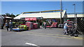
Tarporley Garden Centre
by Jeff Buck geograph for square SJ5766 Tarporley Garden Centre located on the A49 north of the village of Tarporley at Cotebrook.
|
|
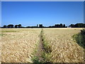
Footpath to Brownhill
by Jeff Buck geograph for square SJ5764 Footpath connecting Beech Lane and Brownhills Road near Cotebrook.
|
|
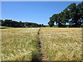
Footpath to Eaton Lane
by Jeff Buck geograph for square SJ5764 Footpath connecting Beech Lane and Eaton Lane near Cotebrook.
|
|
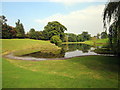
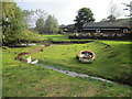
Pond at the Cotebrook Shire Horse Centre
by Jeff Buck geograph for square SJ5765 Taken from the Alvanley Arms beer garden.
|
|
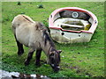
Shetland Pony and Boat
by Jeff Buck for square SJ5765 A Shetland pony at the Cotebrook Shire Horse Centre.
Tags:
top:Business, Retail, ServicesX
county:CheshireX
place:Cotebrook
country:EnglandX
subject:PonyX
Shetland PonyX
Shire Horse CentreX
|
|
Cotebrook Shire Horse Centre
by Jeff Buck geograph for square SJ5765 Taken from the Alvanley Arms beer garden.
Tags:
subject:AttractionX
top:Business, Retail, ServicesX
county:CheshireX
place:Cotebrook
country:EnglandX
top:Rivers, Streams, DrainageX
Shire Horse CentreX
StudX
|
|
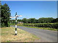
Lane Junction at Brownhill
by Jeff Buck geograph for square SJ5764 At the junction of three Lanes - Oulton Mill Lane, Brownhills Road and Beech Lane.
|