Geograph - photograph every grid square
About tags on Geograph
Tags
Geographical Context
Subjects
Types
Other Prefixes
Public Tags
Related Tags
|
Coverage Map
Prefix:
place
Tag:
Hope·Bowdler
Showing images tagged with
place:
Hope Bowdler
tag.
View all tagged images
-
In Browser
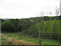
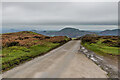
In sight of Hope - Hope Bowdler, Shropshire
by
Martin Richard Phelan
geograph for square
SO4792
A view of the village of Hope Bowdler from the bridleway leading from the... (
more
)
Tags:
B4371
X
Bridleway
X
Church Stretton to Much Wenlock Road
X
top:
Grassland
X
place:
Hope Bowdler
place:
Hope Bowdler Hill
X
top:
Housing, Dwellings
X
top:
Lowlands
X
top:
Paths
X
Public Right of Way
X
place:
Shropshire
X
place:
South Shropshire
X
top:
Sport, Leisure
X
top:
Village, Rural Settlement
X
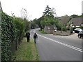
Back again in Hope - Hope Bowdler, Shropshire
by
Martin Richard Phelan
geograph for square
SO4792
Walking beside the B4371 Church Stretton to Much Wenlock road in Hope Bowdler... (
more
)
Tags:
B Road
X
B4371
X
Church Stretton to Much Wenlock Road
X
top:
Grassland
X
place:
Hope Bowdler
place:
Hope Bowdler Hill
X
top:
Lowlands
X
Public Road
X
top:
Roads, Road Transport
X
place:
Shropshire
X
place:
South Shropshire
X
top:
Sport, Leisure
X
top:
Village, Rural Settlement
X
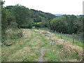
Bridleway to Hope - Hope Bowdler, Shropshire
by
Martin Richard Phelan
geograph for square
SO4792
Another view of the bridleway leading from Hope Bowdler Hill to the B4371... (
more
)
Tags:
B4371
X
Bridleway
X
Church Stretton to Much Wenlock Road
X
top:
Grassland
X
place:
Hope Bowdler
place:
Hope Bowdler Hill
X
top:
Lowlands
X
top:
Paths
X
Public Right of Way
X
place:
Shropshire
X
place:
South Shropshire
X
top:
Sport, Leisure
X
top:
Village, Rural Settlement
X
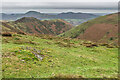
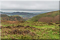
Above Townbrook Valley
by
Ian Capper
geograph for square
SO4393
Rough grassland with patches of heather above Townbrook Valley on the Long Mynd... (
more
)
Tags:
place:
Burway Hill
X
place:
Caer Caradoc
X
near:
Church Stretton
X
type:
Geograph
X
place:
Hope Bowdler
place:
Hope Bowdler Hill
X
place:
Long Mynd
X
place:
Townbrook Valley
X
top:
Uplands
X
The Burway
by
Ian Capper
geograph for square
SO4394
Road connecting Church Stretton with the summit plateau of the Long Mynd. In... (
more
)
Tags:
place:
Caer Caradoc
X
near:
Church Stretton
X
type:
Geograph
X
place:
Hope Bowdler
place:
Hope Bowdler Hill
X
place:
Long Mynd
X
top:
Roads, Road Transport
X
road:
The Burway
X
place:
The Lawley
X
place:
The Wrekin
X
top:
Uplands
X
Above Townbrook Valley
by
Ian Capper
geograph for square
SO4394
Rough grassland with patches of bracken and heather above Townbrook Valley on... (
more
)
Tags:
near:
Church Stretton
X
type:
Geograph
X
place:
Hope Bowdler
place:
Hope Bowdler Hill
X
place:
Long Mynd
X
place:
Townbrook Valley
X
top:
Uplands
X
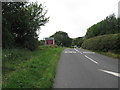
A sign of the times - Hope Bowdler, Shropshire
by
Martin Richard Phelan
geograph for square
SO4792
Signs like these, with modern traffic speeds, are now quite a common sight in... (
more
)
Tags:
B Road
X
B4371
X
Church Stretton to Much Wenlock Road
X
top:
Grassland
X
place:
Hope Bowdler
place:
Hope Bowdler Hill
X
top:
Lowlands
X
Public Road
X
top:
Roads, Road Transport
X
place:
Shropshire
X
place:
South Shropshire
X
Speed Limit Sign
X
top:
Sport, Leisure
X
Village Name Sign
X
top:
Village, Rural Settlement
X
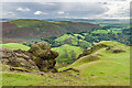
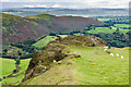
Caer Caradoc
by
Ian Capper
geograph for square
SO4795
Rock outcrop near the summit of Caer Caradoc with Hope Bowdler in the background.
Tags:
place:
Caer Caradoc
X
near:
Church Stretton
X
type:
Geograph
X
place:
Hope Bowdler
place:
Hope Bowlder
X
top:
Uplands
X
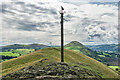
Weather vane, The Lawley
by
Ian Capper
geograph for square
SO4997
Weather vane depicting a Raven on the summit of The Lawley with Caer Caradoc... (
more
)
Tags:
place:
Caer Caradoc
X
type:
Geograph
X
place:
Hope Bowdler
place:
The Lawley
X
top:
Uplands
X
Weather Vane
X
Caer Caradoc
by
Ian Capper
geograph for square
SO4795
Rock outcrop near the summit of Caer Caradoc with Hope Bowdler in the background.
Tags:
place:
Caer Caradoc
X
near:
Church Stretton
X
type:
Geograph
X
place:
Hope Bowdler
top:
Uplands
X
View more in the Image Search
or
in Browser
View images matching 'Hope Bowdler' anywhere
in
the tags
Don't click these:
PotMel 1
PotMel 2
☰
Home
View
Search
Marked Images
Maps
Browser
Explore
Showcase
New Images
Collections
Interact
Games
Discussions
Blog
Contributors
Submit
Statistics
Leaderboards
General
FAQ
Help Pages
Sitemap
Contact Us
Support Us
sponsored by
🔍
What to search:
Photos
Enter keywords or a location/postcode to search nearby images
Enter a Grid Reference
Placenames
Collections
Website Pages
Everything
Others:
Advanced Search
|
Image Browser
Or:
Coverage Map
|
Searchable Map
You are not logged in
login
|
register