|
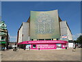
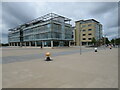
The Deep, Hull
by Malc McDonald
geograph for square TA1028
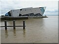
The Deep is an aquarium in Hull, which opened in 2002. It stands at the... (more)
|
|
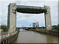
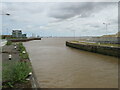
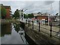
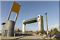
River Hull tidal surge barrier, Hull
by Malc McDonald
geograph for square TA1028
|
|
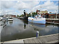
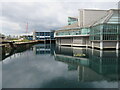
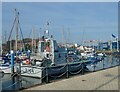
Hull Marina
by Malc McDonald
geograph for square TA0928
Boats moored in Hull Marina, which occupies the former Humber Dock. The black... (more)
|
|
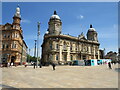
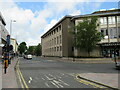
Queen Victoria Square, Hull
by Malc McDonald
geograph for square TA0928
The building in the centre of the image is Hull Maritime Museum.
|
|
Albert dock entrance and Humber Estuary, Hull
by Malc McDonald
geograph for square TA0927
The entrance channel to Hull's Albert Dock, looking out to the Humber estuary.
|
|
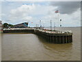
Minerva Pier, Hull
by Malc McDonald
geograph for square TA0928
Minerva Pier protects the entrance to Hull's Humber Dock Basin, on the... (more)
|

|
Humber Dock and footbridge over Castle Street, Hull
by Malc McDonald
geograph for square TA0928
The bridge in the background is a footbridge over the A63 as it passes to the... (more)
|
|
Trans Pennine Trail, Hull
by Malc McDonald
geograph for square TA0928
This path through Hull's docks forms part of the walking route of the Trans... (more)
|
|
Wellington Street West, Hull
by Malc McDonald
geograph for square TA0928
Wellington Street West, in Hull's former docklands. The houses on the... (more)
|
|
Wellington Street West, Hull
by Malc McDonald
geograph for square TA0928
Wellington Street West in Hull's former docklands. The rails still... (more)
|
|
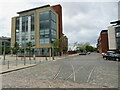
Humber Quays office block, Hull
by Malc McDonald
geograph for square TA0928
An office block at Humber Quays in Hull. This site used to be part of... (more)
|
|
Prince's Quay, Hull
by Malc McDonald
geograph for square TA0928
The former Prince's Dock in Hull. The Prince's Quay shopping centre... (more)
|
|
Prince's Quay, Hull
by Malc McDonald
geograph for square TA0928
The former Prince's Dock in Hull. The Prince's Quay shopping centre... (more)
|
|
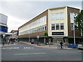
Former BHS store, Hull
by Malc McDonald
geograph for square TA0928
A view of the former British Home Stores shop in the centre of Hull. It was... (more)
|
|
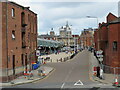
High Street, Hull
by Malc McDonald
geograph for square TA1028
The Lion and Key pub on High Street in Hull
|
|
Queen Street, Hull
by Malc McDonald
geograph for square TA1028
Queen Street in Hull. The street ends at the Humber Estuary.
|
|
Albert Dock, Hull
by Malc McDonald
geograph for square TA0927
Albert Dock in Hull.
|
|
Prince's Dock Street, Hull
by Malc McDonald
geograph for square TA0928
Prince's Dock Street in Hull.
|
|
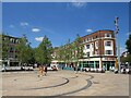
Queen Victoria Square, Hull
by Malc McDonald
geograph for square TA0928
Queen Victoria Square in the centre of Hull.
|
|
Hull Marina
by Lauren
geograph for square TA0928
Hull Marina opened in 1983 on the site of the former Railway Dock and Humber Dock
|
|
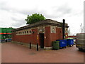
Public toilets, Hull docks
by Malc McDonald
geograph for square TA0928
A public toilet building in Hull's former docks.
|
|
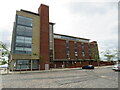
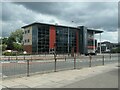
Office blocks at Humber Quays, Hull
by Malc McDonald
geograph for square TA0928
Modern office blocks at Humber Quays, in Hull's regenerated docklands.
|
|
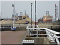
Lifting bridge, Railway Dock, Hull
by Malc McDonald
geograph for square TA0928
A lifting bridge across the mouth of Railway Dock in Hull.
|
|
Prospect Street, Hull
by Malc McDonald
geograph for square TA0929
Prospect Street in the centre of Hull, with the city's central library to the right.
|
|
Brook Street, Hull
by Malc McDonald
geograph for square TA0929
Brook Street in the centre of Hull. To the right of the street is the Debenhams... (more)
|
|
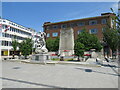
Statue and war memorial, Hull
by Malc McDonald
geograph for square TA0928
A statue and a war memorial in the centre of Hull.
|
|
The future of design and advanced manufacturing
by Christine Johnstone
geograph for square TA1029
Hull College announces its aspirations.
|
|
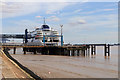
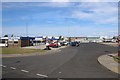
Ferry terminal number 1, Port of Hull
by Chris Allen
geograph for square TA1328
The P & O service from Hull to Totterdam departs from this river terminal at... (more)
|

|
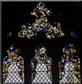
Gelder window, Holy Trinity church, Hull
by Julian P Guffogg
for square TA0928
Glass by Harry Stammers, 1952.
The window features King Edward I and the Abbot... (more)
|

|
Co-op Mosaic
by Lauren
for square TA0928
Commissioned in 1963 by the Hull and East Riding Co-operative Society for their... (more)
|
|
The Deep, Hull
by Jenny Hannan
geograph for square TA1028
By Terry Farrell and Partners, 2003.
|
|
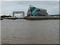
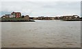
The confluence of the Rivers Hull and Humber
by Christine Johnstone
geograph for square TA1028
On a falling tide. The building is 'The Deep' - a large aquarium. The... (more)
|
|
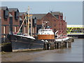
Arctic Corsair, River Hull
by Chris Allen
geograph for square TA1028
Hull's last surviving side trawler built in 1960 and now preserved as a... (more)
|

|
Carved pew end, Holy Trinity church, Hull
by Julian P Guffogg
for square TA0928
|
|
Stained glass window, Holy Trinity church, Hull
by Julian P Guffogg
for square TA0928
The original window was from 1871 by Gibbs, and was destroyed in a Zeppelin raid... (more)
|
|
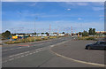
King George Dock, Hull
by Chris Allen
geograph for square TA1428
Operated by Associated British Ports and seen from a coach during a trip... (more)
|
|
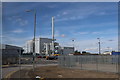
Biomass power station - Port of Hull
by Chris Allen
geograph for square TA1329
This is so new it has apparently not been commissioned (as of September 2019).... (more)
|
|
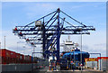
Hull Container Port
by Chris Allen
for square TA1428
This is a relatively new development in the Queen Elizabeth Dock. Seen from a... (more)
|
|
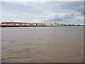
The Outer Basin of the former Victoria Dock, Hull
by Christine Johnstone
geograph for square TA1028
Now the centre of Victoria Dock Village. Seen from a boat on the River Humber.
|
|
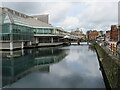
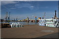
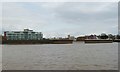
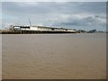
A boater's view of the Hull waterfront
by Christine Johnstone
for square TA0928
The Hull Quays, from the River Humber.
|
|
Pilot Boarding Station, Riverside Quay, Hull
by Christine Johnstone
geograph for square TA0927
At the eastern end of Albert Dock. Seen from a boat on the River Humber.
|
|
Quayside buildings at the west end of Albert Dock
by Christine Johnstone
geograph for square TA0827
A boater's view of Hull.
|
|
The Winding House, former Victoria Dock
by Chris Allen
geograph for square TA1028
This housed a steam engine for operating a Patent Slipway in the Victoria Dock.... (more)
|
|
Bulk handling conveyor - Port of Hull
by Chris Allen
geograph for square TA1528
Seen from a container storage area near the container port. The large conveyor... (more)
|
|
Hull Tidal Barrier
by Jenny Hannan
geograph for square TA1028
|
|
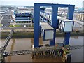
Ferry gantries at the Port of Hull
by Christine Johnstone
geograph for square TA1328
Seen from a departing Rotterdam ferry, which uses the berth on the Humber bank.
|
|
Albert Dock from the marina entrance, Hull
by Chris Allen
for square TA0927
|
|
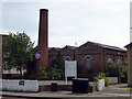
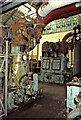
Power house, T J Smith and Nephew Ltd, Hull
by Chris Allen
for square TA0827
This firm of surgical dressing manufacturers had a pair of W H Allen inverted... (more)
|
|
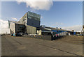
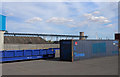
Port of Hull estate - level crossing
by Chris Allen
geograph for square TA1528
At the east end of the docks near the biomass storage facility. The coach... (more)
|
|
Port of Hull
by Chris Allen
geograph for square TA1328
On the left are the dock offices of Associated British Ports - Riverside House.... (more)
|