Public Tags
Other tags: Lanchester
car:Lanchester
Showing images tagged with place:Lanchester tag.
|
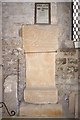
A Roman Altar (AD244) in Lanchester Church
by Stanley Howe for square NZ1647 One of a number of Roman Relicts found in Lanchester's Roman Fort at the... (more)
|
|
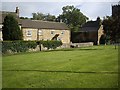
Lanchester Bowling Club
by Stanley Howe for square NZ1647 From path by A691 through Lanchester. College buildings in the background.
|
|
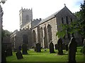
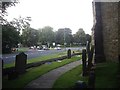
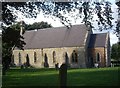
All Saints Church and Churchyard
by Stanley Howe geograph for square NZ1647 Lanchester.
|
|
Deneside, Lanchester
by Stanley Howe geograph for square NZ1647 Viewed across Peth Bank, from All Saints churchyard.
|
|
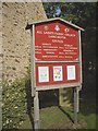
All Saints Parish Church notice board
by Stanley Howe for square NZ1647 In Lanchester churchyard.
|
|
Stone built houses on village green (east)
by Stanley Howe geograph for square NZ1647 Lanchester.
|
|
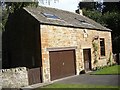
The Old Blacksmiths Shop, Lanchester
by Stanley Howe geograph for square NZ1647 By the A691. The stone plaque above the door reads:
BUILT
BY
SUBSCRIPTION
1819:
|
|
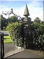
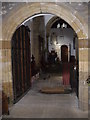
Exit gateway from All Saints churchyard, Lanchester
by Stanley Howe geograph for square NZ1647 With a metal cross and archway, and gatepost with spire, followed by a flight of... (more)
|
|
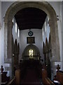
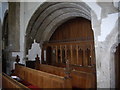
Chancel Arch and Nave, Lanchester Parish church
by Stanley Howe for square NZ1647 Looking west from the canon stalls in the chancel to an oak screen in the tower... (more)
Tags:
Chancel ArchX
ClockX
InteriorX
place:Lanchester
NaveX
Parish ChurchX
top:Religious SitesX
Royal ArmsX
Tower ArchX
|
|
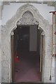
Vestry doorway, Lanchester All Saints
by Stanley Howe for square NZ1647 With cinquefoil arch; on the tympanum is a carving showing a seated figure, said... (more)
|
|
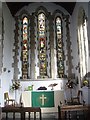
Altar and Chancel of Lanchester Parish Church
by Stanley Howe for square NZ1647 The three lancet windows behind the altar date from the early 13th century. The... (more)
Tags:
AltarX
Altar RailX
ChancelX
InteriorX
Lancet WindowsX
place:Lanchester
Parish ChurchX
top:Religious SitesX
|
|
'New' pews in Lanchester Parish chuerch
by Stanley Howe for square NZ1647 In 1939 when the last of the traditional 'family pew boxes' had been... (more)
|
|
Entrance to the nave of the Parish Church, Lanchester
by Stanley Howe for square NZ1647 From the South Porch; via a stout oak and iron-clad lockable door, with hood... (more)
Tags:
Church PorchX
Entrance DoorwayX
InteriorX
place:Lanchester
Parish ChurchX
top:Religious SitesX
|
|
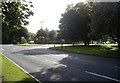
Village Green and road junction in Lanchester
by Stanley Howe geograph for square NZ1647 From the parish churchyard; SW corner of the church on the right.
|
|
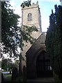
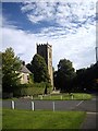
Lanchester Parish Church
by Stanley Howe geograph for square NZ1647 Approached from the south side. The tower dates from ca.1430, whilst the porch... (more)
|
|
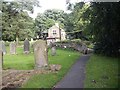
Public footpath across Peth Bank
by Stanley Howe geograph for square NZ1647 And entering All Saints churchyard, Lanchester.
|
|
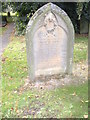
A Relieving Officer's grave in Lanchester
by Stanley Howe for square NZ1647 Redolent of the mid-C19 Poor Laws and Workhouses. See... (more)
|
|
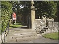
Access gate to All Saints, Lanchester
by Stanley Howe geograph for square NZ1647 Arched gateway, steps and stile.
|
|
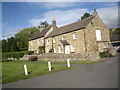
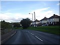
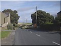
Housing on Peth Bank, Lanchester
by Stanley Howe geograph for square NZ1647 Viewed from the pathway through All Saints Parish Churchyard.
Tags:
top:Burial Ground, CrematoriumX
Churchyard PathX
HousingX
top:Housing, DwellingsX
place:Lanchester
Minor RoadX
|
|
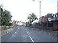
Old village houses in Lanchester
by Stanley Howe geograph for square NZ1647 By the A691, west of the Parish Church.
Tags:
A691X
top:Housing, DwellingsX
place:Lanchester
Old HousesX
Village GreenX
top:Village, Rural SettlementX
|
|
Old Manse and Parish Church, Lanchester
by Stanley Howe geograph for square NZ1647 At the north east corner of the village green, close to the A691.
|
|
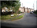
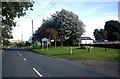
Road junction in Lanchester
by Stanley Howe geograph for square NZ1647 B6296 joining A691 at the village green.
|
|
The widened chancel of All Saints
by Stanley Howe for square NZ1647 To accommodate the canons' pews (1284AD), and now also the console for the... (more)
|
|
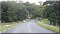
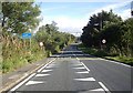
Bridge over River Deerness at Waterhouses
by Stanley Howe geograph for square NZ1740 Carrying Wolsingham Road.
Tags:
river:DeernessX
Esh WinningX
place:Lanchester
top:Rivers, Streams, DrainageX
top:Roads, Road TransportX
Stone Bridge Over RiverX
|
|
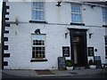
Black Horse Inn, Waterhouses
by Stanley Howe for square NZ1740 At the junction of Hamilton Row with Wolsingham Road
|
|
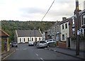
Russell Street, Waterhouses
by Stanley Howe geograph for square NZ1840 The former chapel at a bend in the road ahead is now a vehicle MOT centre.
Tags:
former:ChapelX
Esh WinningX
place:Lanchester
Minor RoadX
MOT GarageX
top:Village, Rural SettlementX
|
|
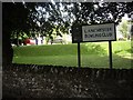
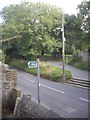
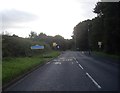
Village sign and speed limit, Waterhouses
by Stanley Howe geograph for square NZ1840 On the minor road from Esh Winning.
|
|
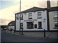
Stags Head Hotel, Esh Winning
by Stanley Howe geograph for square NZ1941 At the junction of Newhouse Road and Station View; a dogleg bend in the B6302.
Tags:
B6302X
top:Business, Retail, ServicesX
Dogleg Bend in RoadX
Esh WinningX
HotelX
place:Lanchester
|
|
Approach to junction of B6302 with Fairview in Newhouse
by Stanley Howe geograph for square NZ1842 The sign on the left is for the RC Queen of Martyrs church.
|
|
Willow Road, Newhouse
by Stanley Howe geograph for square NZ1842 B6302 entering Esh Winning.
|
|
Entering Esh Winning from the NW
by Stanley Howe geograph for square NZ1842 Via Newhouse Road (B6302).
|
|
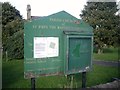
Notice board of the former Parish Church , Hamsteels
by Stanley Howe for square NZ1743 With notice of the church's deconsecration and sale, but with continuing... (more)
Tags:
top:Burial Ground, CrematoriumX
ChurchyardX
place:Lanchester
Minor RoadX
Notice BoardX
former:Parish ChurchX
|
|
Quebec hamlet
by Stanley Howe geograph for square NZ1743 On the minor road past the former church of Hamsteels.
|
|
Quarry House Farm, Wilk's Hill
by Stanley Howe geograph for square NZ1743 Looking downhill towards Front Street, Quebec (named for Wolfe's victory in... (more)
|
|
The former Parish Church of St John the Baptist, Hamsteels
by Stanley Howe geograph for square NZ1743 Sold off for use as a dwelling house by the Church Commissioners in early 2013.
|