Geograph - photograph every grid square
About tags on Geograph
Tags
Geographical Context
Subjects
Types
Other Prefixes
Public Tags
Related Tags
|
Coverage Map
Prefix:
place
Tag:
Llangernyw
Showing images tagged with
place:
Llangernyw
tag.
View all tagged images
-
In Browser
The Llangernyw Yew
by
Jeff Buck
geograph for square
SH8767
The Llangernyw Yew is believed to be aged between 4,000 years and 5,000 years... (
more
)
Tags:
Ancient Yew
X
Ancient Yew Tree
X
top:
Burial Ground, Crematorium
X
Churchyard
X
county:
Conwy
X
place:
Llangernyw
Llangernyw Yew
X
top:
Religious Sites
X
top:
Village, Rural Settlement
X
country:
Wales
X
top:
Wild Animals, Plants and Mushrooms
X
Yew
X
Yew Tree
X
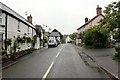
The A548 at Llangernyw
by
Jeff Buck
geograph for square
SH8767
The A548 as it heads south through Llangernyw.
Tags:
A Road (Classified A)
X
road:
A548
X
county:
Conwy
X
place:
Llangernyw
Road
X
top:
Roads, Road Transport
X
Village
X
top:
Village, Rural Settlement
X
country:
Wales
X
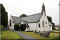
Saint Digain's Parish Church, Llangernyw
by
Jeff Buck
geograph for square
SH8767
Wikipedia
Link
Tags:
Church
X
Church (Church of Wales)
X
county:
Conwy
X
place:
Llangernyw
top:
Religious Sites
X
Saint Digain
X
top:
Village, Rural Settlement
X
country:
Wales
X
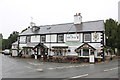
The Old Stag, Llangernyw
by
Jeff Buck
geograph for square
SH8767
The Old Stag was originally built as a farm in 1640, converted to a hotel in the... (
more
)
Tags:
17th Century Building
X
top:
Business, Retail, Services
X
county:
Conwy
X
Country Pub
X
place:
Llangernyw
Pub
X
top:
Village, Rural Settlement
X
country:
Wales
X
View more in the Image Search
or
in Browser
View images matching 'Llangernyw' anywhere
in
the tags
Don't click these:
PotMel 1
PotMel 2
☰
Home
View
Search
Marked Images
Maps
Browser
Explore
Showcase
New Images
Collections
Interact
Games
Discussions
Blog
Contributors
Submit
Statistics
Leaderboards
General
FAQ
Help Pages
Sitemap
Contact Us
Support Us
sponsored by
🔍
What to search:
Photos
Enter keywords or a location/postcode to search nearby images
Enter a Grid Reference
Placenames
Collections
Website Pages
Everything
Others:
Advanced Search
|
Image Browser
Or:
Coverage Map
|
Searchable Map
You are not logged in
login
|
register