Public Tags
Other tags: Lomond Hills
Showing images tagged with place:Lomond Hills tag.
|
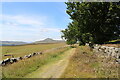
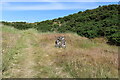
Path to limekiln
by Bill Kasman geograph for square NO2405 The path from Purin Hill car park proceeds towards the limekilns. The hill is... (more)
|
|
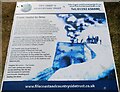
Information board at the limekiln
by Bill Kasman geograph for square NO2305 The hill is West Lomond (522m).
See limekiln article... (more)
Tags:
top:Derelict, DisusedX
type:GeographX
top:Historic Sites and ArtefactsX
disused:LimekilnX
place:Lomond Hills
Lomond Hills Regional ParkX
top:PathsX
|
|
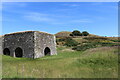
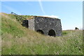
The limekiln
by Bill Kasman geograph for square NO2305 The hill is East Lomond (448m).
See limekiln article... (more)
Tags:
top:Derelict, DisusedX
type:GeographX
top:Historic Sites and ArtefactsX
disused:LimekilnX
place:Lomond Hills
Lomond Hills Regional ParkX
top:PathsX
|
|
The limekiln
by Bill Kasman geograph for square NO2305 The hill is West Lomond (522m). Part of the pond is visible.
See limekiln... (more)
Tags:
type:GeographX
top:Historic Sites and ArtefactsX
disused:LimekilnX
place:Lomond Hills
Lomond Hills Regional ParkX
top:PathsX
|
|
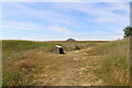
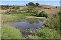
Pond at the limekiln
by Bill Kasman geograph for square NO2305 One of the information boards gives details of local wildlife (allegedly) found... (more)
Tags:
top:Derelict, DisusedX
type:GeographX
top:Historic Sites and ArtefactsX
top:Lakes, Wetland, BogX
disused:LimekilnX
place:Lomond Hills
Lomond Hills Regional ParkX
top:PathsX
|
|
The limekiln
by Bill Kasman geograph for square NO2305 From the path from Purin Hill car park the limekiln comes into view.
See... (more)
Tags:
top:Derelict, DisusedX
type:GeographX
top:Historic Sites and ArtefactsX
disused:LimekilnX
place:Lomond Hills
Lomond Hills Regional ParkX
top:PathsX
|
|
Path to limekiln
by Bill Kasman geograph for square NO2405 The path from Purin Hill car park proceeds towards the limekiln. The trees ahead... (more)
|
|
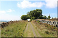
Path to the limekiln
by Bill Kasman geograph for square NO2505 The path to the old limekiln starts from the car park at Purin Hill.
See... (more)
Tags:
top:Derelict, DisusedX
type:GeographX
top:Historic Sites and ArtefactsX
disused:LimekilnX
place:Lomond Hills
Lomond Hills Regional ParkX
top:PathsX
|
|
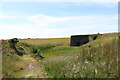
The limekiln
by Bill Kasman geograph for square NO2305 One of the information boards. The rubble plinth for all of the boards at the... (more)
Tags:
top:Derelict, DisusedX
type:GeographX
top:Historic Sites and ArtefactsX
disused:LimekilnX
place:Lomond Hills
Lomond Hills Regional ParkX
top:PathsX
|
|
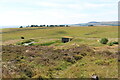
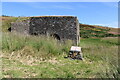
The limekiln
by Bill Kasman geograph for square NO2305 This fence is intended to block access to the top of the limekiln although... (more)
Tags:
top:Derelict, DisusedX
type:GeographX
top:Historic Sites and ArtefactsX
disused:LimekilnX
place:Lomond Hills
Lomond Hills Regional ParkX
top:PathsX
|
|
The limekiln
by Bill Kasman geograph for square NO2305 See limekiln article Link
Tags:
top:Derelict, DisusedX
type:GeographX
top:Historic Sites and ArtefactsX
disused:LimekilnX
place:Lomond Hills
Lomond Hills Regional ParkX
top:PathsX
|
|
The limekiln
by Bill Kasman geograph for square NO2305 With one of the information boards.
See limekiln article... (more)
Tags:
top:Derelict, DisusedX
type:GeographX
top:Historic Sites and ArtefactsX
disused:LimekilnX
place:Lomond Hills
Lomond Hills Regional ParkX
top:PathsX
|
|
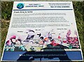
Information board at the limekiln
by Bill Kasman for square NO2305 This is one of several information boards around the limekiln, These boards have... (more)
Tags:
type:Close LookX
top:Derelict, DisusedX
top:Historic Sites and ArtefactsX
disused:LimekilnX
place:Lomond Hills
Lomond Hills Regional ParkX
top:PathsX
|
|
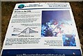
Information board at the limekiln
by Bill Kasman for square NO2305 This is one of several information boards around the limekiln, These boards have... (more)
Tags:
type:Close LookX
top:Derelict, DisusedX
top:Historic Sites and ArtefactsX
disused:LimekilnX
place:Lomond Hills
Lomond Hills Regional ParkX
top:PathsX
|
|
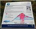
Information board at the limekiln
by Bill Kasman for square NO2305 This is one of several information boards around the limekiln, These boards have... (more)
Tags:
type:Close LookX
top:Derelict, DisusedX
top:Historic Sites and ArtefactsX
disused:LimekilnX
place:Lomond Hills
Lomond Hills Regional ParkX
top:PathsX
|
|
The limekiln
by Bill Kasman geograph for square NO2305 These duckboards, as well as several sections of wooden steps over boggy areas,... (more)
Tags:
top:Derelict, DisusedX
type:GeographX
top:Historic Sites and ArtefactsX
disused:LimekilnX
place:Lomond Hills
Lomond Hills Regional ParkX
top:PathsX
|
|
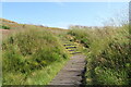
The limekiln
by Bill Kasman geograph for square NO2305 These wooden steps, as well as several sections of duckboards over boggy areas,... (more)
Tags:
top:Derelict, DisusedX
type:GeographX
top:Historic Sites and ArtefactsX
disused:LimekilnX
place:Lomond Hills
Lomond Hills Regional ParkX
top:PathsX
|
|
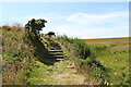
The limekiln
by Bill Kasman geograph for square NO2305 The path guides visitors around the limekiln. The steps are handy!
See limekiln... (more)
Tags:
top:Derelict, DisusedX
type:GeographX
top:Historic Sites and ArtefactsX
disused:LimekilnX
place:Lomond Hills
Lomond Hills Regional ParkX
top:PathsX
|
|
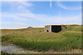
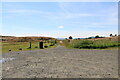
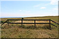
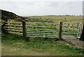
Gate to limekiln
by Bill Kasman geograph for square NO2306 The area of the limekiln is fenced-off to keep out curious sheep and cattle.... (more)
Tags:
top:Derelict, DisusedX
type:GeographX
top:Historic Sites and ArtefactsX
former:LimekilnX
place:Lomond Hills
Lomond Hills Regional ParkX
top:PathsX
|
|
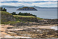
Quarrel Sand
by Ian Capper geograph for square NT5885 Looking along Quarrel Sand towards Horseshoe Point. Beyond is the island of... (more)
Tags:
top:CoastalX
place:CraigleithX
type:GeographX
place:Lomond Hills
near:North BerwickX
place:Quarrel SandX
|