Public Tags
Prefix:
place
Tag:
Lower·Dinchope
Showing images tagged with place:Lower Dinchope tag.
|
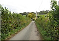
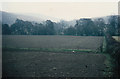
By Ireland to the Monument - Lower Dinchope, Shropshire
by Martin Richard Phelan
geograph for square SO4483
An October morning in the lane from the B4368 east of Craven Arms to the hamlet... (more)
|
|
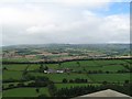
Flounders Folly view south - Lower Dinchope, Shropshire
by Martin Richard Phelan
for square SO4584
Another view from the tower, this time overlooking the path alongside Callowhill... (more)
|
|
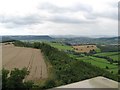
Flounders Folly Shropshire patchwork - Lower Dinchope, Shropshire
by Martin Richard Phelan
for square SO4585
Another view from the Folly, looking in a similar direction, north-west towards... (more)
|
|
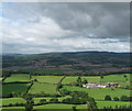
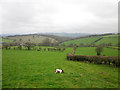
Flounders Folly to Moorwood - Lower Dinchope, Shropshire
by Martin Richard Phelan
for square SO4585
A view from the tower, looking north-west towards Wenlock Edge and beyond it the... (more)
|
|
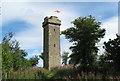
Flounders Folly south face - Lower Dinchope, Shropshire
by Martin Richard Phelan
geograph for square SO4685
Flounders Folly, also known locally as the Monument, stands on Callow Hill to... (more)
|
|
At rest at Dinchope - Lower Dinchope, Shropshire
by Martin Richard Phelan
for square SO4584
The grave at Lower Dinchope of champion racehorse Grove Sprightly. The... (more)
|
|
Footpath to Lower Dinchope
by Jeff Buck
geograph for square SO4584
Public footpath heading away from Hanging Wood towards Lower Dinchope.
|
|
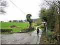
Approaching Lower Dinchope
by Jeff Buck
geograph for square SO4484
Approaching Lower Dinchope along the Shropshire Way.
|
|
To the Quinny and beyond - Wistanstow, Shropshire
by Martin Richard Phelan
geograph for square SO4385
To the south-east of Wistanstow this footpath leads from the A49 at Grove Bank... (more)
|
|
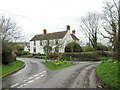
Lower Dinchope, Shropshire
by Jeff Buck
geograph for square SO4584
The Shropshire Way LDP continues to the right of the junction.
|
|
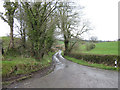
Lane to Strefford
by Jeff Buck
geograph for square SO4484
Lane heading north towards Strefford from the Shropshire Way near Lower Dinchope.
|