Public Tags
Showing images tagged with place:Meols tag.
|
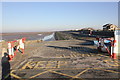
The Slipway at Meols
by Jeff Buck geograph for square SJ2390 The slipway at Meols on the Wirral with the Wallasey Embankment in the distance.... (more)
|
|
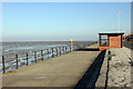
The Promenade at Meols
by Jeff Buck geograph for square SJ2290 Looking north east along the promenade next to Meols Parade.
Wikipedia... (more)
|
|
North Wirral Coastal Park (Meols Dunes)
by Jeff Buck geograph for square SJ2390 The North Wirral Coastal Park follows the route of the coastline between Dove... (more)
|

|
View from Dove Point
by Jeff Buck geograph for square SJ2390 The view north north-east across the Irish Sea from Dove Point at Meols on the... (more)
|
|
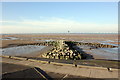
Breakwater on the Wallasey Embankment
by Jeff Buck geograph for square SJ2491 An anchor-shaped breakwater on the Wallasey Embankment between Meols and Leasowe... (more)
Tags:
BreakwaterX
top:CoastalX
Coastal DefenceX
Coastal ParkX
country:EnglandX
type:GeographX
Irish SeaX
place:Meols
county:MerseysideX
Mud FlatsX
SeafrontX
place:WirralX
Wirral PeninsulaX
|
|
Breakwater on the Wallasey Embankment
by Jeff Buck geograph for square SJ2491 An anchor-shaped breakwater on the Wallasey Embankment between Meols and Leasowe... (more)
|
|
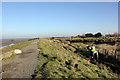
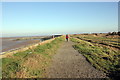
Path through the Wirral Coastal Park
by Jeff Buck geograph for square SJ2490 The North Wirral Coastal Park follows the route of the coastline between Dove... (more)
|
|
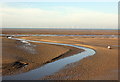
Mudflats at Parkfields
by Jeff Buck geograph for square SJ2390 Looking across the mudflats from the Wallasey Embankment at Parkfields near... (more)
|

|
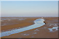
Mudflats at Mockbeggar Wharf
by Jeff Buck geograph for square SJ2390 Looking north west across the mudflats at Dove Point, Meols.
|
|
East Hoyle Bank
by Jeff Buck geograph for square SJ2290 The view north across East Hoyle Bank from the promenade at Meols.
|
|
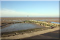
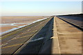
The Wallasey Embankment at Meols
by Jeff Buck geograph for square SJ2390 The Wallasey Embankment was built to protect part of the low-lying north coast... (more)
|