Public Tags
Showing images tagged with place:North Stoke tag.
|
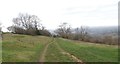
A new route for the Cotswold Way
by HelenK geograph for square ST7069 On my OS Explorer map from the 1990s, this stretch of the Cotswold Way runs on a... (more)
Tags:
place:BathX
BywayX
long distance path:Cotswold WayX
type:GeographX
place:North Stoke
top:PathsX
top:Village, Rural SettlementX
|
|
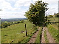
Bridleway leading towards North Stoke
by HelenK geograph for square ST7068 The wooden structure which has fallen over on the left may once have been a sign... (more)
Tags:
BridlewayX
top:Farm, Fishery, Market GardeningX
type:GeographX
place:KelstonX
place:North Stoke
top:PathsX
Sheep FarmingX
top:Village, Rural SettlementX
|
|
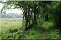
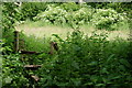
Footpath Near North Stoke
by Peter Trimming geograph for square TQ0310 One of the better stretches, with evidence of some tree thinning to the east of... (more)
|
|
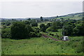
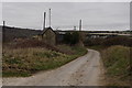
North Stoke
by Peter Trimming geograph for square TQ0210 The view south, from just off the road.
|
|
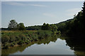
River Arun
by Peter Trimming geograph for square TQ0110 Looking south, from west of North Stoke. The wooded area is in Arundel Park.
Tags:
type:GeographX
place:North Stoke
River ArunX
top:Rivers, Streams, DrainageX
county:SussexX
top:Woodland, ForestX
|
|
North Stoke
by Peter Trimming geograph for square TQ0210 The hamlet lies immediately south of Amberley.
|
|
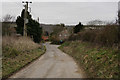
Towards North Stoke
by Peter Trimming geograph for square TQ0210 The hamlet lies immediately south of Amberley.
Tags:
top:LowlandsX
place:North Stoke
top:Roads, Road TransportX
county:SussexX
top:Village, Rural SettlementX
|
|
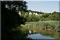
River Arun
by Peter Trimming geograph for square TQ0110 Looking north. On the chalk cliffs, just beyond the lone tree, runs the B2139; a... (more)
Tags:
type:GeographX
place:North Stoke
River ArunX
top:Rivers, Streams, DrainageX
top:Rocks, Scree, CliffsX
county:SussexX
|
|
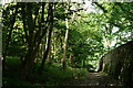
The Well-worn Path
by Peter Trimming geograph for square TQ0310 I don't remember it being much better on my previous visit in 2009.
|
|
Arundel Park
by Peter Trimming geograph for square TQ0110 View towards the exit to the path adjoining the River Arun.
Tags:
Arundel ParkX
top:Country EstatesX
type:GeographX
place:North Stoke
top:PathsX
county:SussexX
top:Woodland, ForestX
|
|
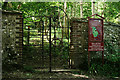
Entrance to Arundel Park
by Peter Trimming geograph for square TQ0110 Seen from the bridleway which runs close to the River Arun. When inside the... (more)
Tags:
Arundel ParkX
top:Country EstatesX
type:GeographX
place:North Stoke
top:PathsX
county:SussexX
top:Woodland, ForestX
|