Public Tags
Showing latest 50 of 70 images tagged with place:Ranmore Common tag.
|
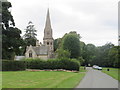
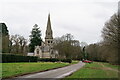
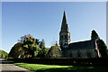
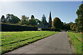
Ranmore Common Road, near Dorking
by Malc McDonald geograph for square TQ1450 A view of Ranmore Common Road and St. Barnabas Church, at Ranmore Common in... (more)
Tags:
subject:ChurchX
Church with SpireX
near:DorkingX
type:GeographX
Minor Rural RoadX
place:North DownsX
place:RanmoreX
place:Ranmore Common
top:Religious SitesX
Rural RoadX
county:SurreyX
|
|
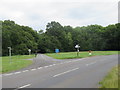
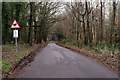
Ranmore Common Road, near Dorking
by Malc McDonald geograph for square TQ1450 Ranmore Common Road at Ranmore Common, near Dorking.
Tags:
near:DorkingX
type:GeographX
Minor Rural RoadX
place:North DownsX
place:RanmoreX
place:Ranmore Common
subject:Road JunctionX
Road JunctionX
top:Roads, Road TransportX
Rural RoadX
Rural Road JunctionX
county:SurreyX
|
|
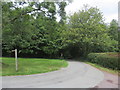
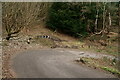
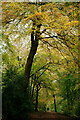
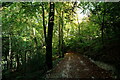
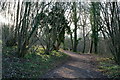
Ranmore Common Road, near Dorking
by Malc McDonald geograph for square TQ1550 Ranmore Common Road heading into woodland on the North Downs.
Tags:
near:DorkingX
type:GeographX
Minor Rural RoadX
place:North DownsX
place:RanmoreX
place:Ranmore Common
subject:RoadX
top:Roads, Road TransportX
Rural RoadX
county:SurreyX
|
|
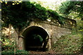
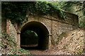
Ranmore Common
by Peter Trimming geograph for square TQ1450 Bridge carrying the road from Dorking up to Ranmore Common, at the point where... (more)
|
|
Ranmore Common
by Peter Trimming geograph for square TQ1551 On the lower slope, which runs down to Ranmore Common Road.
Tags:
top:Farm, Fishery, Market GardeningX
type:GeographX
top:GrasslandX
place:Ranmore Common
county:SurreyX
near:WesthumbleX
top:Woodland, ForestX
|
|
Ranmore Common
by Peter Trimming for square TQ1450 Bridge carrying the road from Dorking up to Ranmore Common, at the point where... (more)
Tags:
subject:BridgeX
Carriage DriveX
type:Close LookX
near:DorkingX
top:PathsX
place:Ranmore Common
county:SurreyX
|
|
Ranmore Common
by Peter Trimming for square TQ1450 Bridge carrying the road from Dorking up to Ranmore Common, at the point where... (more)
Tags:
subject:BridgeX
Carriage DriveX
type:Close LookX
near:DorkingX
top:PathsX
place:Ranmore Common
county:SurreyX
|
|
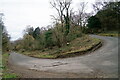
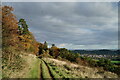
Ranmore Common
by Peter Trimming geograph for square TQ1450 The hairpin bend, near the top of Ranmore Common Road.
I have mixed memories... (more)
Tags:
type:GeographX
place:Ranmore Common
top:Roads, Road TransportX
top:Sport, LeisureX
county:SurreyX
top:Woodland, ForestX
|
|
Ranmore Common
by Peter Trimming geograph for square TQ1450 The hairpin bend, near the top of Ranmore Common Road.
I have mixed memories... (more)
Tags:
type:GeographX
place:Ranmore Common
top:Roads, Road TransportX
top:Sport, LeisureX
county:SurreyX
top:Woodland, ForestX
|
|
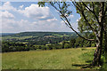
Across to Westhumble
by Ian Capper geograph for square TQ1752 Looking from the slopes of Lodge Hill across the Mole Gap to the village of... (more)
Tags:
place:Box HillX
place:Denbies VineyardX
near:DorkingX
top:Farm, Fishery, Market GardeningX
top:GrasslandX
place:Lodge HIllX
place:Ranmore Common
place:WesthumbleX
top:Woodland, ForestX
|
|
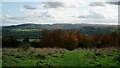
Ranmore Common
by Peter Trimming geograph for square TQ1450 The view south, towards Leith Hill. The tower, on the summit of Leith Hill, is... (more)
Tags:
type:GeographX
top:Heath, ScrubX
place:Leith HillX
place:Ranmore Common
county:SurreyX
subject:ViewX
top:Woodland, ForestX
|
|
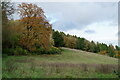
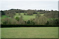
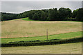
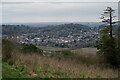
View From Polesden Lacey
by Peter Trimming geograph for square TQ1352 Looking towards Ranmore Common, with Yewtree Farm just visible to the right of picture.
Tags:
top:Country EstatesX
near:EffinghamX
type:GeographX
National Trust PropertyX
place:Polesden LaceyX
place:Ranmore Common
county:SurreyX
top:Village, Rural SettlementX
top:Woodland, ForestX
|
|
View Towards Chapel Lane
by Peter Trimming geograph for square TQ1552 This location lies to the west of Westhumble. The distant woods lie on the... (more)
Tags:
top:Farm, Fishery, Market GardeningX
type:GeographX
top:GrasslandX
top:LowlandsX
place:Ranmore Common
county:SurreyX
place:WesthumbleX
top:Woodland, ForestX
|
|
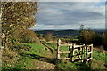
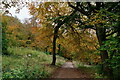
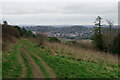
Ranmore Common
by Peter Trimming geograph for square TQ1450 Along the path, a walker stops to admire the view towards Dorking.
Tags:
type:GeographX
top:Heath, ScrubX
top:PathsX
place:Ranmore Common
county:SurreyX
subject:ViewX
top:Woodland, ForestX
|
|
Ranmore Common
by Peter Trimming geograph for square TQ1450 View in the direction of Dorking.
Tags:
type:GeographX
top:Heath, ScrubX
top:PathsX
place:Ranmore Common
county:SurreyX
subject:ViewX
top:Woodland, ForestX
|
|
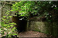
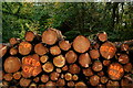
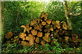
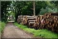
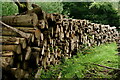
Ranmore Common
by Peter Trimming for square TQ1350 Stacked timber, awaiting removal.
Tags:
type:Close LookX
National Trust LandX
place:Ranmore Common
county:SurreyX
Timber StackX
top:Woodland, ForestX
|
|
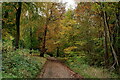
Ranmore Common
by Peter Trimming geograph for square TQ1351 The track leading away from Tanner's Hatch.
Tags:
type:GeographX
National Trust LandX
place:Ranmore Common
top:Roads, Road TransportX
county:SurreyX
top:Woodland, ForestX
|
|
Ranmore Common
by Peter Trimming geograph for square TQ1351 The track leading away from Tanner's Hatch.
Tags:
type:GeographX
National Trust LandX
place:Ranmore Common
top:Roads, Road TransportX
county:SurreyX
top:Woodland, ForestX
|
|
Ranmore Common
by Peter Trimming geograph for square TQ1351 The track leading away from Tanner's Hatch.
Tags:
type:GeographX
National Trust LandX
place:Ranmore Common
top:Roads, Road TransportX
county:SurreyX
top:Woodland, ForestX
|
|
Ranmore Common
by Peter Trimming geograph for square TQ1351 The track leading away from Tanner's Hatch.
Tags:
type:GeographX
National Trust LandX
place:Ranmore Common
top:Roads, Road TransportX
county:SurreyX
top:Woodland, ForestX
|
|
Ranmore Common
by Peter Trimming geograph for square TQ1351 The track leading away from Tanner's Hatch.
Tags:
type:GeographX
National Trust LandX
place:Ranmore Common
top:Roads, Road TransportX
county:SurreyX
top:Woodland, ForestX
|
|
Ranmore Common
by Peter Trimming geograph for square TQ1450 Part of the Denbies Hillside walk, with Dorking in the distance.
|
|
Ranmore Common
by Peter Trimming geograph for square TQ1450 Part of the Denbies Hillside walk, with Dorking in the distance.
|
|
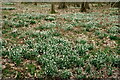
Ranmore Common
by Peter Trimming for square TQ1450 Snowdrops in full bloom.
|
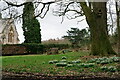
|
Ranmore Common
by Peter Trimming geograph for square TQ1450 Snowdrops in full bloom.
Tags:
type:GeographX
place:Ranmore Common
top:Religious SitesX
plant:SnowdropX
county:SurreyX
top:Village, Rural SettlementX
top:Woodland, ForestX
|
|
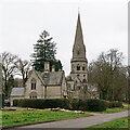
Saint Barnabas Church
by Peter Trimming geograph for square TQ1450 A large church on the top of Ranmore Common.
Tags:
type:GeographX
place:Ranmore Common
top:Religious SitesX
top:Roads, Road TransportX
county:SurreyX
top:Village, Rural SettlementX
|
|
Saint Barnabas Church
by Peter Trimming geograph for square TQ1450 A large church on the top of Ranmore Common.
Tags:
type:GeographX
place:Ranmore Common
top:Religious SitesX
top:Roads, Road TransportX
county:SurreyX
top:Village, Rural SettlementX
top:Woodland, ForestX
|
|
Polesden Lacey Estate
by Peter Trimming geograph for square TQ1450 Path leading from Ranmore Common Road towards Denbies Vineyard.
Tags:
type:GeographX
National Trust LandX
top:PathsX
place:Ranmore Common
county:SurreyX
top:Woodland, ForestX
|
|
Ranmore Common
by Peter Trimming geograph for square TQ1451 A forestry track, leading away from Tanner's Hatch.
Tags:
type:GeographX
place:Ranmore Common
top:Roads, Road TransportX
county:SurreyX
top:Woodland, ForestX
|
|
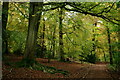
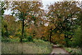
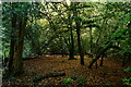
Ranmore Common
by Peter Trimming geograph for square TQ1350 Mixed woodland, seen from one of the main tracks. Further along this track, and... (more)
|
|
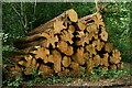
Ranmore Common
by Peter Trimming for square TQ1350 Felled timber, due to selective thinning on the National Trust estate. Virtually... (more)
|
|
St. Barnabas Church
by Peter Trimming geograph for square TQ1450 Situated on the top of Ranmore Common.
Tags:
type:GeographX
place:Ranmore Common
top:Religious SitesX
top:Roads, Road TransportX
county:SurreyX
top:Village, Rural SettlementX
|
|
St. Barnabas Church
by Peter Trimming geograph for square TQ1450 Situated on the top of Ranmore Common.
Tags:
type:GeographX
place:Ranmore Common
top:Religious SitesX
top:Roads, Road TransportX
county:SurreyX
top:Village, Rural SettlementX
|
|
Ranmore Common
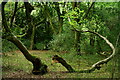
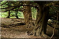
by Peter Trimming geograph for square TQ1450 Two separate parts of a still-living tree.
|
|
Ranmore Common
by Peter Trimming geograph for square TQ1450 Several veteran yew trees line the route of what appears to be a mountain bike trail.
|
|
Ranmore Common
by Peter Trimming geograph for square TQ1350 Looking towards Rose Tree Cottage.
Tags:
near:DorkingX
type:GeographX
National Trust LandX
place:Ranmore Common
county:SurreyX
Timber StackX
top:Village, Rural SettlementX
top:Woodland, ForestX
|
|
Ranmore Common
by Peter Trimming for square TQ1350 Felled timber, due to selective thinning on the National Trust estate.
Tags:
type:Close LookX
near:DorkingX
National Trust LandX
place:Ranmore Common
county:SurreyX
Timber StackX
top:Woodland, ForestX
|
|
Ranmore Common
by Peter Trimming for square TQ1350 Felled timber, due to selective thinning on the National Trust estate.
Tags:
type:Close LookX
near:DorkingX
National Trust LandX
place:Ranmore Common
county:SurreyX
Timber StackX
top:Woodland, ForestX
|
|
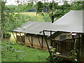
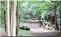
Tanner's Hatch - Glampsite
by Colin Smith geograph for square TQ1451 "Glamour Camping" at the Youth Hostel in Bagden Wood, Ranmore Common.
|
|
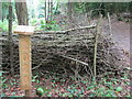
Ranmore Common - 2020
by Colin Smith for square TQ1451 A newly laid hedge, with date post, by Tanner's Hatch.
|
|
Ranmore Common
by Colin Smith for square TQ1450 Mixed woodland with a dense network of paths on the dip slope of the North Downs.
Tags:
type:Cross GridX
subject:PathX
top:PathsX
place:Ranmore Common
top:UplandsX
top:Woodland, ForestX
|
|
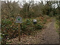
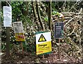
Ranmore Common - Forestry Work
by Colin Smith for square TQ1350 A map, notices and signs advising visitors that work is in progress to combat... (more)
Tags:
Ash Dieback DiseaseX
type:Close LookX
subject:ForestryX
place:Ranmore Common
SignsX
Warning NoticesX
top:Woodland, ForestX
|
|
Ranmore Common
by Colin Smith geograph for square TQ1350 Start of the track leading from the ridgetop road to secluded Tanner's... (more)
|
|
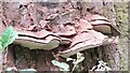
Ranmore Common - Bracket Fungi
by Colin Smith for square TQ1350 Fungal growth on a tree trunk.
Tags:
Bracket FungiX
type:Close LookX
subject:FungiX
place:Ranmore Common
top:Wild Animals, Plants and MushroomsX
|
|
Ranmore Common
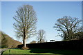
by Peter Trimming geograph for square TQ1450 Roadside above the Denbies Estate.
|
|
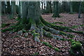
Beech Roots
by Peter Trimming geograph for square TQ1351 A stand of beech trees, adjacent to an area of Ranmore Common which has recently... (more)
|
|
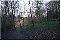
Ranmore Common
by Peter Trimming geograph for square TQ1351 The path towards Tanner's Hatch youth hostel. To the right of the path, the... (more)
|
|
Ranmore Common
by Peter Trimming geograph for square TQ1351 The path towards Tanner's Hatch youth hostel. To the right of the path, the... (more)
|
|
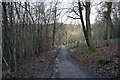
Ranmore Common
by Peter Trimming geograph for square TQ1351 The path away from Tanner's Hatch youth hostel.
|
|
Ranmore Common Road
by Peter Trimming geograph for square TQ1550 The top of the climb where, in October 2000, I won £20 as the fastest veteran in... (more)
Tags:
near:DorkingX
type:GeographX
place:Ranmore Common
top:Roads, Road TransportX
county:SurreyX
top:Woodland, ForestX
|