Public Tags
Other tags: River Otter
Showing images tagged with place:River Otter tag.

|
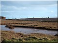
Nets in the flooded River Otter
by David Smith geograph for square SY0782 These are the cricket nets for Budleigh Salterton cricket club; the field floods... (more)
Tags:
place:Budleigh SaltertonX
Cricket NetsX
Flooded FieldX
top:Lakes, Wetland, BogX
place:River Otter
top:Rivers, Streams, DrainageX
top:Sport, LeisureX
|
|
Wetlands and walkers at the mouth of the River Otter
by David Smith for square SY0781 After a few days of wet weather, Sunday 16th February 2014 was dry and sunny, so... (more)
Tags:
top:CoastalX
top:Lakes, Wetland, BogX
place:River Otter
top:Rivers, Streams, DrainageX
WalkersX
|
|
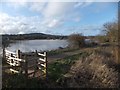
Floods beside the River Otter at White Bridge
by David Smith geograph for square SY0783 The path runs beside the river. The fields beyond had been flooded for some time.
Tags:
Flooded FieldsX
top:Lakes, Wetland, BogX
top:PathsX
place:River Otter
top:Rivers, Streams, DrainageX
|
|
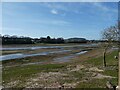
Formation of tidal marshland, Lower Otter Restoration Project
by David Smith geograph for square SY0782 |
|
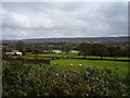
The River Otter in flood
by Anthony Vosper for square SY0992 Viewed from a trackway on North Hill.
Flooding is a common event during the... (more)
Tags:
top:Farm, Fishery, Market GardeningX
Flood WaterX
place:River Otter
top:Rivers, Streams, DrainageX
|
|
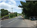
Bridge in Alfington
by David Smith geograph for square SY1197 The B3177 crosses a stream which flows into the River Otter to the west of the village.
Tags:
BridgeX
place:River Otter
top:Rivers, Streams, DrainageX
top:Roads, Road TransportX
top:Village, Rural SettlementX
|
|
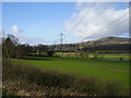
Pylons and pastures
by Anthony Vosper geograph for square ST1601 A view across the otter valley outside Honiton.
|
|
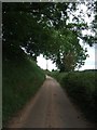
Country road just south of Ashtree Farm
by David Smith geograph for square SY0988 The road links isolated farms on the east side of the River Otter
|
|
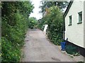
Mill Lane leading to Fenny Bridge
by David Smith geograph for square SY1197 The road becomes a footpath beside the River Otter
|