Public Tags
Other tags: Sirhowy Valley
Showing images tagged with place:Sirhowy Valley tag.
|
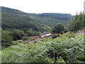
Houses in the Sirhowy Valley, Hollybush
by Jaggery geograph for square SO1603 Railway Terrace houses, on the west bank of the River Sirhowy, viewed from the A4048.
|
|
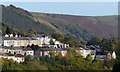
Hillside houses, Georgetown
by Robin Drayton for square SO1408 A view from the centre of Tredegar across the Sirhowy Valley.
This is the view... (more)
Tags:
place:Georgetown (Tredegar)X
top:Housing, DwellingsX
place:Sirhowy Valley
top:Suburb, Urban FringeX
Terraced HousesX
View Across ValleyX
|
|
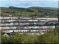
Terraced housing, Georgetown
by Robin Drayton for square SO1408 A view from the centre of Tredegar across the Sirhowy Valley.
Tags:
place:Georgetown (Tredegar)X
top:Housing, DwellingsX
place:Sirhowy Valley
top:Suburb, Urban FringeX
Terraced HousesX
View Across ValleyX
|
|
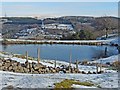
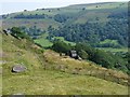
Pond near Cefn Golau Cemetery
by Robin Drayton geograph for square SO1407 View across the Sirhowy Valley towards Peacehaven with a radio mast on the... (more)
|
|
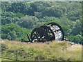
Winding wheel above Bedwellty Pits, Sirhowy Valley
by Robin Drayton geograph for square SO1505 This was associated with the nearby quarry... (more)
Tags:
place:Bedwellty PitsX
former:QuarryX
top:Quarrying, MiningX
place:Sirhowy Valley
Winding WheelX
|
|
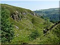
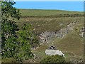
Former quarry above Bedwellty Pits
by Robin Drayton geograph for square SO1505 On the western side of the Sirhowy Valley.
|
|
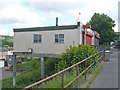
Colin's Fish Bar, Pontllanfraith
by Robin Drayton geograph for square ST1795 Situated in Commercial Street.
Built on a hillside overlooking the Sirhowy Valley.
Tags:
top:Business, Retail, ServicesX
Fish and Chip ShopX
place:PontllanfraithX
place:Sirhowy Valley
|
|
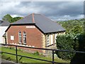
Pontllanfraith Methodist Church
by Robin Drayton geograph for square ST1795 Built on a hillside overlooking the Sirhowy Valley.
|
|
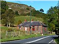
Former school, Bedwellty Pits
by Robin Drayton geograph for square SO1505 On the A4048 near to Lower Farm.
This small school, opened in 1879, housed... (more)
Tags:
road:A4048X
place:Bedwellty PitsX
top:Educational SitesX
former:SchoolX
place:Sirhowy Valley
top:Village, Rural SettlementX
|
|
Winding wheel, Bedwellty Pits
by Robin Drayton geograph for square SO1505 Viewed from the A4048.
For a view of the wheel from above and more details see... (more)
Tags:
place:Bedwellty PitsX
top:Historic Sites and ArtefactsX
top:Quarrying, MiningX
place:Sirhowy Valley
Winding WheelX
|
|
Winding wheel, Bedwellty Pits
by Robin Drayton geograph for square SO1505 For as view of this wheel and its surroundings, see... (more)
Tags:
place:Bedwellty PitsX
top:Historic Sites and ArtefactsX
former:QuarryX
top:Quarrying, MiningX
place:Sirhowy Valley
Winding WheelX
|