Geograph - photograph every grid square
About tags on Geograph
Tags
Geographical Context
Subjects
Types
Other Prefixes
Public Tags
Related Tags
|
Coverage Map
Prefix:
place
Tag:
Rushall
Other tags:
Rushall
at:
Rushall
Showing images tagged with
place:
Rushall
tag.
View all tagged images
-
In Browser
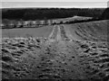
Path leading to Rushall Drove
by
Gillie Rhodes
geograph for square
SU1155
This is a permissive path through a cultivated field leading from Charlton Drove... (
more
)
Tags:
Cleeve Hill
X
top:
Farm, Fishery, Market Gardening
X
Field Path
X
top:
Grassland
X
top:
Lowlands
X
top:
Paths
X
place:
Rushall
Rushall Hill
X
place:
Wiltshire
X
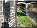
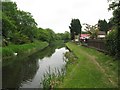
Where past meets present - Yew Tree, West Midlands
by
Martin Richard Phelan
geograph for square
SP0394
The Rushall Canal was constructed in 1847 to provide a link between the Daw End... (
more
)
Tags:
top:
Canals
X
top:
Lowlands
X
M6 Corridor
X
top:
Rivers, Streams, Drainage
X
top:
Roads, Road Transport
X
place:
Rushall
Rushall Canal
X
top:
Suburb, Urban Fringe
X
place:
Walsall
X
West Midlands
X
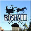
Rushall village sign
by
Adrian S Pye
for square
TM1982
The sign depicts a horse-drawn binder symbolizing the agricultural nature of the village.
Tags:
type:
Close Look
X
county:
Norfolk
X
Norfolk Village Signs
X
place:
Rushall
Rushall - Norfolk
X
Straw Binder
X
subject:
Village Sign
X
Village Sign
X
Village Sign Detail
X
Village Sign Norfolk
X
top:
Village, Rural Settlement
X
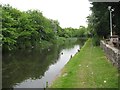
Ducks at Daw End - Walsall, West Midlands
by
Martin Richard Phelan
geograph for square
SK0300
A view, with mallards, of the Daw End Branch Canal, taken beside the Boathouse... (
more
)
Tags:
area:
Black Country
X
subject:
Canal
X
top:
Canals
X
place:
Catshill Junction
X
Coal and Limestone
X
Contour Canal
X
place:
Daw End
X
Daw End Branch Canal
X
Daw End Bridge
X
type:
Geograph
X
place:
Longwood Junction
X
top:
Lowlands
X
Mallard Ducks
X
top:
Paths
X
top:
Rivers, Streams, Drainage
X
place:
Rushall
top:
Sport, Leisure
X
top:
Suburb, Urban Fringe
X
place:
Walsall
X
area:
West Midlands
X
Beside the Boathouse - Walsall, Staffordshire
by
Martin Richard Phelan
geograph for square
SK0300
A view of the Daw End Branch Canal, taken beside the Boathouse pub which stands... (
more
)
Tags:
area:
Black Country
X
top:
Business, Retail, Services
X
subject:
Canal
X
top:
Canals
X
place:
Catshill Junction
X
Coal and Limestone
X
Contour Canal
X
place:
Daw End
X
Daw End Branch Canal
X
Daw End Bridge
X
type:
Geograph
X
place:
Longwood Junction
X
top:
Lowlands
X
top:
Public Buildings and Spaces
X
place:
Rushall
top:
Sport, Leisure
X
top:
Suburb, Urban Fringe
X
place:
Walsall
X
area:
West Midlands
X
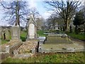
Graveyard Of The Parish Church of St. Michael the Archangel
by
Rude Health
geograph for square
SP0299
Tags:
top:
Burial Ground, Crematorium
X
subject:
Graveyard
X
top:
Lowlands
X
Parish Church of St. Michael the Archangel
X
top:
Religious Sites
X
place:
Rushall
View more in the Image Search
or
in Browser
View images matching 'Rushall' anywhere
in
the tags
Don't click these:
PotMel 1
PotMel 2
☰
Home
View
Search
Marked Images
Maps
Browser
Explore
Showcase
New Images
Collections
Interact
Games
Discussions
Blog
Contributors
Submit
Statistics
Leaderboards
General
FAQ
Help Pages
Sitemap
Contact Us
Support Us
sponsored by
🔍
What to search:
Photos
Enter keywords or a location/postcode to search nearby images
Enter a Grid Reference
Placenames
Collections
Website Pages
Everything
Others:
Advanced Search
|
Image Browser
Or:
Coverage Map
|
Searchable Map
You are not logged in
login
|
register