Public Tags
Tag: Portpatrick
Other tags: place:Portpatrick
railway:Portpatrick
Showing images tagged with Portpatrick tag.
|
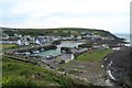
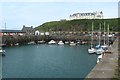
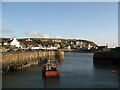
Portpatrick Harbour
by Adrian Taylor geograph for square NW9954 Portpatrick is at the start of The Southern Upland Way.
Tags:
top:CoastalX
top:Docks, HarboursX
Dumfries and GallowayX
type:GeographX
subject:HarbourX
Inner HarbourX
PortX
Portpatrick
place:PortpatrickX
Southern Upland WayX
VillageX
WigtownshireX
|
|
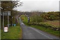
Viaduct, Portree
by Richard Webb geograph for square NX0053 The Portpatrick Railway, aka The Port Road, or Paddy crossed a minor road just... (more)
Tags:
top:Derelict, DisusedX
type:GeographX
railway:PortpatrickX
railway:Portpatrick and WigtownshirX
railway:PPKX
top:RailwaysX
top:Roads, Road TransportX
ViaductX
|
|
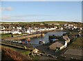
View across Portpatrick from the North west
by Graham Robson geograph for square NW9954 Looking across Portpatrick from the footpath which the Southern Upland Way... (more)
|
|
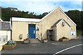
Portpatrick Village Hall
by Graham Robson geograph for square NW9954 The village hall on Welsh Place, near the harbour, in Portpatrick.
|
|
Portpatrick Harbour
by Graham Robson geograph for square NW9954 A variety of small pleasure craft are tied up in the harbour at Portpatrick.
|
|
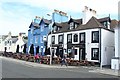
Harbour side pubs, Portpatrick
by Graham Robson geograph for square NW9954 A couple of adjacent pubs with frontages looking out across the harbour in Portpatrick.
|
|
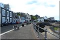
South Crescent, Portpatrick
by Graham Robson geograph for square NW9954 Looking along South Crescent in Portpatrick with the houses facing onto harbour.
|
|
North Crescent and The Harbour House Hotel
by Adrian Taylor geograph for square NW9954 Dominated by The Portpatrick Hotel on the cliff top above the town, North... (more)
Tags:
Bench MarkX
BenchmarkX
top:CoastalX
top:Docks, HarboursX
type:GeographX
HotelX
Ordnance Survey Bench MarkX
Ordnance Survey BenchmarkX
place:PortpatrickX
subject:PromenadeX
RailingsX
top:Roads, Road TransportX
top:Rocks, Scree, CliffsX
Winter SunX
|
|
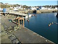
Floating pontoon, Portpatrick Harbour
by Adrian Taylor geograph for square NW9954 There is an Ordnance Survey rivet benchmark with cut mark arrow visible on the... (more)
Tags:
BuoysX
Cut Benchmark with RivetX
Cut Mark with RivetX
top:Docks, HarboursX
top:Estuary, MarineX
Floating PontoonX
type:GeographX
subject:HarbourX
Harbour WallX
top:Historic Sites and ArtefactsX
Ordnance SurveyX
Ordnance Survey Bench MarkX
Ordnance Survey BenchmarkX
PortX
Portpatrick
place:PortpatrickX
QuayX
Rivet Bench MarkX
RopeX
|
|
New Harbour, Portpatrick
by Adrian Taylor geograph for square NW9954 At one time the main embarkation point for Ireland it is many years since the... (more)
Tags:
top:CoastalX
top:Docks, HarboursX
Fishing BoatX
type:GeographX
subject:HarbourX
PortX
place:PortpatrickX
Portpatrick
QuayX
|
|
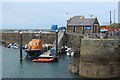
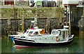
Lifeboat Station, Portpatrick
by Graham Robson geograph for square NW9954 A Royal National Lifeboat Institution lifeboat station in the harbour of... (more)
|
|
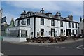
The Harbour House Hotel, Portpatrick
by Graham Robson geograph for square NW9954 A large pub with views overlooking the harbour in Portpatrick.
Tags:
top:Business, Retail, ServicesX
type:GeographX
place:PortpatrickX
PubX
Public HouseX
top:Village, Rural SettlementX
|
|
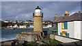
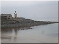
Portpatrick lighthouse
by Ian Taylor geograph for square NW9953 On the south side of the harbour mouth.
The harbour, lighthouse and associated... (more)
|
|
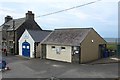
Public toilets, Portpatrick
by Graham Robson geograph for square NW9954 A small building housing public toilets. The adjacent building is a base for the... (more)
Tags:
Coastguard StationX
type:GeographX
place:PortpatrickX
top:Public Buildings and SpacesX
Public ToiletsX
|
|
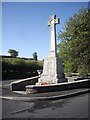
War Memorial, Portpatrick
by Stanley Howe geograph for square NX0054 At the junction of Haugh Road with the A77.
Tags:
road:A77X
Junction of A-Road and Minor RoadX
place:PortpatrickX
top:Suburb, Urban FringeX
War Memorial WW1 and WW2X
|
|
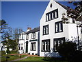
Front garden, Dunskey Guest House
by Stanley Howe geograph for square NX0054 Haugh Road, Portpatrick.
|
|
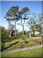
Terraced lawn, Dunskey Guest House
by Stanley Howe geograph for square NX0054 On Heugh Road, Portpatrick.
Tags:
Front GardenX
Guest HouseX
Hotel Name SignX
LawnX
place:PortpatrickX
top:Suburb, Urban FringeX
|
|
Dunskey Guest House
by Stanley Howe geograph for square NX0054 Portpatrick.
|
|
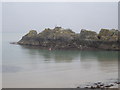
Dorn Rock, Portpatrick Harbour
by Stanley Howe geograph for square NW9954 With its stmbolic flagpole and anchor regularly maintained by the civic authority.
|
|
Portpatrick Lighthouse (disused)
by Stanley Howe for square NW9953 Seen across the harbour from the North Crescent.
|
|
The "Portamaggie" at Portpatrick
by Albert Bridge for square NW9954 Category: Lifeboat (former) The Portamaggie was a Rother class lifeboat built in 1979 and formerly on... (more)
|
|
Corner of The Harbour House Hotel
by Adrian Taylor for square NW9954 Detail of the corner of The Harbour House Hotel on the junction of North... (more)
|
|
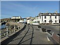
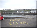
Keep Clear
by Stanley Howe geograph for square NW9953 Jetty space on the South pier car park; looking NW towards the Portpatrick Hotel... (more)
Tags:
CarparkX
top:City, Town CentreX
top:Estuary, MarineX
GullsX
HarboursideX
JettyX
place:PortpatrickX
|
|
Mill Isle, Galdenoch
by Stanley Howe geograph for square NW9862 By B738.
|
|
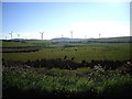
View towards Craigenlee Wind Farm
by Stanley Howe geograph for square NX0056 From B738 near New Loch.
|
|
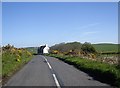
Approach to Auchenree junction
by Stanley Howe geograph for square NX0057 On A938 from Kirkpatrick.
|
|
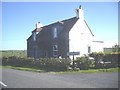
Auchenree Cottage on B738
by Stanley Howe geograph for square NX0057 At the junction for Low Auchenree.
|
|
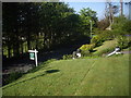
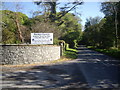
Entrance to Dunskey House estate
by Stanley Howe geograph for square NX0055 Off the A723; with a notice board detailing the estate's visitor attractions.
|
|
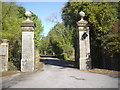
Lodge Gate and entrance to Dunskey House
by Stanley Howe geograph for square NX0055 The driveway leads also through woodland to a walled garden.
|
|
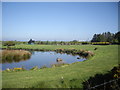
View to Galdenoch Radio Station
by Stanley Howe geograph for square NW9862 Over the Mill Isle pond, from the B738.
|
|
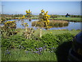
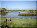
Hybrid mallard (Cayugas) by Galdenoch pond
by Stanley Howe geograph for square NW9862 By B738.
Tags:
B738X
IsletX
top:Lakes, Wetland, BogX
Mallard DucksX
PondX
place:PortpatrickX
top:Wild Animals, Plants and MushroomsX
|