Public Tags
Showing images tagged with postcode district:B44 tag.

|
Deeper Life Bible Church, 401-403 King's Road, Kingstanding, north Birmingham
by Robin Stott
geograph for square SP0894
On a map of 1937 this is a vacant narrow site between semi-detached houses. A... (more)
|
|
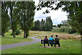
Top of Finchley Park, Kingstanding, north Birmingham
by Robin Stott
geograph for square SP0894
It says Finchley Park at the entrance on King's Road behind the camera. The... (more)
|
|
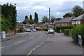
West end of Tottenham Crescent, New Oscott, Birmingham
by Robin Stott
geograph for square SP0894
The land falls to the valley of a brook that flows out of Sutton Park SP0995... ( more) |
|
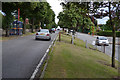
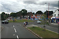
Split-level stretch of King's Road, between Kingstanding and New Oscott, Birmingham
by Robin Stott
geograph for square SP0994
King's Road is running obliquely along the flank of a ridge. This is near... (more)
|
|
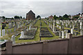
Birmingham Hebrew Congregation Cemetery, Warren Road, Witton
by Robin Stott
geograph for square SP0892
The view is from a northbound 907 bus on College Road. Another view is... (more)
|
|
Shops on College Road, Kingstanding, north Birmingham
by Robin Stott
geograph for square SP0893
The junction is with Dovedale Road, left, and Brackenbury Road, right. The view... (more)
|
|
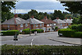
East end of Tottenham Crescent, New Oscott, north Birmingham
by Robin Stott
geograph for square SP0994
The view is across the split-level dual carriageway of King's Road from a... (more)
|