Public Tags
Showing latest 50 of 93 images tagged with postcode district:CV35 tag.
|
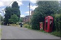
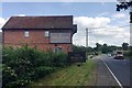
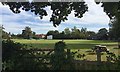
Postbox, phone box and cottages, Mill Lane, Little Shrewley
by Robin Stott geograph for square SP2267 The postbox ID is CV35 122.
Tags:
top:CommunicationsX
postcode district:CV35
type:GeographX
near:HattonX
place:Little ShrewleyX
top:LowlandsX
near:ShrewleyX
top:Village, Rural SettlementX
|
|
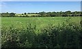
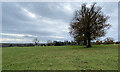
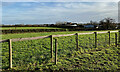
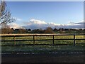
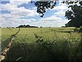
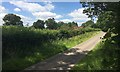
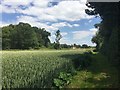
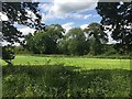
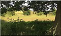
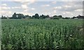
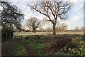
Crops and hedgerows northwest of Warwick
by Robin Stott geograph for square SP2766 The view is from the unnamed road that continues north from Wedgnock Lane. The... (more)
|
|
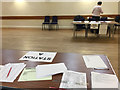
Leek Wootton village hall arranged as a double polling station
by Robin Stott for square SP2869 The occasion was the General Election held on 8th June 2017. Elections are run... (more)
Tags:
postcode district:CV35
DocumentsX
ElectionX
type:InsideX
place:Leek WoottonX
top:LowlandsX
top:People, EventsX
Village HallX
top:Village, Rural SettlementX
near:WarwickX
|
|
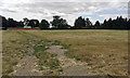
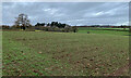
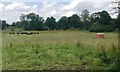
Grounds of Watchbury Hill across a field
by Robin Stott geograph for square SP2860 The house appears to occupy extensive woodland on the summit of the hill. The... (more)
|
|
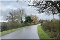
Northeast on Finwood Road, Turner's Green
by Robin Stott geograph for square SP1970 Looking towards the junction with the Old Warwick Road B4439 and Rowington Green... (more)
Tags:
ArdenX
Country RoadX
postcode district:CV35
type:GeographX
top:LowlandsX
top:Roads, Road TransportX
near:Rowington GreenX
near:Turners GreenX
top:Village, Rural SettlementX
|
|
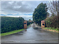
Gates to Windmill Cottage, Turner's Green
by Robin Stott geograph for square SP1969 An entrance on Finwood Road. Old maps show Windmill House here and a circular... (more)
Tags:
ArdenX
postcode district:CV35
type:GeographX
top:Housing, DwellingsX
Large Detached HouseX
top:LowlandsX
near:RowingtonX
place:Turners GreenX
top:Village, Rural SettlementX
|
|
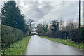
Southwest on Finwod Road
by Robin Stott geograph for square SP1969 Finwood Road turns south from the Old Warwick Road for Turner's Green,... (more)
Tags:
ArdenX
Country RoadX
postcode district:CV35
type:GeographX
top:LowlandsX
top:Roads, Road TransportX
near:RowingtonX
place:Turners GreenX
|
|
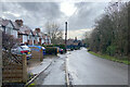
Approaching Turner's Green
by Robin Stott geograph for square SP1969 Finwood Road drops down into the canalside hamlet.
Tags:
postcode district:CV35
type:GeographX
near:Grand Union CanalX
top:LowlandsX
place:Turners GreenX
top:Village, Rural SettlementX
|
|
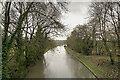
Canal southeast of Rowington
by Robin Stott geograph for square SP2069 The Grand Union Canal is carried on a massive embankment southeast of Rowington... (more)
|
|
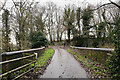
Rowington Hill Bridge
by Robin Stott geograph for square SP2069 The bridge carries a track and the Heart of England Way from Rowington village... (more)
Tags:
top:CanalsX
postcode district:CV35
type:GeographX
canal:Grand Union CanalX
path:Heart of England WayX
top:LowlandsX
bridge:Path Over CanalX
place:RowingtonX
top:Village, Rural SettlementX
|
|
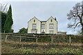
The Old Vicarage, Rowington
by Robin Stott geograph for square SP2069 Not a listed building.
Tags:
postcode district:CV35
type:GeographX
top:Housing, DwellingsX
Large Detached HouseX
top:LowlandsX
place:RowingtonX
top:Village, Rural SettlementX
|
|
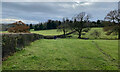
Approaching Rowington
by Robin Stott geograph for square SP2069 The Heart of England Way runs beside dense hedges. The tower of the church of St... (more)
Tags:
top:Boundary, BarrierX
postcode district:CV35
top:Farm, Fishery, Market GardeningX
type:GeographX
path:Heart of England WayX
top:LowlandsX
near:RowingtonX
Winter FieldsX
|
|
Missing hedge near Rowington
by Robin Stott geograph for square SP2069 The isolated trees, right, mark the line of a hedge shown on the 2015 1:25,000... (more)
Tags:
postcode district:CV35
top:Farm, Fishery, Market GardeningX
type:GeographX
path:Heart of England WayX
top:LowlandsX
near:RowingtonX
Winter FieldsX
|
|
Towards Rowington Green
by Robin Stott for square SP2070 Looking north from the Heart of England Way, left of centre are the tall pines... (more)
Tags:
type:Cross GridX
postcode district:CV35
top:Farm, Fishery, Market GardeningX
path:Heart of England WayX
top:LowlandsX
near:RowingtonX
near:Rowington GreenX
Winter FieldsX
|
|
Arden countryside near Rowington
by Robin Stott geograph for square SP2069 The view is northeast from the Heart of England Way towards Wroxall.
Tags:
postcode district:CV35
top:Farm, Fishery, Market GardeningX
type:GeographX
path:Heart of England WayX
top:LowlandsX
near:RowingtonX
near:Rowington GreenX
Winter FieldsX
|
|
Rowington Mill, Rowington Green
by Robin Stott geograph for square SP2070 A former windmill has been converted and extended as a private house. There are... (more)
Tags:
postcode district:CV35
type:GeographX
top:Housing, DwellingsX
Large Detached HouseX
top:LowlandsX
place:Rowington GreenX
top:Village, Rural SettlementX
former:WindmillX
|
|
Quarry Farm, Rowington Green
by Robin Stott geograph for square SP2070 The view is from the Heart of England Way.
Tags:
postcode district:CV35
Farm BuildingsX
top:Farm, Fishery, Market GardeningX
type:GeographX
top:LowlandsX
place:Rowington GreenX
top:Village, Rural SettlementX
|
|
Rowington Mill, Rowington Green
by Robin Stott geograph for square SP2070 A former windmill has been converted and extended as a private house. There are... (more)
Tags:
postcode district:CV35
type:GeographX
top:Housing, DwellingsX
Large Detached HouseX
top:LowlandsX
place:Rowington GreenX
top:Village, Rural SettlementX
former:WindmillX
|
|
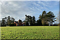
A wintry shower over Warwick
by Robin Stott geograph for square SP2867 The view south from the Warwickshire Golf and Country Club car park that became... (more)
Tags:
top:Air, Sky, WeatherX
postcode district:CV35
type:GeographX
Golf CourseX
near:Leek WoottonX
top:LowlandsX
Shower CloudX
top:Village, Rural SettlementX
near:WarwickX
season:WinterX
|
|
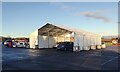
Drive-thru vaccination centre, Warwickshire Golf and Country Club, Leek Wootton
by Robin Stott for square SP2868 This was organised by local GP practices: cheerful vaccinators, helpful stewards... (more)
Tags:
Coronavirus - Covid 19X
type:Cross GridX
postcode district:CV35
Drive ThroughX
Drive ThruX
Golf ClubX
top:Health and Social ServicesX
near:Leek WoottonX
top:LowlandsX
PandemicX
top:Sport, LeisureX
Vaccination CentreX
top:Village, Rural SettlementX
near:WarwickX
|

|
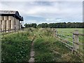
Tracks and drives, Hatton Green
by Robin Stott geograph for square SP2367 |
|
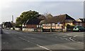
The Falcon Inn, Haseley, from the north
by Robin Stott geograph for square SP2367 'Restaurant, Country Pub, Hotel' proclaims the sign. Beside the A4177... (more)
|
|
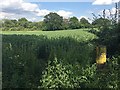
Footpath and tramlines through a field of wheat, Haseley
by Robin Stott geograph for square SP2267 Just behind the camera is Stoney Lane, in Shrewley civil parish SP2267 : Northwest on Stoney Lane, Little Shrewley. The... (more)
|
|
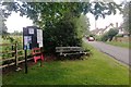
Community corner, Little Shrewley
by Robin Stott geograph for square SP2267 At the corner of Mill Lane, right, and Croft Lane behind the camera. A patch of... (more)
Tags:
ArdenX
postcode district:CV35
type:GeographX
Grass VergeX
near:Hatton GreenX
place:Little ShrewleyX
top:LowlandsX
NoticeboardX
near:ShrewleyX
Shrewley ParishX
top:Village, Rural SettlementX
|
|
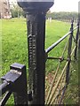
Cast iron gate post, Haseley parish churchyard, Firs Lane
by Robin Stott for square SP2368 The churchyard is bounded by a pleasing cast iron and wrought iron fence. A... (more)
Tags:
top:Boundary, BarrierX
material:Cast IronX
type:Close LookX
postcode district:CV35
Gate PostX
place:HaseleyX
fence:Iron Post and RailX
top:LowlandsX
top:Religious SitesX
|
|
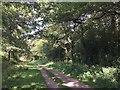
Northwest on Stoney Lane, Little Shrewley
by Robin Stott geograph for square SP2267 It's interesting that the continuation of Stoney Lane becomes Quarry Lane... (more)
|
|
Moonpiece Barn and a field of bales
by Robin Stott geograph for square SP2266 Station Road runs across the picture. A bird seems to be flying towards the camera.
Tags:
ArdenX
postcode district:CV35
top:Farm, Fishery, Market GardeningX
FarmlandX
type:GeographX
near:Hatton StationX
Hedgerow OaksX
top:LowlandsX
|
|
Fields east of Station Road, Little Shrewley
by Robin Stott geograph for square SP2267 A grass crop has been taken. Traffic on the B4439 Hockley Road can be seen on the left.
Tags:
ArdenX
postcode district:CV35
top:Farm, Fishery, Market GardeningX
type:GeographX
Grass FieldsX
Hedgerow OaksX
near:Little ShrewleyX
top:LowlandsX
|
|
Timber-framed house with extensions, Station Road, Little Shrewley
by Robin Stott geograph for square SP2267 A house named Thrackum according to a sign by the door. Historic England know it... (more)
Tags:
ArdenX
postcode district:CV35
type:GeographX
near:Hatton StationX
top:Housing, DwellingsX
place:Little ShrewleyX
top:LowlandsX
house:Timber-FramedX
top:Village, Rural SettlementX
|
|
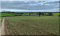
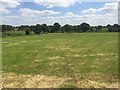
Corner of a wheatfield near Hatton Wood
by Robin Stott geograph for square SP2367 The footpath through fields leads to Hatton Green.
|
|
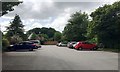
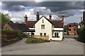
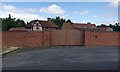
Car park of the Anchor Inn, Leek Wootton
by Robin Stott geograph for square SP2868 Tags:
top:Business, Retail, ServicesX
Car ParkX
postcode district:CV35
type:GeographX
place:Leek WoottonX
top:LowlandsX
PubX
top:Roads, Road TransportX
top:Village, Rural SettlementX
near:WarwickX
|
|
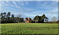
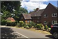
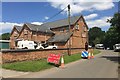
Barford Village Hall, Church Street
by Robin Stott geograph for square SP2760 The village shop occupies the far end of the building. There is a car park to... (more)
Tags:
place:BarfordX
postcode district:CV35
type:GeographX
top:LowlandsX
top:Public Buildings and SpacesX
Village HallX
top:Village, Rural SettlementX
|
|
Western perimeter of Rowington Coppice
by Robin Stott geograph for square SP2070 The Heart of England way follows this track. The gate into Rowington Coppice is... (more)
Tags:
postcode district:CV35
Deciduous WoodlandX
type:GeographX
Long Distance PathX
top:LowlandsX
top:PathsX
near:Rowington GreenX
top:Woodland, ForestX
|
|
Rowington Cricket Club ground, Rowington Green
by Robin Stott for square SP2070 No cricket on this occasion but there was a wedding reception in full swing in... (more)
Tags:
ArdenX
type:Cross GridX
postcode district:CV35
near:KingswoodX
top:LowlandsX
near:RowingtonX
place:Rowington GreenX
top:Sport, LeisureX
top:Village, Rural SettlementX
|
|
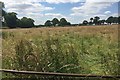
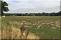
Mown meadow and field boundary, Haseley
by Robin Stott geograph for square SP2368 |
|
The Mill, Mill Lane, Little Shrewley
by Robin Stott geograph for square SP2267 The building is divided into nine business units. It takes its name from the... (more)
Tags:
top:Business, Retail, ServicesX
postcode district:CV35
former:Farm BuildingsX
type:GeographX
near:Hatton GreenX
place:Little ShrewleyX
top:LowlandsX
Rural Business CentreX
near:ShrewleyX
top:Village, Rural SettlementX
|
|
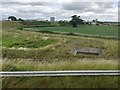
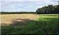
Crop and drainage at Longbridge near Warwick
by Robin Stott geograph for square SP2662 Longbridge is the local name for the six-way interchange at junction 15 of the... (more)
|
|
Northern part of Haseley Springs
by Robin Stott geograph for square SP2368 Haseley Springs is a source of groundwater, believed to consist of underground... (more)
|
|
Southern part of Haseley Springs
by Robin Stott geograph for square SP2368 Haseley Springs is a source of groundwater, consisting of underground gravel... (more)
|
|
The Anchor Inn, Warwick Road, Leek Wootton
by Robin Stott geograph for square SP2868 The rear of the pub from the steep car park. Not a listed building.
Tags:
top:Business, Retail, ServicesX
postcode district:CV35
type:GeographX
place:Leek WoottonX
top:LowlandsX
Public HouseX
top:Village, Rural SettlementX
near:WarwickX
|
|
Hay Wood and Rowington Coppice
by Robin Stott geograph for square SP2070 The view shows part of the west side of Hay Wood. It's huge for... (more)
Tags:
Arable FieldX
near:Baddesley ClintonX
woodland:BroadleafX
postcode district:CV35
top:Farm, Fishery, Market GardeningX
type:GeographX
top:LowlandsX
woodland:MixedX
near:Rowington GreenX
top:Woodland, ForestX
|
|
Bridleway by Lyons Farm, Rowington Green
by Robin Stott geograph for square SP2070 This is the route of the Heart of England Way going north from the Rowington... (more)
Tags:
ArdenX
woodland:BroadleafX
postcode district:CV35
Dutch BarnX
top:Farm, Fishery, Market GardeningX
FarmlandX
type:GeographX
Long Distance PathX
top:LowlandsX
top:PathsX
place:Rowington GreenX
Straw BalesX
top:Woodland, ForestX
|
|
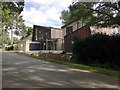
Two bespoke modern houses, Rowington Green
by Robin Stott geograph for square SP1970 The further of the two is advertised for sale at £1,000,000, "A wonderful... (more)
Tags:
ArdenX
postcode district:CV35
type:GeographX
top:Housing, DwellingsX
top:LowlandsX
Luxury HousesX
Modern HousesX
New HousesX
place:Rowington GreenX
top:Village, Rural SettlementX
|
|
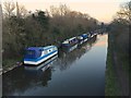
Residential boats, Grand Union Canal near Shrewley
by Robin Stott geograph for square SP2266 Photographed at about 3:30pm in mid-December from a footbridge, bridge 57, seen... (more)
Tags:
Canal BoatsX
top:CanalsX
postcode district:CV35
type:GeographX
canal:Grand UnionX
near:HattonX
top:LowlandsX
ResidentialX
near:ShrewleyX
top:Village, Rural SettlementX
|
|
Beyond the beans Haseley
by Robin Stott geograph for square SP2368 The view is from the Birmingham Road A4177. Haseley is a scatter of buildings,... (more)
Tags:
ArdenX
postcode district:CV35
crop:Field BeansX
type:GeographX
place:HaseleyX
near:Hatton GreenX
top:LowlandsX
top:Village, Rural SettlementX
|
|
Looking northwest towards Coffeepot Lane, Little Shrewley
by Robin Stott geograph for square SP2267 A pleasant, quiet countryside notable for footpath diversions.
|
|
A public footpath crosses a field of beans, Haseley
by Robin Stott geograph for square SP2268 The next waymarker is beneath the big oak, centre. The field is huge: an... (more)
Tags:
postcode district:CV35
top:Farm, Fishery, Market GardeningX
crop:Field BeansX
type:GeographX
place:HaseleyX
near:Hatton GreenX
top:LowlandsX
top:PathsX
|
|
Turf nursery between the railway and the M40 near Great Pinley
by Robin Stott geograph for square SP2166 Seen in 2010: SP2166 : Machine on a turf nursery. The railway and the canal run parallel in the shallow... (more)
|
|
A very private property southwest of Shrewley
by Robin Stott geograph for square SP2167 Historic England knows the timber-framed building as The Gatehouse, formerly the... (more)
Tags:
postcode district:CV35
type:GeographX
Large Detached HouseX
top:LowlandsX
place:ShrewleyX
house:Timber-FramedX
top:Village, Rural SettlementX
|
|
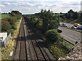
Railway and motorway in parallel southeast of Finwood Road, Turners Green
by Robin Stott geograph for square SP1968 When approaching this stretch of line, Birmingham-bound trains (coming towards... (more)
Tags:
postcode district:CV35
Former GWRX
type:GeographX
top:LowlandsX
near:LowsonfordX
motorway:M40X
top:RailwaysX
top:Roads, Road TransportX
near:Turners GreenX
|