Public Tags
Tag: Refuge
Showing images tagged with Refuge tag.
|
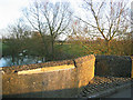
Refuge and damage on Ickford Bridge -- 2008
by John S Turner geograph for square SP6406 The ancient Ickford Bridge has a triangular refuge on both sides of the road... (more)
Tags:
Boundary MarkerX
Boundary StonesX
BridgeX
Damaged BridgeX
top:Historic Sites and ArtefactsX
milestoneid:OX TIDD01cbX
Refuge
RiverX
top:Roads, Road TransportX
|
|
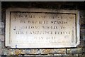
Site of the Cambridge Refuge
by Tiger for square TL4558 A survival in a back alley behind Christ Church: "This wall and the ground... (more)
|
|
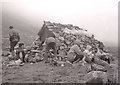
Garbh Choire Refuge
by Richard Sutcliffe for square NN9598 Members of Aberdeen Mountaineering Club have a rest beside the refuge.
The... (more)
|
|
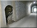
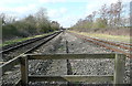
Refuge inside Swainsley Tunnel
by Stephen Craven for square SK0957 Refuges like this were built for railway workers to dodge into when a train... (more)
|
|
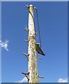
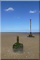
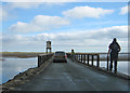
Refuge pole on the beach east of Horse Shoe Point
by David Lally for square TA3902 |
|
The refuge pole
by David Lally geograph for square TA3902 With the base of a previous one. I would guess that there must have been in the... (more)
|
|
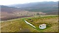
Mountain Refuge Hut below The Cheviot
by Alan O'Dowd geograph for square NT8720 This refuge at the top of Auchope Rig is maintained by the Northumberland... (more)
|
|
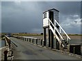
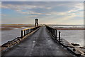
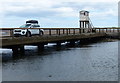
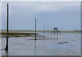
Refuge on the causeway
by Pauline E geograph for square NU0842 The tide has just ebbed far enough to allow the traffic on and off Holy Island.... (more)
|
|
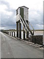
A refuge hut on Lindisfarne Causeway
by Walter Baxter geograph for square NU0842 Holy Island is linked to the mainland by a long causeway where twice each day... (more)
|
|
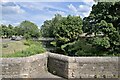
Refuge, River, and Footbridge
by Bob Harvey geograph for square TF1509 Looking downstream from the upstream side of the Bridge, showing one of the... (more)
Tags:
subject:BridgeX
Bridge ParapetX
place:Deeping GateX
place:Deeping St JamesX
top:Flat LandscapesX
type:GeographX
Grade II(star) ListedX
Refuge
subject:RiverX
top:Rivers, Streams, DrainageX
Scheduled Ancient MonumentX
top:Suburb, Urban FringeX
The DeepingsX
river:WellandX
Welland BridgesX
|
|
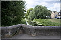
River and Refuge
by Bob Harvey geograph for square TF1509 The cutwaters of the bridge piers are echoed as small triangular refuges in the... (more)
Tags:
date:1651X
period:17th CenturyX
road:B1162X
subject:BridgeX
Bridge ParapetX
place:Deeping GateX
top:Flat LandscapesX
type:GeographX
Grade II (Star)X
Refuge
subject:RiverX
top:Rivers, Streams, DrainageX
top:Roads, Road TransportX
Scheduled Ancient MonumentX
top:Suburb, Urban FringeX
The DeepingsX
river:WellandX
Welland BridgesX
|
|
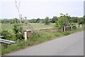
The remains of the causeway
by Bob Harvey geograph for square SP8491 In a couple of places to the North of SP8491 : Bridge over the Welland are these semicircular... (more)
Tags:
period:18th CenturyX
subject:CausewayX
near:CottinghamX
type:GeographX
Grade II ListedX
top:LowlandsX
Refuge
river:River WellandX
top:Rivers, Streams, DrainageX
top:Roads, Road TransportX
Welland BridgesX
|
|
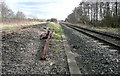
Refuge
by Mick Garratt geograph for square NN7061 Near Mullinavadie.
|
|
Holy Island Sands
by Chris Heaton geograph for square NU0942 From the causeway, the view looks over Holy Island Sands towards a line of posts... (more)
|
|
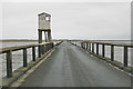
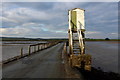
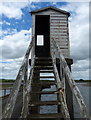
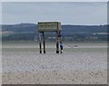
Refuge Box on Lindisfarne Causeway (2)
by Chris Heaton geograph for square NU0842 This is for person or persons caught out by a rising tide. For pedestrians it is... (more)
|
|
Refuge Box on Lindisfarne Causeway (1)
by Chris Heaton geograph for square NU0842 Approaching from the mainland as the road crosses South Low.
This is for person... (more)
|
|
Walking over the causeway
by Pauline E geograph for square NU0842 There is also a marked walking route over the sands and mud, best tackled with a... (more)
|
|
Towards Birmingham
by Graham Horn geograph for square SP6814 There are two "stop, look and listen" warnings here, as you cross each... (more)
|
|
Towards London
by Graham Horn geograph for square SP6814 There are two "stop, look and listen" warnings here, as you cross each... (more)
|
|
Crossing point on the C2C
by Oliver Dixon geograph for square NZ1751 Refuge in the centre of Durham Road (B6168), Annfield Plain to provide a safe... (more)
Tags:
B RoadX
subject:CrossingX
Disused RailwayX
top:Educational SitesX
type:GeographX
Junior SchoolX
National Cycle NetworkX
top:PathsX
top:RailwaysX
Refuge
top:Roads, Road TransportX
|
|
Refuge on the Lindisfarne Causeway
by Mat Fascione geograph for square NU0842 Tags:
CausewayX
top:CoastalX
top:Estuary, MarineX
type:GeographX
place:LindisfarneX
Refuge
top:Roads, Road TransportX
|
|
Refuge on the Lindisfarne Causeway
by Mat Fascione geograph for square NU0842 |
|
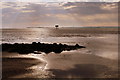
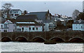
High tide at Wadebridge
by Derek Harper geograph for square SW9972 A detail of the view in SW9972 : The Old Bridge, Wadebridge, with the entire island submerged, save for... (more)
|
|
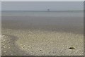
Cockle shells collected together
by Russel Wills geograph for square NU1042 On Holy Island Sands.
Refuge and guide posts for pilgrims in the distance.
|
|
Refuge on the Lindisfarne Causeway
by M J Richardson geograph for square NU0842 Apparently people get caught out about once a month.
Tags:
near:BealX
CausewayX
top:CoastalX
top:Estuary, MarineX
type:GeographX
top:Health and Social ServicesX
place:LindisfarneX
place:NorthumberlandX
Refuge
top:Roads, Road TransportX
subject:ShelterX
|
|
Refuge on the line of posts
by Russel Wills geograph for square NU1042 In case you are caught on a rising tide!
|
|
Pilgrims or hikers check the refuge
by Russel Wills geograph for square NU0842 On the line of posts marking the traditional way to get to Holy Island.
|
|
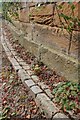
Edging Bricks to the Driveway
by Mick Garratt for square NZ6519 Here on the 18th century bridge NZ6519 : Bridge, Skelton Castle. These bricks are made of scoria,... (more)
Tags:
BricksX
subject:Building DetailX
Building MaterialX
top:Country EstatesX
DrossX
bucket:InformativeX
Iron SmeltingX
Refuge
top:Roads, Road TransportX
ScoriaX
SlagX
WasteX
|