Public Tags
Tag: Remote
Showing images tagged with Remote tag.
|
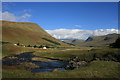
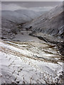
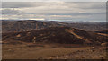
Glen Lyon
by I Love Colour for square NN4641 Looking east across along Glen Lyon at Pubil, Aberfeldy near the head of Loch... (more)
Tags:
place:Central ScotlandX
ClimbingX
CyclingX
Cycling TrailX
place:Glen LyonX
HikingX
LochX
subject:LochX
place:Loch LyonX
MoorlandX
top:MoorlandX
MountainX
subject:MountainX
Mountain RidgeX
Mountain SceneX
Mountain SlopesX
Mountain ViewX
Mountain WalkerX
MunroX
Munro MountainsX
MunrosX
Remote
Remote AreaX
Remote DwellingX
RiverX
River LyonX
top:Rivers, Streams, DrainageX
place:ScotlandX
top:Sport, LeisureX
top:UplandsX
WalkingX
top:Water ResourcesX
|
|
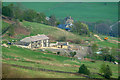
View towards Broad Head End
by Phil Champion geograph for square SD9925 A remote house above Cragg Vale. Viewed from the edge of Erringden Moor. It... (more)
Tags:
Broad Head EndX
place:CalderdaleX
place:Cragg ValeX
top:GrasslandX
HouseX
top:LowlandsX
Remote
Remote DwellingX
top:Village, Rural SettlementX
|
|
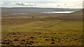
Southern Slopes of Ben Griam Beg and Achentoul Forest, Sutherland
by Andrew Tryon geograph for square NC8440 View facing south of the southern slopes of Ben Griam Beg, looking over the... (more)
|
|
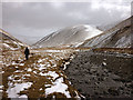
Beside Langdale Beck
by Karl and Ali geograph for square NY6502 In places there is a shepherd's track to aid progress along this superbly... (more)
|
|
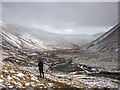
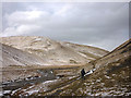
Langdale, the Howgill Fells
by Karl and Ali geograph for square NY6601 Having abandoned our plan to gain the ridge above we decided to descend into... (more)
Tags:
top:Air, Sky, WeatherX
DaleX
FellsX
top:MoorlandX
Remote
top:Rivers, Streams, DrainageX
Thin Snow CoverX
top:UplandsX
|
|
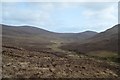
Upper Glen Sletdale, Sutherland
by Andrew Tryon geograph for square NC8915 The upper reaches of Glen Sletdale, an uninhabited valley in the northern... (more)
Tags:
CountrysideX
type:GeographX
place:Glen SletdaleX
top:MoorlandX
Remote
place:ScotlandX
place:Scottish HighlandsX
place:SutherlandX
place:UKX
UnspoiledX
top:UplandsX
subject:ValleyX
WildernessX
|
|
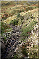
Rocks below Natty Bridge
by Andy Deacon geograph for square SD2494 Looking down from Natty Bridge at Yewry Sike before it flows into River Lickle.
Tags:
county:CumbriaX
national park:Lake DistrictX
top:PathsX
Remote
River LickleX
top:Rivers, Streams, DrainageX
top:UplandsX
|
|
Land near Natty Bridge
by Andy Deacon geograph for square SD2494 View towards the River Lickle Valley and Duddon Estuary.
Tags:
Autumn ColoursX
AutumnalX
Early Autumn ColourX
national park:Lake DistrictX
Remote
River LickleX
top:UplandsX
ValleyX
|
|
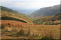
Langdale in 'Spring'!
by Karl and Ali geograph for square NY6501 An icy breeze is funnelling down the valley but the only shelter is nearby... (more)
|
|
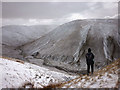
Overlooking Langdale, the Howgill Fells
by Karl and Ali geograph for square NY6601 A freezing easterly gale is sweeping across the exposed summits and so we have... (more)
|
|
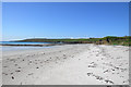
Backaskaill Bay, Sanday, Orkney
by Peter Amsden geograph for square HY6439 Category: Coast Looking West.
|
|
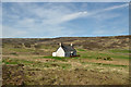
Brae Cottage in Strath Carnaig, Sutherland
by Andrew Tryon geograph for square NH7098 An isolated house viewed from the Loch Buidhe road in Strath Carnaig, Scottish Highlands.
|
|
Maolanaidh Mor, Sutherland
by Andrew Tryon geograph for square NH7196 A view over the empty moorland landscape of East Sutherland in the northern... (more)
Tags:
Barren MoorsX
British MoorlandsX
British UplandsX
type:GeographX
place:Great BritainX
IsolatedX
top:MoorlandX
subject:MoorlandX
Remote
place:ScotlandX
place:Scottish HighlandsX
top:UplandsX
|
|
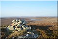
Summit of Creag Riabhach (Stripey Hill), Sutherland
by Andrew Tryon geograph for square NC7112 A small cairn marks the summit of Creag Riabhach (312 m, 1023 ft). The Gaelic... (more)
|
|
Altnabreac Station in the north Highlands
by Andrew Tryon geograph for square ND0045 Altnabreac is one of the remotest and least used train stations in Britain.... (more)
Tags:
place:Altnabreac StationX
British RailX
place:CaithnessX
weather:ColdX
Fresh SnowX
place:Great BritainX
PlatformX
subject:Railway StationX
top:RailwaysX
Remote
place:ScotlandX
ScotRailX
place:Scottish HighlandsX
weather:SnowX
season:WinterX
|
|
Walking down Langdale
by Karl and Ali geograph for square NY6601 The dale is much more sheltered than the exposed summits a few hundred metres... (more)
|