Public Tags
Tag: River·Depth·Gauge
Showing images tagged with River Depth Gauge tag.
|
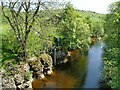
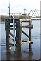
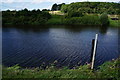
Depth gauge on the Swale by Bridge End House
by Stephen Craven geograph for square NY8801 There was little flow in the river in a fairly dry Spring, but the Swale is... (more)
|
|
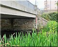
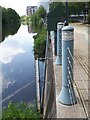
Depth gauge, March Street bridge Peebles
by Jim Barton geograph for square NT2540 A depth gauge for the Eddleston Water on the upstream side of the bridge.
Tags:
river:Eddleston WaterX
type:GeographX
River Depth Gauge
top:Rivers, Streams, DrainageX
Road Bridge Over RiverX
top:Roads, Road TransportX
|
|
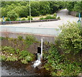
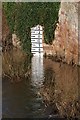
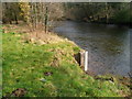
Depth gauge in the West Okement River
by Stephen Craven geograph for square SX5895 The gauge board was reading a minimal 0.2 metres depth; with a weir just... (more)
|
|
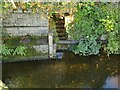
River depth gauge, Merthyr Vale
by Jaggery geograph for square ST0799 The gauge is alongside an outfall through a small stone arch into the River... (more)
|
|
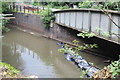
River level recorder, Whitehall Riverside
by Stephen Craven geograph for square SE2933 There is a visual depth gauge as well as equipment to record the level. At this... (more)
|
|
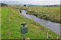
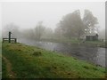
River Rede, Otterburn
by Jim Barton geograph for square NY8892 Looking downstream from the road bridge near the mill. The River Rede joins the... (more)
Tags:
top:Farm, Fishery, Market GardeningX
FarmlandX
type:GeographX
top:GrasslandX
river:RedeX
River Depth Gauge
top:Rivers, Streams, DrainageX
|
|
River depth gauge, River Ayr
by Humphrey Bolton for square NS3621 See also NS3621 : Depth gauge on the bank of the River Ayr. The river overtops its banks during extreme flooding events.
|
|
Depth gauge beside the River Trent
by Graham Hogg geograph for square SK5637 There appeared to be a lot of water in the river after recent heavy rain, but it... (more)
Tags:
place:NottinghamX
River Depth Gauge
River TrentX
top:Rivers, Streams, DrainageX
place:West BridgfordX
|
![SE7622 : Shore mark [navigation beacon], Swinefleet by Christine Johnstone](https://s3.geograph.org.uk/geophotos/03/62/26/3622603_6d96bc5d_120x120.jpg)
|
Shore mark [navigation beacon], Swinefleet
by Christine Johnstone geograph for square SE7622 With depth gauge below. Seen from the barge Sobriety, heading downstream on a... (more)
|
|
River depth gauge, Otley Bridge
by Stephen Craven geograph for square SE2045 After a dry spring the river level at the south bank was only 0.4 metres. Flood... (more)
|
|
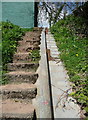
Depth gauge on the bank of the River Ayr
by Humphrey Bolton for square NS3621 The figures are painted on the sloping strip of concrete, looking down towards... (more)
|
|
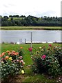
Rose garden beside the River Trent
by Graham Hogg geograph for square SK7046 There can't be many such gardens that have a depth gauge as a feature!
Tags:
subject:GardenX
type:GeographX
place:HoveringhamX
River Depth Gauge
River TrentX
top:Rivers, Streams, DrainageX
Rose GardenX
|
|
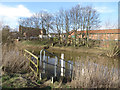
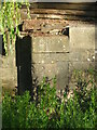
Buildwas gauge
by TCExplorer geograph for square SJ6404 I believe this is a hydrometric river level gauge. There are eight of these here... (more)
Tags:
type:GeographX
subject:River BankX
River Depth Gauge
River SevernX
RiverbankX
top:Rivers, Streams, DrainageX
Water Level GaugeX
|
|
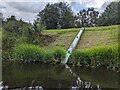
Depth gauge on the Althorpe Jetty
by Graham Hogg geograph for square SE8308 |
|
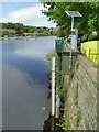
River depth measuring station, River Derwent near Portinscale
by Graham Robson geograph for square NY2523 I assume this equipment on the banks of River Derwent is used to measure the... (more)
|
|
Flood gauge by the River Derwent
by Pauline E geograph for square SE7871 Across the river is the converted mill and to the right, Morrisons supermarket.
|
|
A river depth indicator at Kelso
by Walter Baxter geograph for square NT7233 This indicator marked in feet on the River Tweed was viewed from Kelso Bridge.... (more)
Tags:
River Depth Gauge
top:Rivers, Streams, DrainageX
|
|
River level gauge on the River Wharfe
by Ian S geograph for square SE4744 |
|
River gauge near a water monitoring station, Cwmavon
by Jaggery geograph for square SS7992 Alongside the Afon Afan near this Link water... (more)
Tags:
River Depth Gauge
top:Rivers, Streams, DrainageX
|
|
Coffer dam, River Ebbw, Crumlin
by M J Roscoe geograph for square ST2198 A temporary dam across half of the river to enable repairs to the base of the... (more)
Tags:
top:Boundary, BarrierX
Brick Retaining WallX
place:CrumlinX
subject:DamX
type:GeographX
Railway Bridge Over RiverX
top:RailwaysX
River Depth Gauge
top:Rivers, Streams, DrainageX
Steel ParapetX
top:Suburb, Urban FringeX
Temporary DamX
|
|
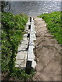
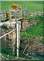
Sluice at the head of the Sea Cut, Everley
by Humphrey Bolton for square SE9788 This controls the flow from the River Derwent to the Sea Cut.
Tags:
type:Close LookX
top:LowlandsX
River Depth Gauge
top:Rivers, Streams, DrainageX
subject:SluiceX
|
|
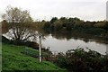
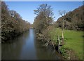
River Tamar at Greystone Bridge
by Derek Harper geograph for square SX3680 A more direct view upstream than SX3680 : River Tamar at Greystone Bridge, from one of the refuges.
Tags:
top:Farm, Fishery, Market GardeningX
top:LowlandsX
MeadowX
River Depth Gauge
top:Rivers, Streams, DrainageX
Riverside TreesX
river:TamarX
long distance path:Tamar Valley Discovery TrailX
WoodX
top:Woodland, ForestX
|
|
Now measuring the weeds
by Neil Owen for square ST5872 The old Bathurst Basin lock gates were removed during WWII, but the elegant late... (more)
Tags:
top:City, Town CentreX
type:Close LookX
top:Docks, HarboursX
top:Historic Sites and ArtefactsX
subject:LockX
River Depth Gauge
|