Public Tags
Tag: River·Lugg
Other tags: river:River Lugg
Showing images tagged with River Lugg tag.
|
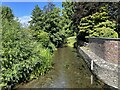
The River Lugg at Lugg Bridge
by Adrian Taylor geograph for square SO3164 The River Lugg forms the international border between Wales (left) and England... (more)
Tags:
top:Boundary, BarrierX
country:EnglandX
Flood DefenceX
Flood Defence WallX
type:GeographX
International BorderX
river:LuggX
PresteigneX
subject:RiverX
River Lugg
top:Rivers, Streams, DrainageX
country:WalesX
|
|
The River Lugg from Dolley Old Bridge
by Jeff Buck geograph for square SO2765 Looking north along the River Lugg from Offa's Dyke Path on Dolley Old... (more)
Tags:
BridgeX
place:Dolley GreenX
FootbridgeX
type:GeographX
river:LuggX
long distance path:Offas DykeX
Offas Dyke PathX
county:PowysX
RiverX
River Lugg
top:Rivers, Streams, DrainageX
country:WalesX
|
|
The River Lugg from Dolley Old Bridge
by Jeff Buck geograph for square SO2765 Looking south along the River Lugg from Offa's Dyke Path on Dolley Old... (more)
Tags:
BridgeX
place:Dolley GreenX
type:GeographX
river:LuggX
long distance path:Offas DykeX
Offas Dyke PathX
county:PowysX
RiverX
River Lugg
top:Rivers, Streams, DrainageX
country:WalesX
|
|
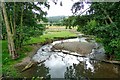
River Lugg from Lyepole Bridge
by Stephen McKay geograph for square SO3965 The River Lugg, seen here looking downstream from Lyepole Bridge, flows for 45... (more)
|
|
River Lugg, Mordiford
by Richard Webb geograph for square SO5637 The main flow of the Lugg here is river left, with a backwater under the old... (more)
Tags:
top:Farm, Fishery, Market GardeningX
type:GeographX
river:River LuggX
top:Rivers, Streams, DrainageX
|
|
River Lugg, Pilleth
by Stephen McKay geograph for square SO2567 The Lugg is a tributary of the Wye, flowing for 45 miles through Radnorshire and... (more)
|
|
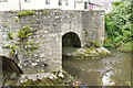
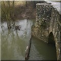
Lugg Bridge
by Stephen McKay geograph for square SO3164 This 17th century bridge over the River Lugg connects Stapleton in Herefordshire... (more)
Tags:
BorderX
top:Boundary, BarrierX
subject:BridgeX
BridgeX
type:GeographX
top:Housing, DwellingsX
River Lugg
top:Rivers, Streams, DrainageX
top:Roads, Road TransportX
|
|
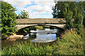
Eaton Bridge
by Richard Webb geograph for square SO5058 The bridge, possibly dating back to the 17th century carries the A44 over the... (more)
Tags:
BridgeX
type:GeographX
river:River LuggX
top:Rivers, Streams, DrainageX
top:Roads, Road TransportX
|
|
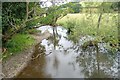
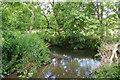
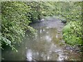
River Lugg, Whitton
by Richard Webb geograph for square SO2765 Tags:
top:Farm, Fishery, Market GardeningX
type:GeographX
river:River LuggX
top:Rivers, Streams, DrainageX
|
|
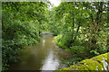
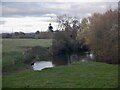
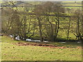
River Lugg
by Richard Webb geograph for square SO3965 Downstream from Lyepole Bridge.
|
|
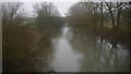
River Lugg near Leominster
by Richard Webb geograph for square SO5058 Upstream from Eaton Bridge
|
|
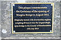
Wergins Bridge
by Chris Allen geograph for square SO5244 An early example of a reinforced concrete bridge and a rare example using the... (more)
|
|
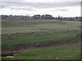
Lugg Meadows and flood defences opposite Mordiford
by Richard Webb geograph for square SO5637 Tags:
top:Farm, Fishery, Market GardeningX
type:GeographX
river:River LuggX
top:Rivers, Streams, DrainageX
|
|
Wergins Bridge - centenary plaque
by Chris Allen for square SO5244 |