Public Tags
Other tags: River Spey
Showing latest 50 of 85 images tagged with river:River Spey tag.
|
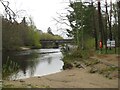
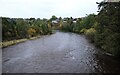
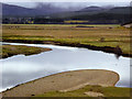
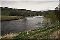
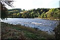
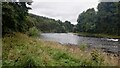
River Spey, Aviemore
by Malc McDonald geograph for square NH8911 A view of the River Spey flowing into Aviemore, in the Cairngorms National Park.... (more)
Tags:
place:AviemoreX
place:Cairngorms National ParkX
type:GeographX
subject:RiverX
river:River Spey
top:Rivers, Streams, DrainageX
country:ScotlandX
river:SpeyX
place:StrathspeyX
|
|
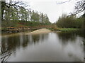
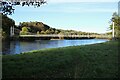
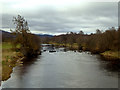
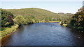
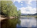
River Spey near Aviemore
by Malc McDonald geograph for square NH9012 A view of the River Spey near Aviemore, in the Highlands of Scotland. This area... (more)
Tags:
near:AviemoreX
place:CairngormsX
place:Cairngorms National ParkX
type:GeographX
subject:RiverX
river:River Spey
top:Rivers, Streams, DrainageX
country:ScotlandX
river:SpeyX
|
|
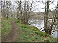
Path along the River Spey near Aviemore
by Malc McDonald geograph for square NH9012 A path alongside the River Spey near Aviemore, in the Highlands of Scotland.... (more)
|
|
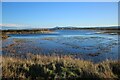
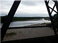
The River Spey at Spey Bay
by Richard Sutcliffe geograph for square NJ3465 The Spey Estuary is quite wide here and includes tidal lagoons just before... (more)
Tags:
top:CoastalX
top:Estuary, MarineX
type:GeographX
subject:RiverX
River SpeyX
top:Rivers, Streams, DrainageX
|
|
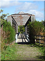
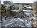
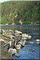
Balnellan Viaduct
by Anne Burgess geograph for square NJ1636 These days it's usually referred to as Ballindalloch Bridge, though... (more)
|
|
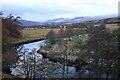
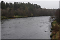
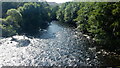
River Spey at Ruthven
by Richard Sutcliffe geograph for square NN7599 A bend in the River Spey, just upstream from Ruthven Bridge.
Tags:
type:GeographX
subject:RiverX
River SpeyX
top:Rivers, Streams, DrainageX
top:UplandsX
top:Woodland, ForestX
|
|
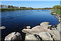
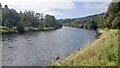
River Spey
by David Dixon geograph for square NJ0326 Looking upstream from Spey Bridge.
Tags:
type:GeographX
camera:Panasonic Lumix TZ60X
RiverX
river:River Spey
top:Rivers, Streams, DrainageX
Scottish HighlandsX
top:UplandsX
|
|
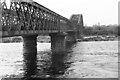
The Spey Viaduct
by Richard Sutcliffe geograph for square NJ3464 The viaduct over the River Spey was built for the Great North of Scotland... (more)
Tags:
type:GeographX
top:Historic Sites and ArtefactsX
railway:Moray Coast RailwayX
top:PathsX
top:RailwaysX
river:River Spey
top:Rivers, Streams, DrainageX
Scanned NegativeX
subject:ViaductX
|
|
River Spey
by Richard Sutcliffe geograph for square NJ2845 Seen from the Craigellachie Bridge.
Tags:
type:GeographX
top:Housing, DwellingsX
subject:RiverX
River SpeyX
top:Rivers, Streams, DrainageX
top:Woodland, ForestX
|
|
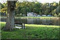
Boat House
by Richard Sutcliffe geograph for square NJ2642 Beside the River Spey.
Tags:
type:GeographX
subject:HouseX
top:Housing, DwellingsX
river:River Spey
top:Rivers, Streams, DrainageX
SeatX
top:Woodland, ForestX
|
|
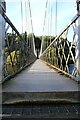
Victoria Bridge
by Richard Sutcliffe geograph for square NJ2642 Category A listed Link
Tags:
subject:BridgeX
type:GeographX
top:PathsX
river:River Spey
top:Rivers, Streams, DrainageX
Suspension Footbridge Over RiverX
top:Woodland, ForestX
|
|
Victoria Bridge
by Richard Sutcliffe geograph for square NJ2642 Category A listed Link
Tags:
subject:BridgeX
type:GeographX
top:PathsX
river:River Spey
top:Rivers, Streams, DrainageX
Suspension Footbridge Over RiverX
|
|
River Spey near Kingussie
by David Dixon geograph for square NH7600 Tags:
type:GeographX
camera:Panasonic Lumix TZ60X
RiverX
river:River Spey
top:Rivers, Streams, DrainageX
Scottish HighlandsX
|
|
River Spey, Upstream from Garten Bridge
by David Dixon geograph for square NH9419 Tags:
type:GeographX
camera:Panasonic Lumix TZ60X
river:River Spey
top:Rivers, Streams, DrainageX
Scottish HighlandsX
StrathspeyX
TreesX
|
|
River Spey, Downstream from Garten Bridge
by David Dixon geograph for square NH9419 Tags:
type:GeographX
camera:Panasonic Lumix TZ60X
river:River Spey
top:Rivers, Streams, DrainageX
Scottish HighlandsX
StrathspeyX
TreesX
|
|
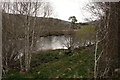
Brae Water on the River Spey
by Anne Burgess geograph for square NJ3356 Looking upstream from just north of the Earth Pillars.
|
|
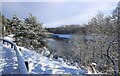
Old Bridge over the River Spey
by valenta geograph for square NJ0426 Ice on the bank of the River Spey on a bitter December day... (more)
Tags:
place:Cairngorms National ParkX
type:GeographX
river:River Spey
top:Rivers, Streams, DrainageX
subject:RiversideX
top:Roads, Road TransportX
top:UplandsX
|
|
River Spey
by Richard Sutcliffe for square NJ0326 Looking towards the New Spey Bridge. The bridge NJ0326 : New Spey Bridge was built in 1931... (more)
Tags:
top:Air, Sky, WeatherX
type:Cross GridX
subject:RiverX
River SpeyX
top:Rivers, Streams, DrainageX
SnowX
|
|
Brae Water
by Anne Burgess geograph for square NJ3357 Looking downstream from one of the groynes or jetties built to improve the... (more)
|
|
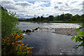
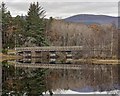
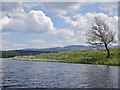
Boat of Insh Bridge
by valenta geograph for square NH8305 The category B listed Boat of Insh Bridge over the River Spey, where the north... (more)
Tags:
top:Boundary, BarrierX
subject:BridgeX
listed building:Category BX
type:GeographX
place:KincraigX
top:Lakes, Wetland, BogX
loch:Loch InshX
Parish BoundaryX
river:River Spey
top:Rivers, Streams, DrainageX
top:Roads, Road TransportX
top:UplandsX
top:Woodland, ForestX
|
|
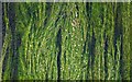
River weed in the Spey
by valenta for square NJ2642 A different view of the River Spey from the Victoria Bridge, looking down at the... (more)
Tags:
place:Charlestown of AberlourX
type:Close LookX
subject:RiverX
river:River Spey
top:Rivers, Streams, DrainageX
RiverweedX
top:UplandsX
top:Wild Animals, Plants and MushroomsX
|
|
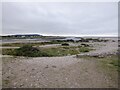
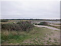
River Spey, Spey Bay
by Richard Webb geograph for square NJ3465 The Spey is unusual in being a large river without a usual estuary. It is... (more)
Tags:
BeachX
top:CoastalX
type:GeographX
top:Geological InterestX
river:River Spey
top:Rivers, Streams, DrainageX
Shingle BankX
|
|
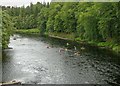
Kayaking on the River Spey
by valenta for square NJ0426 Viewed from the Old Spey Bridge
Tags:
type:Cross GridX
place:Grantown on SpeyX
KayakingX
subject:RiverX
river:River Spey
top:Rivers, Streams, DrainageX
top:Sport, LeisureX
top:UplandsX
|

|
Sunset Spey Bay Nature Reserve
by valenta geograph for square NJ3465 Looking over the mouth of the River Spey towards Garmouth at low tide
Tags:
top:Air, Sky, WeatherX
top:CoastalX
subject:EstuaryX
top:Estuary, MarineX
type:GeographX
Nature ReserveX
river:River Spey
top:Rivers, Streams, DrainageX
Spey BayX
top:Village, Rural SettlementX
|
|
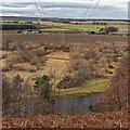
Pylon line over the River Spey
by valenta geograph for square NJ3356 The pylon line snakes its way over the fertile plain and up over the hillside to... (more)
Tags:
top:Energy InfrastructureX
top:Farm, Fishery, Market GardeningX
type:GeographX
top:LowlandsX
subject:PylonX
Pylon LinesX
river:River Spey
top:Rivers, Streams, DrainageX
place:Spey ValleyX
|
|
Shoring up the River Bank
by Anne Burgess geograph for square NJ3355 That's quite a robust bit of strengthening of the river bank, necessary to... (more)
|
|
View From the Speyside Way
by Peter Trimming geograph for square NJ0225 The Speyside Way utilises the former railway trackbed from Nethy Bridge up to... (more)
Tags:
top:Farm, Fishery, Market GardeningX
region:HighlandX
top:LowlandsX
subject:RiverX
River SpeyX
top:Rivers, Streams, DrainageX
country:ScotlandX
long distance footpath:Speyside WayX
|
|
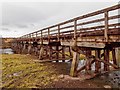
Broomhill Bridge over the River Spey
by valenta geograph for square NH9922 Category A listed wooden bridge over the River Spey
Tags:
subject:BridgeX
listed building:Category AX
type:GeographX
top:Historic Sites and ArtefactsX
river:River Spey
top:Rivers, Streams, DrainageX
top:Roads, Road TransportX
place:StrathspeyX
top:UplandsX
|
|
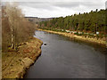
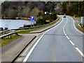
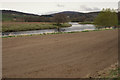
A95 Running Alongside the River Spey at Grantown-on-Spey
by David Dixon geograph for square NJ0326 Tags:
road:A95X
type:GeographX
camera:Panasonic Lumix TZ60X
Parking SignX
RiverX
river:River Spey
top:Rivers, Streams, DrainageX
top:Roads, Road TransportX
Scottish HighlandsX
TreesX
top:UplandsX
|
|
View From the Speyside Way
by Peter Trimming geograph for square NJ0225 The Speyside Way utilises the former railway trackbed from Nethy Bridge up to... (more)
Tags:
top:Farm, Fishery, Market GardeningX
region:HighlandX
top:LowlandsX
subject:RiverX
River SpeyX
top:Rivers, Streams, DrainageX
country:ScotlandX
long distance footpath:Speyside WayX
|
|
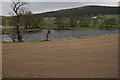
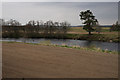
The upper Spey
by Richard Webb for square NN5494 View up the Spey from Am Maol. The new substation road can be seen right of the river.
Tags:
type:Cross GridX
top:MoorlandX
river:River Spey
top:Rivers, Streams, DrainageX
top:Roads, Road TransportX
top:Woodland, ForestX
|
|
River Spey, Spey Bay
by Richard Webb geograph for square NJ3465 |
|
River Spey From Spey Bridge.
by Peter Trimming geograph for square NJ0326 Not particularly inspiring, on what had become a wet day.
Tags:
top:Air, Sky, WeatherX
region:HighlandX
top:LowlandsX
subject:RiverX
River SpeyX
top:Rivers, Streams, DrainageX
country:ScotlandX
top:Woodland, ForestX
|
|
View From the Speyside Way
by Peter Trimming geograph for square NJ0224 The Speyside Way utilises the former railway trackbed from Nethy Bridge up to... (more)
Tags:
region:HighlandX
top:LowlandsX
subject:RiverX
River SpeyX
top:Rivers, Streams, DrainageX
country:ScotlandX
long distance footpath:Speyside WayX
|
|
River Spey, Insh Marshes
by Richard Webb geograph for square NH7901 The marshland is invisible from most of the river which has high banks. The... (more)
|
|
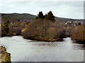
River Spey
by Richard Sutcliffe geograph for square NJ2643 Just north of Alice Littler Park, Aberlour.
Tags:
type:GeographX
subject:RiverX
river:River Spey
top:Rivers, Streams, DrainageX
top:Woodland, ForestX
|
|
River Spey
by Richard Webb geograph for square NJ1235 Downstream of Bridge of Advie.
|
|
River Spey
by Richard Webb for square NJ1135 Upstream of Bridge of Advie.
|
|
River Spey
by Richard Webb geograph for square NJ1536 Upstream of Cragganmore and quite fast flowing. There were a lot of fish... (more)
|
|
River Spey, Aikenway
by Richard Webb geograph for square NJ2950 |
|
River Spey, Garmouth
by Richard Webb geograph for square NJ3464 Near the outflow into the Moray Firth. The river is braided here and changes... (more)
Tags:
top:Derelict, DisusedX
railway:ELCX
type:GeographX
railway:Great North of Scotland RailwayX
railway:Moray Coast RailwayX
top:PathsX
top:RailwaysX
river:River Spey
top:Rivers, Streams, DrainageX
ViaductX
|
|
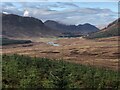
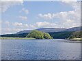
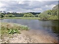
River Spey and Loch Insh
by Richard Webb geograph for square NH8203 Approaching the open loch.
|
|
River Spey approaching Loch Insh
by Richard Webb for square NH8203 |
|
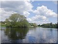
River Spey
by Richard Webb geograph for square NH8203 The alluvial plain at the head of Loch Insh.
|
|
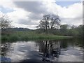
River Spey, Insh Marshes
by Richard Webb geograph for square NH8103 |
|
River Spey, Insh Marshes
by Richard Webb geograph for square NH8003 |
|
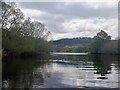
River Spey, Insh Marshes
by Richard Webb geograph for square NH8002 Very slow moving here.
|
|
River Spey, Insh
by Richard Webb geograph for square NH8002 A remote feel to the place with marshes beyond both banks.
|