Public Tags
Showing latest 50 of 240 images tagged with river:Tame tag.
|
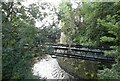
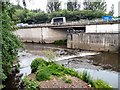
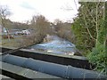
River Tame
by Gerald England geograph for square SJ8990 View downstream from the last footbridge over the River Tame. A bridge carrying... (more)
Tags:
type:GeographX
motorway:M60X
Pipe BridgeX
PipebridgeX
Pipeline BridgeX
top:Rivers, Streams, DrainageX
place:StockportX
river:Tame
|
|
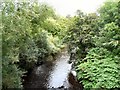
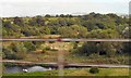
Here Goyt and Tame become Mersey
by Gerald England geograph for square SJ8990 The River Tame flows in from underneath the M60 motorway on the right and meets... (more)
Tags:
ConfluenceX
river:GoytX
motorway:M60X
river:MerseyX
MuralX
Public ArtworkX
top:Rivers, Streams, DrainageX
top:Roads, Road TransportX
river:Tame
|
|
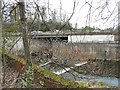
Pipe bridge over the River Tame
by Gerald England geograph for square SJ8990
The bridge carrying pipes over the River Tame appears to have been given a... (more)
Tags:
type:GeographX
motorway:M60X
PipebridgeX
Pipeline BridgeX
top:Rivers, Streams, DrainageX
place:StockportX
river:Tame
|
|
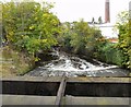
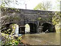
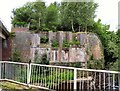
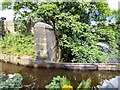
Junction Mill Chimney from Tame Aqueduct
by Gerald England geograph for square SJ9398
Looking at the River Tame downstream from the Tame Aqueduct towards Junction... (more)
|
|
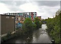
View from Bridge #28
by Gerald England geograph for square SJ9398 On the left is the Ashton Canal. The canalside apartments on the site of Samuel... (more)
Tags:
ApartmentsX
AqueductX
canal:Ashton CanalX
top:CanalsX
Canalside HousingX
type:GeographX
top:Housing, DwellingsX
top:Rivers, Streams, DrainageX
river:Tame
|
|
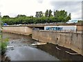
Goyt and Tame meet to form Mersey
by Gerald England geograph for square SJ8990 The Goyt (somewhat discoloured for some reason) flows over the weir and the... (more)
|
|
Overlooking the Confluence of the rivers Goyt & Tame
by Gerald England geograph for square SJ8990 The ironwork overlooking the confluence of the rivers Goyt and Tame to form the... (more)
Tags:
date:1994X
Commemorative IronworkX
ConfluenceX
river:GoytX
IronworkX
river:MerseyX
Public ArtworkX
top:Rivers, Streams, DrainageX
river:Tame
|
|
View from Bridge #28
by Gerald England geograph for square SJ9398 On the left is the Ashton Canal. The canalside apartments on the site of Samuel... (more)
Tags:
ApartmentsX
AqueductX
canal:Ashton CanalX
place:Ashton Under LyneX
top:CanalsX
Canalside HousingX
top:Housing, DwellingsX
canal:Peak ForestX
top:Rivers, Streams, DrainageX
river:Tame
|
|
Goyt and Tame become Mersey
by Gerald England geograph for square SJ8990 The Mersey starts here at the confluence of the Goyt (coming in from under... (more)
|
|
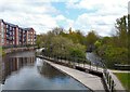
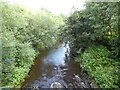
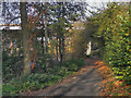
River Tame
by Gerald England geograph for square SJ8990 Looking upstream from the last footbridge over the River Tame.
Tags:
top:Rivers, Streams, DrainageX
river:Tame
|
|
The start of the river Mersey
by Gerald England geograph for square SJ8990 Viewed from the corner of Knightsbridge and Howard Street. The Goyt comes in... (more)
|
|
River Tame, Scout Green
by David Dixon geograph for square SD9701 The River Tame, just upstream (east) of the footbridge at Scout Green.
|
|
River Tame
by Gerald England geograph for square SJ8990
View upstream from the last footbridge over the River Tame.
|
|
Here beginneth the Mersey
by Gerald England geograph for square SJ8990
The River Tame flows in from underneath the M60 motorway on the right and... (more)
|
|
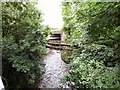
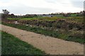
The last stretch of the River Tame
by Gerald England geograph for square SJ8990 After flowing under a footbridge the Tame flows under a pipe bridge and then... (more)
|
|
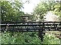
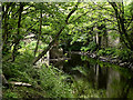
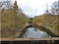
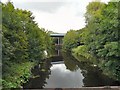
River Tame upstream from the canal aqueduct
by Gerald England geograph for square SJ9598 Upstream of the aqueduct carrying the Huddersfield Narrow Canal over the Tame... (more)
|
|
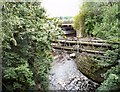
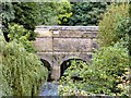
Aqueduct over the river Tame
by Gerald England geograph for square SJ9598 An aqueduct carries the Huddersfield Narrow Canal over the River Tame. As... (more)
|
|
Here, where the Mersey begins
by Gerald England geograph for square SJ8990 The River Tame flows in from underneath the M60 motorway and meets the River... (more)
Tags:
ConfluenceX
river:GoytX
motorway:M60X
river:MerseyX
MuralX
Public ArtworkX
top:Rivers, Streams, DrainageX
top:Roads, Road TransportX
river:Tame
|
|
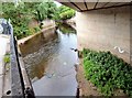
Geese in the river Tame
by Gerald England geograph for square SJ9395 A number of Canada geese in the River Tame. There were a whole lot more in the... (more)
|
|
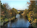
Tame Valley
by Gerald England geograph for square SJ9395 Looking across the River Tame towards Broomstair Farm. The M67 bridge is visible... (more)
|
|
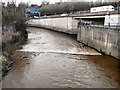
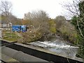
River Tame below Broomstair Bridge
by Gerald England geograph for square SJ9395 On the south side of Broomstair Bridge which carries the A57 over the River Tame... (more)
|
|
River Tame
by Gerald England geograph for square SJ8990 View downstream from the last footbridge over the River Tame. It is crossed by a... (more)
|
|
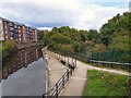
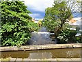
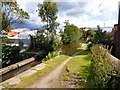
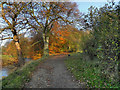
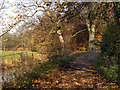
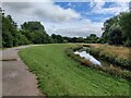
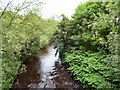
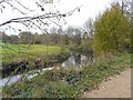
Riverside Path, River Tame
by David Dixon geograph for square SJ9395 Path along the eastern bank of the River Tame at Hyde.
Tags:
top:PathsX
RiverX
top:Rivers, Streams, DrainageX
Riverside PathX
top:Suburb, Urban FringeX
river:Tame
TreesX
|
|
Path Along The River Tame
by David Dixon geograph for square SJ9395 The riverside path on the eastern bank of the River Tame.
Tags:
top:PathsX
RiverX
top:Rivers, Streams, DrainageX
Riverside PathX
top:Suburb, Urban FringeX
river:Tame
|
|
Footpath by River Tame
by David Dixon geograph for square SJ9395 The footpath along the eastern bank of the River Tame at Hyde. The bridge... (more)
|
|
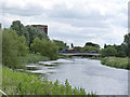
River Tame
by David Dixon geograph for square SJ9395 The M67 motorway crossing the River Tame at the boundary between Denton and Hyde.
|
|
Tame ending
by Gerald England geograph for square SJ8990 The end of the River Tame as it flows under the M60 motorway before joining the... (more)
|
|
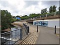
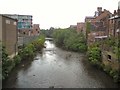
River Tame
by Gerald England geograph for square SJ9698 The River Tame from the Melbourne Street bridge looking towards Caroline Street.
|
|
Reddish Vale
by Gerald England geograph for square SJ9093 View over the River Tame from a train on the viaduct. In the distance are the... (more)
|
|
Path along the River Tame
by Mat Fascione geograph for square SP0392 Forge Mill Lake is to the left of the trees.
Forge Mill Lake is a local nature... (more)
|
|
River Tame, old course
by Alan Murray-Rust geograph for square SK1904 Looking towards Tame Drive bridge, carrying the southern ring road round... (more)
|
|
The end of the Tame
by Gerald England geograph for square SJ8990 At the end of its life the Tame passes under the M60 and joins the Goyt... (more)
Tags:
motorway:M60X
top:PathsX
top:Rivers, Streams, DrainageX
top:Roads, Road TransportX
river:Tame
long distance path:Trans Pennine TrailX
Transpennine TrailX
|
|
Aqueduct over the Tame
by Gerald England geograph for square SJ9398 The aqueduct carrying the Peak Forest Canal over the River Tame viewed from the... (more)
Tags:
AqueductX
place:Ashton Under LyneX
top:CanalsX
canal:Peak ForestX
top:Rivers, Streams, DrainageX
river:Tame
|
|
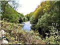
River Tame
by Gerald England geograph for square SJ9398 From the side of the towpath to the Ashton Canal.
Tags:
top:Rivers, Streams, DrainageX
river:Tame
|
|
River Tame
by Gerald England geograph for square SJ9395 Tags:
top:Rivers, Streams, DrainageX
river:Tame
|
|
River Tame
by Gerald England geograph for square SJ9395
Looking upstream from Broomstair Bridge towards the M67 motorway bridge.
Tags:
type:GeographX
motorway:M67X
Motorway BridgeX
top:Rivers, Streams, DrainageX
top:Roads, Road TransportX
river:Tame
|
|
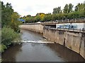
River Tame
by Gerald England geograph for square SJ9395
Looking downstream from Broomstair Bridge where it flows over a weir.
|
|
Dukinfield aqueduct
by Gerald England geograph for square SJ9398 The aqueduct carrying the Peak Forest Canal over the River Tame. A zoom shot... (more)
Tags:
AqueductX
top:CanalsX
type:GeographX
canal:Peak ForestX
top:Rivers, Streams, DrainageX
river:Tame
Willow TreeX
|
|
River Tame
by Gerald England geograph for square SJ9698
Looking downstream from Melbourne Street.
|
|
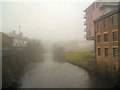
River Tame
by Gerald England geograph for square SJ9698 Looking upstream from the Caroline Street bridge on a misty day.
|
|
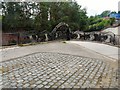
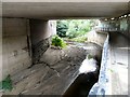
Former Bridge Abutments
by Gerald England geograph for square SJ8990 This was the point where the Cheshire Lines Committee (CLC) railway line through... (more)
Tags:
Cheshire Lines CommitteeX
type:GeographX
Old Bridge AbutmentsX
top:RailwaysX
top:Rivers, Streams, DrainageX
river:Tame
|
|
River Tame
by Gerald England geograph for square SJ8990 Upstream from the last footbridge over the river.
|
|
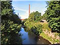
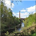
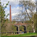
River, viaduct and chimney
by Gerald England geograph for square SJ9398 The nine-arch viaduct over the River Tame was built by the Sheffield,... (more)
|
|
River Tame
by Gerald England geograph for square SJ9398 Flowing through Dukinfield.
|
|
The side of the aqueduct
by Gerald England geograph for square SJ9598 Side of the aqueduct taking the Huddersfield Narrow Canal over the River Tame.
|
|
The very beginning of the River Mersey
by Gerald England geograph for square SJ8990 As the Tame emerges from underneath the M60 motorway it meets the Goyt... (more)
|
|
Viaduct and Chimney
by Gerald England geograph for square SJ9398 The viaduct carries the Leeds to Manchester railway over the River Tame. In the... (more)
|
|
Weir at Broomstair
by Gerald England geograph for square SJ9395 Weir on the River Tame from Broomstair Bridge.
|
|
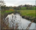
River Tame
by Gerald England geograph for square SJ9395 Near Dunkirk Farm.
|
|
River Tame
by Gerald England geograph for square SJ9395 Looking from Broomstair Bridge towards the M67 motorway bridge.
|