Geograph - photograph every grid square
About tags on Geograph
Tags
Geographical Context
Subjects
Types
Other Prefixes
Public Tags
Related Tags
|
Coverage Map
Tag:
Riverside·Rocks
Showing images tagged with
Riverside Rocks
tag.
View all tagged images
-
In Browser
Search within these images
:
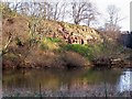
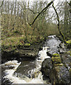
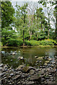
Sandstone Outcrop
by
David Chatterton
geograph for square
NT9350
A sandstone cliff face on the northern (Scottish) bank of the River Tweed, near... (
more
)
Tags:
top:
Lowlands
X
Outcropping Rocks
X
subject:
River Bank
X
River Tweed
X
top:
Rivers, Streams, Drainage
X
Riverside
X
Riverside Rocks
top:
Rocks, Scree, Cliffs
X
Sandstone Outcrop
X
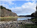
River Tees near Force Garth Quarry
by
Trevor Littlewood
geograph for square
NY8728
Apparently an idyllic wilderness scene but just around the bend in the river is... (
more
)
Tags:
type:
Geograph
X
Quarried Rock
X
top:
Quarrying, Mining
X
River
X
top:
Rivers, Streams, Drainage
X
Riverside Rocks
Rocks in River
X
top:
Rocks, Scree, Cliffs
X
top:
Uplands
X
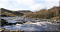
River Tees between High Force and Low Force
by
Trevor Littlewood
geograph for square
NY8928
A typical stretch of the upper river with rocks in and beside the water flow... (
more
)
Tags:
Cascades
X
type:
Geograph
X
top:
Lowlands
X
River
X
top:
Rivers, Streams, Drainage
X
Riverside Rocks
Rocks in River
X
top:
Rocks, Scree, Cliffs
X
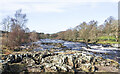
Rocks in and beside the River Tees
by
Trevor Littlewood
geograph for square
NY8728
The river looking upstream from just above High Force. Noon Hill is seen in the distance.
Tags:
type:
Geograph
X
top:
Lowlands
X
River
X
top:
Rivers, Streams, Drainage
X
Riverside Rocks
Rocks in River
X
top:
Rocks, Scree, Cliffs
X
top:
Uplands
X
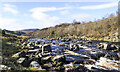
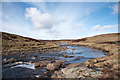
Rookhope Burn reaching rocky slot
by
Trevor Littlewood
geograph for square
NY9440
The stream here is below Ambling Gate Bank. Having tumbled over the distant... (
more
)
Tags:
Cascades
X
type:
Geograph
X
top:
Rivers, Streams, Drainage
X
Riverside Rocks
top:
Rocks, Scree, Cliffs
X
Stream
X
top:
Woodland, Forest
X
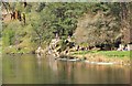
River Tweed near Hay Lodge park, Peebles
by
Jim Barton
for square
NT2340
A deep pool borders the rock outcrop, so it's a popular place on a hot day.
Tags:
type:
Cross Grid
X
top:
People, Events
X
top:
Rivers, Streams, Drainage
X
Riverside Rocks
top:
Rocks, Scree, Cliffs
X
river:
Tweed
X
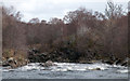
Disturbed water on River Carron
by
Trevor Littlewood
geograph for square
NH4992
The River Carron in Strathcarron east of Sgodachail looking downstream where its... (
more
)
Tags:
top:
Air, Sky, Weather
X
River
X
top:
Rivers, Streams, Drainage
X
Riverside Rocks
top:
Rocks, Scree, Cliffs
X
Wind Effect
X
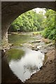
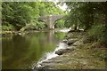
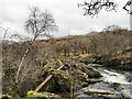
Beneath Austin's Bridge
by
Derek Harper
geograph for square
SX7565
The other end of the bridge from
SX7565 : Beneath Austin's Bridge
, seen from the same spot as
SX7565 : Austin's Bridge
.
Tags:
Bridge
X
river:
Dart
X
type:
Geograph
X
top:
Historic Sites and Artefacts
X
Listed Structure
X
top:
Lowlands
X
top:
Rivers, Streams, Drainage
X
Riverside Rocks
Riverside Trees
X
top:
Roads, Road Transport
X
Austin's Bridge
by
Derek Harper
for square
SX7565
"Said to be C16/C17"... (
more
)
Tags:
Bridge
X
type:
Cross Grid
X
river:
Dart
X
top:
Historic Sites and Artefacts
X
Listed Structure
X
top:
Lowlands
X
top:
Rivers, Streams, Drainage
X
Riverside Rocks
Riverside Trees
X
top:
Roads, Road Transport
X
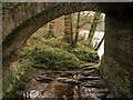
Beneath Austin's Bridge
by
Derek Harper
geograph for square
SX7565
Category: Arches
An arch on the northeastern side of the bridge over the River Dart.
Tags:
Bridge
X
river:
Dart
X
top:
Historic Sites and Artefacts
X
Listed Structure
X
top:
Rivers, Streams, Drainage
X
Riverside Rocks
Riverside Trees
X
top:
Roads, Road Transport
X
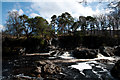
Cascade on River Carron
by
Trevor Littlewood
geograph for square
NH4891
The cascade on the River Carron just below the bridge where the roads on the... (
more
)
Tags:
Cascades
X
River
X
top:
Rivers, Streams, Drainage
X
Riverside Rocks
top:
Rocks, Scree, Cliffs
X
River Feshie flowing downstream towards Achleum
by
Trevor Littlewood
geograph for square
NN8596
A view to the north from a footbridge over the river. The small cottage,... (
more
)
Tags:
type:
Geograph
X
top:
Lowlands
X
Mountain Walker
X
River
X
top:
Rivers, Streams, Drainage
X
Riverside Rocks
top:
Rocks, Scree, Cliffs
X
top:
Sport, Leisure
X
top:
Uplands
X
Trees on north side of River Wear
by
Trevor Littlewood
geograph for square
NZ0936
As seen from the path on the south side of the river, also the route of the Weardale Way.
Tags:
Deciduous Trees
X
type:
Geograph
X
top:
Lowlands
X
River
X
top:
Rivers, Streams, Drainage
X
Riverside Rocks
top:
Rocks, Scree, Cliffs
X
top:
Woodland, Forest
X
The majestic River Dee...
by
Bill Harrison
geograph for square
NO6097
...viewed from beside Potarch Bridge.
Tags:
river:
Dee(Aberdeenshire)
X
type:
Geograph
X
top:
Rivers, Streams, Drainage
X
Riverside Rocks
top:
Rocks, Scree, Cliffs
X
top:
Uplands
X
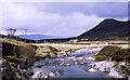
River Tees upstream
by
Trevor Littlewood
geograph for square
NY7731
The Tees is seen here in the vicinity of the location named on OS maps as... (
more
)
Tags:
type:
Geograph
X
Heather and Grass Moorland
X
top:
Moorland
X
River
X
subject:
River
X
top:
Rivers, Streams, Drainage
X
Riverside Rocks
top:
Rocks, Scree, Cliffs
X
top:
Uplands
X
River Lochay flowing past concrete barrier
by
Trevor Littlewood
geograph for square
NN5036
The river is flowing downstream along its main channel, but in the foreground,... (
more
)
Tags:
top:
Boundary, Barrier
X
Concrete Barriers
X
type:
Geograph
X
top:
Lowlands
X
River
X
top:
Rivers, Streams, Drainage
X
Riverside Rocks
View more in the Image Search
or
in Browser
View images matching 'Riverside Rocks' anywhere
in
the tags
Don't click these:
PotMel 1
PotMel 2
☰
Home
View
Search
Marked Images
Maps
Browser
Explore
Showcase
New Images
Collections
Interact
Games
Discussions
Blog
Contributors
Submit
Statistics
Leaderboards
General
FAQ
Help Pages
Sitemap
Contact Us
Support Us
sponsored by
🔍
What to search:
Photos
Enter keywords or a location/postcode to search nearby images
Enter a Grid Reference
Placenames
Collections
Website Pages
Everything
Others:
Advanced Search
|
Image Browser
Or:
Coverage Map
|
Searchable Map
You are not logged in
login
|
register