
|
Bridge and tunnel, Liversedge
by John Goldsmith
geograph for square SE2023
A bridge carries Halifax Road (so it says on the sign) over Sustrans Route 66.... (more)
|

|
South side of a road bridge over a former railway, Pontnewynydd
by Jaggery
geograph for square SO2701
The bridge carries the A4043 Osborne Road over a former railway
route which in... (more)
|
|
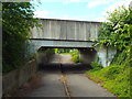
Bridge over path, near Laindon
by Malc McDonald
geograph for square TQ6688
This bridge carries the B1036 road over a footpath and cycle route on the edge... (more)
|

|
Bridge over Flitch Way, Felsted
by Roger Jones
geograph for square TL6921
As seen from the old Bannister Green Halt originally on the Great Eastern... (more)
|
|
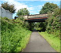
Road bridge over footpath near Sebastopol
by Jaggery
geograph for square ST2998
Avondale Road crosses over a footpath and cycleway, formerly a railway line.... (more)
|

|
Paths at Aviemore
by Malc McDonald
geograph for square NH8912
A junction of paths at Aviemore, in the Cairngorms National Park. The Aviemore... (more)
|
|
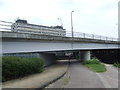
Under the North Circular, Edmonton
by Malc McDonald
geograph for square TQ3592
This bridge carries london's North Circular Road across the River Lee... (more)
|

|
A473 bridge over a footpath and cycle route, Angel Street, Bridgend
by Jaggery
geograph for square SS9079
Angel Street is on the right. The Ogmore River is below the wall on the left.
|

|
Under Pont Lesneven, Carmarthen
by Jaggery
geograph for square SN4019
The Wales Coast Path passes under Pont Lesneven... (more)
|

|
Footpaths in Arboretum with bridge under Addison Road
by Roger Templeman
geograph for square SK5640
|

|
Ford with a roof
by Neil Owen
for square ST7046
This path travels into a depression and is marked as a ford on the map, despite... (more)
|

|
Pipelines and a road bridge in Dare Valley Country Park
by Jaggery
geograph for square SN9902
Viewed from a track below the bridge carrying the main road through
the... (more)
|

|
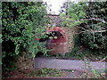
National Cycle Network route 67, Harrogate
by Malc McDonald
geograph for square SE3056
This path, shared by pedestrians and cyclists, forms part of National Cycle... (more)
|
|
South side of a former railway bridge, New Broughton
by Jaggery
geograph for square SJ3150
A combined cycleway and footpath on the former trackbed of a dismantled railway... (more)
|
|
Slip Road bridge, Milford Haven
by Jaggery
geograph for square SM9005
The combined footpath and cycleway passes under Slip Road.
|

|
Arch, Cockington
by Derek Harper
for square SX8963
The path from the Court to the lakes passes beneath Totnes Road, the lane from... (more)
|

|
Cycle route under the A31 near Ringwood
by Malc McDonald
geograph for square SU1906
A number of paths in the New Forest National Park can be used for cycling as... (more)
|

|
Rea Brook Walk, Shrewsbury
by Malc McDonald
geograph for square SJ5011
Here, Rea Brook Walk passes beneath the busy A458 road.
|
|
The A50 crossing the Cloud Trail
by Christine Johnstone
geograph for square SK3729
The Trail has been moved a few metres east of the original [higher] line of the... (more)
|
|
Path under road to Llanhilleth Colliery Memorial
by M J Roscoe
geograph for square SO2200
The path goes down from the derelict pithead baths under the High Street, B4471,... (more)
|

|
Footpath under the A44
by Philip Jeffrey
for square SP0938
|
|
Bridleway under the A44
by Philip Jeffrey
geograph for square SP1037
|

|
Lane to the Devil's Bridge, Kirkby Lonsdale
by Jim Barton
geograph for square SD6178
Looking from the end of Jingling Lane; the lane passes under Lunefield Drive.
|

|
Cycling on the old railway
by Neil Owen
geograph for square SU0993
The former Midland and South Western Junction line has been disused for decades... (more)
|

|
Former railway route under Station Road, Ferndale
by Jaggery
geograph for square ST0097
Now a footpath and cycle route, this used to be a railway, near the site of the... (more)
|
