Public Tags
Showing images tagged with road:A6211 tag.
|
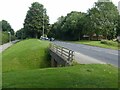
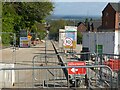
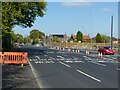
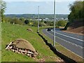
Subway under Arno Vale Road
by Alan Murray-Rust geograph for square SK5944 Part of the A6211 which forms a major orbital link round the north east of Nottingham.
Tags:
road:A6211
type:GeographX
Pedestrian SubwayX
top:Roads, Road TransportX
top:Suburb, Urban FringeX
Suburban Main RoadX
|
|
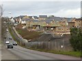
Chase Farm housing development
by Alan Murray-Rust geograph for square SK6143 Over 1000 homes are being provided in this redevelopment of the former Gedling... (more)
Tags:
road:A RoadX
road:A6211
top:Construction, DevelopmentX
type:GeographX
top:Housing, DwellingsX
New Housing DevelopmentX
top:Roads, Road TransportX
top:Suburb, Urban FringeX
|
|
Colliery Way alongside Gedling Country Park
by Alan Murray-Rust geograph for square SK6143 The landscaping of the road is now well settled.
|
|
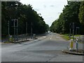
Junction of Plains Road and Arnold Lane
by Alan Murray-Rust geograph for square SK5944 The junction has been completely redesigned following the opening of Colliery... (more)
Tags:
road:A6211
type:GeographX
Road JunctionX
top:Roads, Road TransportX
top:Suburb, Urban FringeX
Suburban Main RoadX
|
|
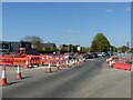
Arnold Lane, Mapperley
by Alan Murray-Rust geograph for square SK5944 Looking down from Plains Road. The road is closed pending the completion of the... (more)
Tags:
road:A6211
top:Construction, DevelopmentX
type:GeographX
Road ClosureX
top:Roads, Road TransportX
top:Suburb, Urban FringeX
Suburban Main RoadX
|
|
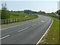
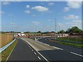
Colliery Way, Gedling
by Alan Murray-Rust geograph for square SK6342 The junction with Burton Road and Colwick Loop Road, now fully open.
|
|
Colliery Way, Gedling
by Alan Murray-Rust geograph for square SK6342 The new Gedling Access Road has acquired a name. This is the southern end... (more)
|
|
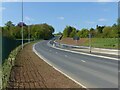
Arnold Lane, Gedling
by Alan Murray-Rust geograph for square SK6043 Currently the A 6211, a major suburban through route, shortly to be superseded... (more)
Tags:
road:A RoadX
road:A6211
type:GeographX
top:Roads, Road TransportX
top:Suburb, Urban FringeX
Suburban Main RoadX
|
|
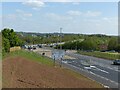
Junction of Colliery Way with Mapperley Plains
by Alan Murray-Rust geograph for square SK6044 As yet not fully complete following the opening of Colliery Way.
Tags:
road:A6211
BypassX
type:GeographX
Road JunctionX
top:Roads, Road TransportX
top:Suburb, Urban FringeX
Suburban Main RoadX
|
|
Upper roundabout on Colliery Way, Chase Farm development
by Alan Murray-Rust geograph for square SK6043 In due course this will be connected to Arnold Lane, the links being currently... (more)
Tags:
road:A6211
BypassX
top:Construction, DevelopmentX
type:GeographX
Road ConstructionX
top:Roads, Road TransportX
RoundaboutX
|
|
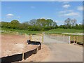
Access to Gedling Wood Farm
by Alan Murray-Rust geograph for square SK6243 Prior to the construction of Colliery Way, access to the farm was via a lane... (more)
Tags:
road:A6211
BypassX
Farm Access RoadX
top:Farm, Fishery, Market GardeningX
type:GeographX
top:Roads, Road TransportX
|
|
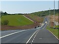
Colliery Way, Gedling
by Alan Murray-Rust geograph for square SK6243 Looking north towards the junction with Lambley Lane. This is the opposite... (more)
|
|
Colliery Way, Gedling
by Alan Murray-Rust for square SK6242 The climb up from Burton Road. The mounds on the side of the cutting have been... (more)
Tags:
road:A6211
BypassX
type:Cross GridX
top:Roads, Road TransportX
top:Wild Animals, Plants and MushroomsX
Wildlife HabitatX
|
|
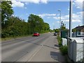
Arno Vale Road, Arnold
by Alan Murray-Rust geograph for square SK5944 Recreating this 'First' for the square Link
Tags:
road:A6211
type:GeographX
Revisited FirstX
top:Roads, Road TransportX
top:Suburb, Urban FringeX
Suburban Main RoadX
|
|
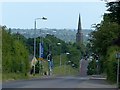
Arnold Lane, Gedling
by Alan Murray-Rust for square SK6143 Showing the hilly nature of this part of Gedling, looking towards the Trent... (more)
Tags:
road:A RoadX
road:A6211
Church SpireX
type:Cross GridX
top:Religious SitesX
top:Roads, Road TransportX
top:Suburb, Urban FringeX
Suburban Main RoadX
|
|
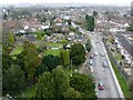
Arnold Lane, Gedling
by Alan Murray-Rust geograph for square SK6142 Looking south from the tower of All Hallows Church an unexpected bonus on a... (more)
Tags:
road:A RoadX
road:A6211
type:GeographX
High Level ViewX
top:Roads, Road TransportX
top:Suburb, Urban FringeX
Suburban Main RoadX
SuburbiaX
|
|
Arnold Lane, Gedling
by Alan Murray-Rust geograph for square SK6142 Looking north west from the tower of All Hallows Church an unexpected bonus on... (more)
Tags:
road:A RoadX
road:A6211
type:GeographX
High Level ViewX
top:Housing, DwellingsX
top:Roads, Road TransportX
top:Suburb, Urban FringeX
Suburban Main RoadX
SuburbiaX
|
|
Chase Farm, Gedling
by Alan Murray-Rust geograph for square SK6143 One year on from Link the houses are... (more)
Tags:
road:A RoadX
road:A6211
type:GeographX
Housing EstateX
top:Housing, DwellingsX
top:Roads, Road TransportX
top:Suburb, Urban FringeX
|
|
A new view across the Trent Valley
by Alan Murray-Rust geograph for square SK6044 Made possible as a result of the construction of Colliery Way. The spire of All... (more)
Tags:
road:A6211
BypassX
type:GeographX
top:LowlandsX
top:Roads, Road TransportX
place:Trent ValleyX
View Across ValleyX
|
|
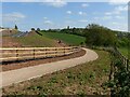
Colliery Way, Gedling
by Alan Murray-Rust geograph for square SK6044 Looking down the upper section towards the Chase Farm development which will... (more)
Tags:
road:A6211
BypassX
top:Construction, DevelopmentX
type:GeographX
New Housing DevelopmentX
top:Roads, Road TransportX
RoundaboutX
place:Trent ValleyX
View Across ValleyX
|
|
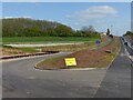
Footpath to Gedling
by Alan Murray-Rust geograph for square SK6243 The completed path following opening of Colliery Way, looking in the opposite... (more)
|
|
Footpath to Spring Lane
by Alan Murray-Rust geograph for square SK6243 Realigned as a result of the construction of Colliery Way. Compare with... (more)
|