Geograph - photograph every grid square
About tags on Geograph
Tags
Geographical Context
Subjects
Types
Other Prefixes
Public Tags
Related Tags
|
Coverage Map
Prefix:
road
Tag:
B5381
Showing images tagged with
road:
B5381
tag.
View all tagged images
-
In Browser
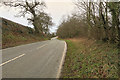
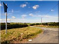
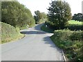
Ffordd Rhufeinig (Roman Road) B5381
by
David Dixon
geograph for square
SH9873
The B5381 runs for 18 miles from Llandudno Junction to Trefnant near St Asaph... (
more
)
Tags:
road:
B5381
Country Lane
X
type:
Geograph
X
camera:
IPhone SE
X
top:
Roads, Road Transport
X
Roman Road
X
Rural Road
X
Ffordd Rhufeinig (Roman Road) near Bodelwyddan
by
David Dixon
geograph for square
SH9973
The B5381 runs for 18 miles from Llandudno Junction to Trefnant near St Asaph... (
more
)
Tags:
road:
B5381
Country Lane
X
type:
Geograph
X
camera:
IPhone SE
X
top:
Roads, Road Transport
X
Roman Road
X
Rural Road
X
The B5381 near Coed Cae Moch
by
Christine Johnstone
geograph for square
SH9774
Looking westwards at the 146 metre spot height. A parish boundary runs down the... (
more
)
Tags:
road:
B Road
X
road:
B5381
boundary:
Civil Parish
X
type:
Geograph
X
subject:
Road
X
top:
Roads, Road Transport
X
Route of Roman Road
X
B5381 heading west
by
Christine Johnstone
geograph for square
SH9873
The route of a Roman road, between Bryn y Pin and Bryn y Pin Mawr.
Tags:
road:
B Road
X
road:
B5381
type:
Geograph
X
subject:
Road
X
top:
Roads, Road Transport
X
Route of Roman Road
X
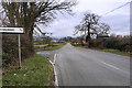
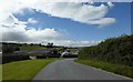
Junction near Glasfryn
by
Gerald England
geograph for square
SH8375
The junction of the B5381 and the B5113.
Tags:
B Road (Classified B)
X
road:
B5113
X
road:
B5381
Junction of B Classified Roads
X
top:
Roads, Road Transport
X
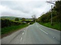
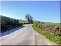
The B5381 Ffridd y Mynydd
by
Steve Fareham
geograph for square
SH8275
Tags:
road:
B5381
top:
Roads, Road Transport
X
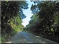
Tree on the B5381 at Glascoed
by
Christine Johnstone
geograph for square
SH9973
Looking east towards the hamlet.
Tags:
road:
B5381
Deciduous Tree
X
type:
Geograph
X
top:
Roads, Road Transport
X
Roadside Tree
X
subject:
Tree
X
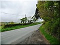
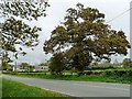
B5381 near Peniarth Bach
by
David Dixon
geograph for square
SH9273
Tags:
road:
B5381
Hedge
X
camera:
Iphone 4s
X
top:
Roads, Road Transport
X
top:
Uplands
X
top:
Village, Rural Settlement
X
Crossroads on the B5138
by
Gerald England
geograph for square
SH8175
Tags:
road:
B5381
Crossroads
X
type:
Geograph
X
top:
Roads, Road Transport
X
Farm at Peniarthy Bach
by
Steve Fareham
geograph for square
SH9273
Tags:
road:
B5381
top:
Farm, Fishery, Market Gardening
X
top:
Roads, Road Transport
X
View more in the Image Search
or
in Browser
View images matching 'B5381' anywhere
in
the tags
Don't click these:
PotMel 1
PotMel 2
☰
Home
View
Search
Marked Images
Maps
Browser
Explore
Showcase
New Images
Collections
Interact
Games
Discussions
Blog
Contributors
Submit
Statistics
Leaderboards
General
FAQ
Help Pages
Sitemap
Contact Us
Support Us
sponsored by
🔍
What to search:
Photos
Enter keywords or a location/postcode to search nearby images
Enter a Grid Reference
Placenames
Collections
Website Pages
Everything
Others:
Advanced Search
|
Image Browser
Or:
Coverage Map
|
Searchable Map
You are not logged in
login
|
register