Public Tags
Other tags: Station Road
approaching:Station Road
in:Station Road
looking towards:Station Road
name:Station Road
near:Station Road
off:Station Road
on:Station Road
place:Station Road
taken from:Station Road
to:Station Road
Showing latest 50 of 362 images tagged with road:Station Road tag.
|
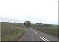
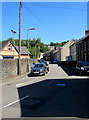
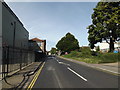
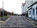
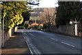
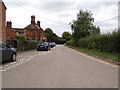
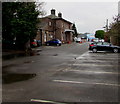
Station Road, Old Newton
by Geographer geograph for square TM0462 Near Station Road Level Crossing & the former Haughley Railway Station
|
|
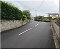
Western end of Station Road, Letterston
by Jaggery geograph for square SM9429 Looking east along Station Road across the A40. The name is a reminder of the... (more)
|
|
Fork in Station Road, Ruabon
by Jaggery geograph for square SJ3043 Vehicles for Ruabon railway station must turn left here. The northern half of... (more)
|
|
Mini-roundabout at the southern end of Station Road, Chirk
by Jaggery geograph for square SJ2837 At the junction of Station Road and the B4500 Castle Road.
A sign on the right... (more)
|
|
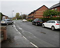
Station Road, Bakewell
by Jaggery geograph for square SK2268 Station Road climbs away from the centre of Bakewell towards the Monsal Trail... (more)
|
|
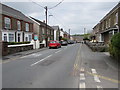
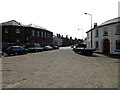
Station Road houses, Ponthir, Torfaen
by Jaggery geograph for square ST3292 Left along Station Road for the B4236 Caerleon Road. Beyond the right edge of... (more)
Tags:
type:GeographX
top:Housing, DwellingsX
top:Roads, Road TransportX
road:Station Road
Station RoadX
top:Village, Rural SettlementX
|
|
Down Station Road, Abergavenny
by Jaggery geograph for square SO3013 Viewed on a rainy, misty day in December 2023. Station Road descends towards the... (more)
|
|
Station Road, Ponthir, Torfaen
by Jaggery geograph for square ST3292 Viewed across the B4236 Caerleon Road in May 2020. The sign on the right shows... (more)
Tags:
type:GeographX
top:Roads, Road TransportX
Station RoadX
road:Station Road
top:Village, Rural SettlementX
|
|
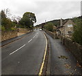
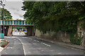
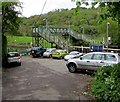
Bridges over Station Road
by Ian Capper geograph for square TQ1656 Railway bridges over Station Road, by the exit from Mole Business Park, south of... (more)
|
|
Sunshine and shadows, Station Road, Risca
by Jaggery geograph for square ST2390 Viewed on June 22nd 2018. Station Road leads to the site of the old Risca... (more)
|
|
Up Station Road, Trealaw
by Jaggery geograph for square ST0092 Part of the ascent of Station Road from Dinas Rhondda railway station to... (more)
Tags:
type:GeographX
top:Roads, Road TransportX
road:Station Road
Station RoadX
top:Village, Rural SettlementX
|
|
Station Road, Creigiau
by Jaggery geograph for square ST0881 Viewed across Cardiff Road. Creigiau Inn... (more)
Tags:
type:GeographX
top:Roads, Road TransportX
road:Station Road
Station RoadX
top:Village, Rural SettlementX
|
|
Up Station Road, Govilon
by Jaggery geograph for square SO2613 Station Road ascends from the B4246 Merthyr Road, viewed in July 2017.
The... (more)
|
|
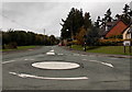
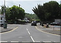
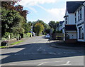
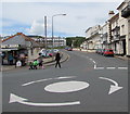
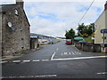
Junction of Station Road and The Esplanade, Sidmouth
by Jaggery geograph for square SY1287 The mini-roundabout on The Esplanade is at the southern end of the B3176 Station... (more)
Tags:
road:B3176X
type:GeographX
Mini-RoundaboutX
Road JunctionX
top:Roads, Road TransportX
road:Station Road
|
|
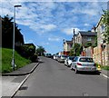
Station Road, Llangynwyd
by Jaggery geograph for square SS8688 Station Road descends from the corner of the A4063 Bridgend Road.
This was... (more)
Tags:
type:GeographX
top:Roads, Road TransportX
Station RoadX
road:Station Road
top:Village, Rural SettlementX
|
|
B1077 Station Road & Station Road George VI Postbox
by Geographer geograph for square TM0595 Postbox No.NR17 1734D
Tags:
at:AttleboroughX
B Road (Classified B)X
B1077X
B1077 Station RoadX
top:Business, Retail, ServicesX
top:City, Town CentreX
type:GeographX
postbox:George VIX
postbox:GRX
PostboxX
Postbox No.NR17 1734DX
subject:RoadX
top:Roads, Road TransportX
Station RoadX
Station Road George VI PostboxX
Station Road PostboxX
|
|
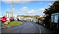
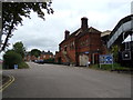
B1077 Station Road, Attleborough
by Geographer geograph for square TM0594 Approaching Station Road Level Crossing
|
|
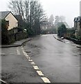
Down Station Road, Stockport
by Jaggery geograph for square SJ8989 Station Road descends towards the western entrance... (more)
|
|
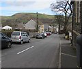
Station Road, Ystradgynlais
by Jaggery geograph for square SN7810 Looking along Station Road towards the town centre in May 2016, more than eighty... (more)
|
|
Down Station Road, Johnston
by Jaggery geograph for square SM9310 Viewed from the corner of the A4076 St Peter's Road. Station Road descends... (more)
|
|
Northern end of Station Road, Abercynon
by Jaggery geograph for square ST0894 Viewed across the B4275. The entrance to Abercynon railway station is nearly 300... (more)
|
|
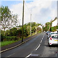
Station Road towards Caersws railway station
by Jaggery geograph for square SO0291 Turn left ahead at the Trefeglwys Road junction for Caersws railway station.... (more)
Tags:
top:Housing, DwellingsX
top:Roads, Road TransportX
road:Station Road
Station RoadX
top:Village, Rural SettlementX
|
|
Station Road, Cardigan
by Jaggery geograph for square SN1745 Viewed across Castle Street.
Station Road formerly led to Cardigan railway... (more)
|
|
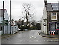
Station Road, Templecombe
by Jaggery geograph for square ST7022 Station Road ascends from High Street towards the entrance... (more)
|
|
Station Road reaches its destination in Freshford
by Jaggery geograph for square ST7960 Nearly 300 metres from its southern end at The Hill, Station Road reaches... (more)
|
|
Station Road towards Abergavenny railway station
by Jaggery geograph for square SO3013 From the corner of the A40 Monmouth Road. The station... (more)
|
|
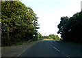
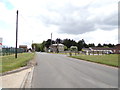
B1085 Station Road approaching bridge over the A14
by Geographer geograph for square TL7067 Near Kennett Railway Station
Tags:
A14X
B Road (Classified B)X
B1085X
B1085 Station RoadX
at:KennettX
near:Kennett Railway StationX
Railway StationX
subject:RoadX
top:Roads, Road TransportX
Station RoadX
over:The A14X
|
|
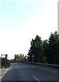
B1085 Station Road, Kennett
by Geographer geograph for square TL7067 Near Kennett Railway Station
|
|
Looking towards the A145 Station Road
by Geographer geograph for square TM4290 At Beccles Railway Station
Tags:
A145X
A145 Station RoadX
at:BecclesX
at:Beccles Railway StationX
top:City, Town CentreX
Railway StationX
top:RailwaysX
subject:RoadX
top:Roads, Road TransportX
Station RoadX
|
|
Station Road & Station Road Railway Bridge
by Geographer geograph for square TM4495 Looking towards Church Lane near the former Railway Station
Road No.C388
Tags:
at:AldebyX
subject:BridgeX
C Classified RoadX
C Road (Classified C)X
looking towards:Church LaneX
Former Railway StationX
Railway BridgeX
subject:RoadX
top:Roads, Road TransportX
Station RoadX
Station Road Railway BridgeX
|
|
SE along Station Road, Portskewett, Monmouthshire
by Jaggery geograph for square ST5088 Station Road formerly led to Portskewett railway station where passenger... (more)
|
|
White arrow on Station Road, Llanwern
by Jaggery geograph for square ST3688 Faded in February 2023, the arrow is at the start of two-way traffic
beyond... (more)
Tags:
type:GeographX
top:Roads, Road TransportX
road:Station Road
Station RoadX
top:Village, Rural SettlementX
|
|
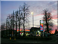
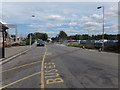
Esso Fuel Station, Station Road, Ashby-de-la-Zouch
by Oliver Mills geograph for square SK3516 The fuel station is partially screened during the day by a very attractive... (more)
Tags:
place:AshbyX
Ashby De La ZouchX
top:Business, Retail, ServicesX
top:City, Town CentreX
Fuel Filling StationX
subject:Fuel PumpX
type:GeographX
tree:LimeX
top:Roads, Road TransportX
road:Station Road
|
|
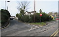
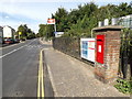
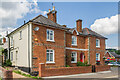
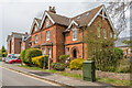
1 & 3 Station Road
by Ian Capper geograph for square TQ1649 Pair of semi-detached houses in Station Road, marked on the 1870 1:500 town plan.
Tags:
building:1 Station RoadX
building:3 Station RoadX
place:DorkingX
type:GeographX
top:Housing, DwellingsX
road:Station Road
top:Suburb, Urban FringeX
|
|
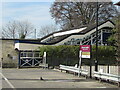
Entrance to Stroud railway station
by Jaggery geograph for square SO8405 From Station Road in Stroud town centre.
The station footbridge is in the background.
Tags:
top:City, Town CentreX
type:GeographX
top:RailwaysX
top:Roads, Road TransportX
road:Station Road
Station RoadX
|
|
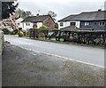
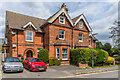
2 - 4 Station Road
by Ian Capper geograph for square TQ2953 Semi-detached late Victorian houses on Station Road.
Tags:
building:2 Station RoadX
building:4 Station RoadX
type:GeographX
top:Housing, DwellingsX
place:MersthamX
road:Station Road
top:Suburb, Urban FringeX
|
|
2 - 4 Station Road
by Ian Capper geograph for square TQ2953 Semi-detached late Victorian houses on Station Road. Beyond is Pullman Place, a... (more)
Tags:
building:2 Station RoadX
building:4 Station RoadX
type:GeographX
top:Housing, DwellingsX
place:MersthamX
building:Pullman PlaceX
road:Station Road
top:Suburb, Urban FringeX
|
|
Station Road, Attlebridge & former level crossing
by Geographer geograph for square TG1217 Near former Attlebridge Railway Station
Road No.C260
Tags:
at:AttlebridgeX
near:Attlebridge Railway StationX
C Road (Classified C)X
type:GeographX
former:Level CrossingX
subject:RoadX
top:Roads, Road TransportX
Station RoadX
top:Village, Rural SettlementX
|
|
B1112 Station Road, Brandon
by Geographer geograph for square TL7286 Approaching Lakenheath Railway Station
Tags:
B Road (Classified B)X
B1112X
B1112 Station RoadX
at:BrandonX
type:GeographX
near:Hockwold Cum WiltonX
approaching:Lakenheath Railway StationX
subject:RoadX
top:Roads, Road TransportX
Station RoadX
top:Village, Rural SettlementX
|

|
Bargoed railway station footbridge
by Jaggery geograph for square SO1500 Viewed across the A469 Station Road in June 2019. Originally, access to the... (more)
Tags:
type:GeographX
Railway Station FootbridgeX
top:RailwaysX
top:Roads, Road TransportX
road:Station Road
|

|
West along Station Road, Llanbradach
by Jaggery geograph for square ST1490 From High Street along Station Road towards Llanbradach railway station.
Tags:
type:GeographX
top:Roads, Road TransportX
Station RoadX
road:Station Road
top:Village, Rural SettlementX
|
|
Station Road, Wakes Colne
by Geographer geograph for square TL8928 At Chappel & Wakes Colne Railway Station
Tags:
at:Chappel & Wakes Colne Railway StationX
type:GeographX
subject:RoadX
top:Roads, Road TransportX
Station RoadX
top:Village, Rural SettlementX
at:Wakes ColneX
|
|
Station Road, Wakes Colne
by Geographer geograph for square TL8928 At Chappel & Wakes Colne Railway Station
Tags:
at:Chappel & Wakes Colne Railway StationX
type:GeographX
subject:RoadX
top:Roads, Road TransportX
Station RoadX
top:Village, Rural SettlementX
at:Wakes ColneX
|
|
Station Road at Chappel & Wakes Colne Railway Station
by Geographer geograph for square TL8928 Tags:
at:Chappel & Wakes Colne Railway StationX
type:GeographX
subject:RoadX
top:Roads, Road TransportX
Station RoadX
top:Village, Rural SettlementX
at:Wakes ColneX
|
|
Station Road, Cattawade
by Geographer geograph for square TM0932 Near Manningtree Railway Station
Tags:
type:GeographX
at:LawfordX
near:ManningtreeX
near:Manningtree Railway StationX
Railway StationX
subject:RoadX
top:Roads, Road TransportX
Station RoadX
top:Suburb, Urban FringeX
|

|
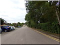
West along Station Road, Hawarden
by Jaggery geograph for square SJ3165 From the corner of the B5125 The Highway along Station Road towards Hawarden... (more)
Tags:
type:GeographX
top:Housing, DwellingsX
top:Roads, Road TransportX
Station RoadX
road:Station Road
|
|
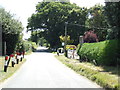
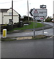
Station Road direction signs, Pentlepoir
by Jaggery geograph for square SN1106 The signs facing the A478 show that the B4316 leads to Saundersfoot railway... (more)
Tags:
road:B4316X
Direction SignsX
type:GeographX
top:Roads, Road TransportX
Station RoadX
road:Station Road
top:Village, Rural SettlementX
|
|
Northern end of Station Road, Abergavenny
by Jaggery geograph for square SO3013 Looking south towards the main station buildings.... (more)
Tags:
type:GeographX
Railway Station BuildingsX
top:RailwaysX
top:Roads, Road TransportX
road:Station Road
Station RoadX
|
|
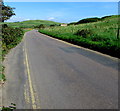
Rural part of Station Road beyond West Bay, Dorset
by Jaggery geograph for square SY4690 Looking east along Station Road in the direction of the B3157 Burton Road.... (more)
|
|
Station Road towards Kemble railway station
by Jaggery geograph for square ST9897 West along Station Road from Windmill Road. The station is out of shot about 350... (more)
|