Public Tags
Tag: Sheep·Fank
Other tags: ruin:Sheep Fank
Showing images tagged with Sheep Fank tag.
|
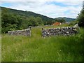
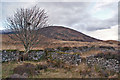
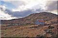
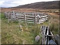
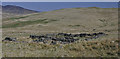
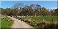
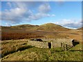
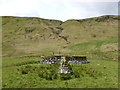
Old sheep fank
by Lairich Rig geograph for square NN3003 As the end-note says, this sheep fank is located just a few metres to the north... (more)
|
|
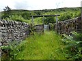
Old sheep fank: interior
by Lairich Rig geograph for square NN3003 See NN3003 : Old sheep fank for a view from outside, and click on the end-note title for... (more)
|
|
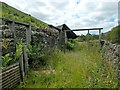
Old sheep fank: interior
by Lairich Rig geograph for square NN3003 See NN3003 : Old sheep fank for a view from outside; click on the end-note title for other... (more)
|
|
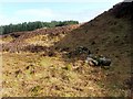
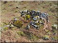
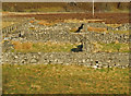
Remains of a structure
by Lairich Rig geograph for square NS4580 Category: Sheep fanks According to the "Concise Scots Dictionary" (Chambers) a "sheep... (more)
|
|
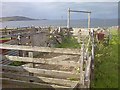
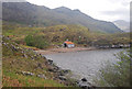
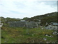
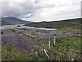
Sheep fank at Kylerhea
by Richard Dorrell geograph for square NG7819 Looking north west from inside the disused sheep fank above the shore at Kylerhea.
Tags:
top:Derelict, DisusedX
top:Farm, Fishery, Market GardeningX
place:Isle of SkyeX
place:KylerheaX
Sheep Fank
|
|
Sheep fank at Kylerhea
by Richard Dorrell geograph for square NG7819 This large sheep fank above the shore at Kylerhea has been disused for many... (more)
Tags:
top:Derelict, DisusedX
top:Farm, Fishery, Market GardeningX
place:Isle of SkyeX
place:KylerheaX
Sheep Fank
|
|
Sheep Fanks, Sand
by Mick Garratt geograph for square NG9191 |
|
Sheep fank, Kylerhea
by Richard Dorrell geograph for square NG7819 The stone built fank has been disused for many years, though was substantially... (more)
Tags:
top:CoastalX
top:Derelict, DisusedX
top:Farm, Fishery, Market GardeningX
place:Isle of SkyeX
place:KylerheaX
Sheep Fank
|
|
Hut and sheep fank, Kylerhea
by Richard Dorrell geograph for square NG7820 Both have been disused for many years. The stone built fank is extensive and... (more)
Tags:
top:Derelict, DisusedX
top:Farm, Fishery, Market GardeningX
place:Isle of SkyeX
place:KylerheaX
Sheep Fank
|
|
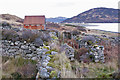
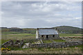
Sheep Fank and Shed
by Glen Breaden geograph for square NM7891 This former collection point for sheep would be for transportation by boat.
Tags:
top:Farm, Fishery, Market GardeningX
Sheep Fank
|
|
Remains of a structure
by Lairich Rig for square NS4580 Category: Sheep fanks See NS4580 : Remains of a structure for the main description.
This is a view along the long axis... (more)
|
|
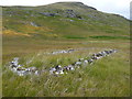
Sheep Pens by Creag Bheag
by valenta geograph for square NH7702 Coils of rusty fencing wire by the old sheep fank
Tags:
place:Cairngorms National ParkX
top:Derelict, DisusedX
top:Farm, Fishery, Market GardeningX
type:GeographX
top:MoorlandX
Sheep Fank
subject:SheepfoldX
top:UplandsX
|
|
Sheep fank at Slaggan
by Richard Dorrell geograph for square NG8494 The settlement of Slaggan is ruined and deserted by humans, but sheep still... (more)
|
|
Remains of a structure (detail)
by Lairich Rig for square NS4580 Category: Sheep fanks See NS4580 : Remains of a structure for the main description of the ree as a whole.
The present... (more)
|
|
Sheep fank by Loch Phlocrapoil
by Dave Fergusson geograph for square NG1693 Tags:
top:Farm, Fishery, Market GardeningX
Sheep Fank
|
|
Sheep fank by Loch a' Mhonaidh
by Dave Fergusson geograph for square NG1695 Tags:
top:Farm, Fishery, Market GardeningX
Sheep Fank
|
|
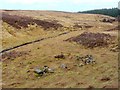
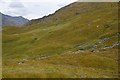
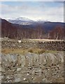
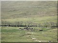
Sheep fank below Am Beannan
by Iain A Robertson geograph for square NN6914 Long disused, the walls have tumbled.
Tags:
top:Derelict, DisusedX
Sheep Fank
|
|
Sheep fank
by Patrick Mackie for square NH0217 Beside the Affric-Kintail footpath.
|
|
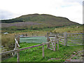
Sheepfold by the A855
by Richard Dorrell geograph for square NG4948 Marked on the OS map as a sheepfold, but more commonly known as a fank in these... (more)
Tags:
top:Farm, Fishery, Market GardeningX
place:Isle of SkyeX
place:Loch FadaX
subject:PenX
Sheep Fank
|
|
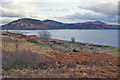
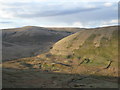
Sheep fank below Beinn a' Bhric
by Richard Dorrell geograph for square NH3564 Part of the forest in the background has been felled fairly recently. The summit... (more)
|
|
Sheep fanks in Glen Truim
by John Allan geograph for square NN6791 |
|
Sheep fank
by Lairich Rig geograph for square NS3281 The structure is located at the edge of Quarry Wood, beside the point where a... (more)
|
|
Well built drystone walled sheep fank
by Russel Wills geograph for square NN9750 With Ben Vrackie in the distance.
|
|
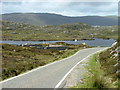
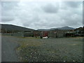
New sheep fank
by Dave Fergusson geograph for square NG0687 By the Fionnsabagh (Finsbay) to An t-Ob (leverburgh) road.
|
|
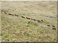
Nineteen red deer
by Patrick Mackie geograph for square NR7970 Nineteen red deer, including a young stag, which moved off up the glen as I... (more)
|
|
Sheep stell near Stobo Hopehead
by Alan O'Dowd geograph for square NT1339 Brown Dod and Flint Hill in the background.
|
|
Sheep Dip, Laonairidh, Colonsay
by Tom Richardson geograph for square NR3995 |
|
Old sheepfold on Doddin
by Alan O'Dowd geograph for square NS9312 A view across the Peden Burn as evening light catches the hillside of Doddin.
|
|
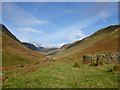
Black Hope
by Alan O'Dowd geograph for square NT1410 Black Hope is the name of the valley, through which the Blackhope Burn (a... (more)
|
|
Sheepfold near Castles Farm
by Patrick Mackie geograph for square NN1329 A view from the hydro road running up towards Beinn a Chochuill.
|
|
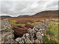
Ruined longhouse (or a sheepfank) at the base of Carn a' Choire Bhuidhe
by Richard Law geograph for square NH1815 |
|
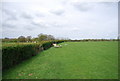
High Weald Landscape Trail follows a hedge
by N Chadwick geograph for square TQ8331 |
|
Old sheepfold below Ewe Hill
by Alan O'Dowd geograph for square NS6600 The steep hillside is split here by the Small Cleugh which tumbles down through... (more)
Tags:
top:GrasslandX
subject:HistoricalX
top:MoorlandX
top:Rivers, Streams, DrainageX
Sheep Fank
SheepfoldX
Southern UplandsX
top:UplandsX
|