Geograph - photograph every grid square
About tags on Geograph
Tags
Geographical Context
Subjects
Types
Other Prefixes
Public Tags
Related Tags
|
Coverage Map
Tag:
Shore·Road
Other tags:
road:
Shore Road
Showing images tagged with
Shore Road
tag.
View all tagged images
-
In Browser
Search within these images
:
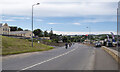
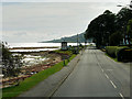
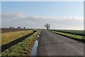
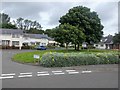
The Shore Road, Killybegs
by
Rossographer
geograph for square
G7176
The Shore Road at Killybegs, it snakes along the large harbour.
Tags:
top:
Coastal
X
type:
Geograph
X
place:
Killybegs
X
Killybegs
X
subject:
Road
X
Road
X
top:
Roads, Road Transport
X
road:
Shore Road
X
Shore Road
The Shore Road, Magheramorne
by
Rossographer
geograph for square
J4298
The A2 Shore Road at Magheramorne.
Tags:
road:
A2
X
top:
Coastal
X
type:
Geograph
X
Housing
X
subject:
Road
X
Road
X
Roads
X
top:
Roads, Road Transport
X
Shore Road
top:
Village, Rural Settlement
X
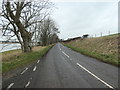
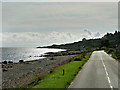
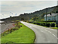
B725 at an 8 metre spot height
by
Christine Johnstone
geograph for square
NX9968
Shore Road heading north to Glencaple along the shore of the Nith estuary.
Tags:
road:
B Road
X
road:
B725
X
type:
Geograph
X
subject:
Road
X
top:
Roads, Road Transport
X
road:
Shore Road
X
Spot Height
X
Concrete Mixer on the Shore Road
by
Des Blenkinsopp
geograph for square
TQ8913
A concrete mixer truck leaves a building site at the end of the road.
Tags:
top:
Coastal
X
type:
Geograph
X
top:
Roads, Road Transport
X
Shore Road
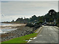
Shore Road and Beach at Whiting Bay
by
David Dixon
geograph for square
NS0425
Whiting Bay (Scottish Gaelic: Eadar Dhà Rubha) is the third-largest village on... (
more
)
Tags:
road:
A841
X
Beach
X
Coast Road
X
top:
Coastal
X
Firth of Clyde
X
type:
Geograph
X
Isle of Arran
X
camera:
Panasonic DMC-G7
X
top:
Roads, Road Transport
X
Shore Road
top:
Village, Rural Settlement
X
Whiting Bay, Shore Road
by
David Dixon
geograph for square
NS0426
Whiting Bay (Scottish Gaelic: Eadar Dhà Rubha) is the third-largest village on... (
more
)
Tags:
road:
A841
X
Coast Road
X
type:
Geograph
X
Isle of Arran
X
camera:
Panasonic DMC-G7
X
top:
Roads, Road Transport
X
Shore Road
top:
Village, Rural Settlement
X
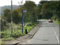
Bus Stop on Shore Road at Whiting Bay
by
David Dixon
geograph for square
NS0426
Tags:
road:
A841
X
Bus Stop
X
Coast Road
X
type:
Geograph
X
Isle of Arran
X
camera:
Panasonic DMC-G7
X
top:
Roads, Road Transport
X
Shore Road
top:
Village, Rural Settlement
X
Shore Road, Whiting Bay
by
David Dixon
geograph for square
NS0426
Whiting Bay (Scottish Gaelic: Eadar Dhà Rubha) is the third-largest village on... (
more
)
Tags:
20 Mph Speed Limit Sign
X
road:
A841
X
Coast Road
X
top:
Coastal
X
Firth of Clyde
X
type:
Geograph
X
Isle of Arran
X
camera:
Panasonic DMC-G7
X
top:
Roads, Road Transport
X
Shore Road
top:
Village, Rural Settlement
X
Shore (Shorey) Road, facing east
by
J.Hannan-Briggs
geograph for square
TF3843
Tags:
top:
Flat Landscapes
X
top:
Roads, Road Transport
X
road:
Shore Road
X
Beach and Shore Road at Largymore
by
David Dixon
geograph for square
NS0424
Tags:
road:
A841
X
Beach
X
Coast Road
X
top:
Coastal
X
Firth of Clyde
X
type:
Geograph
X
Isle of Arran
X
camera:
Panasonic DMC-G7
X
Shore Road
A waterfront residence by Shore Road
by
Stanley Howe
geograph for square
NO3329
Near access to Kings Mason at Kingoodie.
Tags:
Cottage
X
subject:
Cottage
X
postcode area:
DD2
X
type:
Geograph
X
top:
Housing, Dwellings
X
top:
Roads, Road Transport
X
road:
Shore Road
X
Street Junction
X
top:
Village, Rural Settlement
X
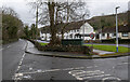
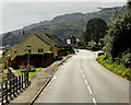
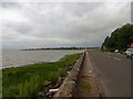
Shore Road at Kingoodie
by
Stanley Howe
geograph for square
NO3329
Heading west towards Errol, with River Tay and sea wall on left.
Tags:
top:
Coastal
X
postcode area:
DD2
X
top:
Estuary, Marine
X
type:
Geograph
X
Kingoodie Bay
X
RiverTay
X
subject:
Road
X
top:
Roads, Road Transport
X
Sea Wall
X
road:
Shore Road
X
top:
Village, Rural Settlement
X
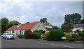
Kings Mason, Kingoodie
by
Stanley Howe
geograph for square
NO3329
Access to housing estate from Shore Road.
Tags:
postcode area:
DD2
X
place:
Dundee
X
type:
Geograph
X
Houses
X
subject:
Housing Estate
X
top:
Housing, Dwellings
X
top:
Roads, Road Transport
X
road:
Shore Road
X
Street Sign
X
top:
Suburb, Urban Fringe
X
Tree
X
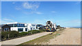
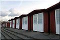
Beach huts along Shore Road, Swanage
by
Phil Champion
geograph for square
SZ0379
Tags:
Beach Huts
X
top:
Coastal
X
place:
Isle of Purbeck
X
Seaside
X
Shore Road
top:
Sport, Leisure
X
place:
Swanage
X
A841 at Largymore
by
David Dixon
geograph for square
NS0424
Whiting Bay (Scottish Gaelic: Eadar Dhà Rubha) is the third-largest village on... (
more
)
Tags:
road:
A841
X
Coast Road
X
top:
Coastal
X
type:
Geograph
X
Isle of Arran
X
camera:
Panasonic DMC-G7
X
top:
Roads, Road Transport
X
Shore Road
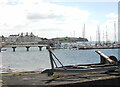
View south to The Saltpans and Portaferry Marina
by
Rod Grealish
geograph for square
J5950
The Saltpans is a residential development. The pier is in the middle distance... (
more
)
Tags:
district:
Ards and North Down Borough
X
postcode district:
BT22
X
top:
City, Town Centre
X
top:
Coastal
X
county:
County Down
X
top:
Docks, Harbours
X
type:
Geograph
X
top:
Housing, Dwellings
X
subject:
Loch
X
irish:
Port an Pheire
X
place:
Portaferry
X
subject:
Portaferry Marina
X
road:
Shore Road
X
top:
Sport, Leisure
X
Strangford Lough
X
subject:
The Saltpans
X
View more in the Image Search
or
in Browser
View images matching 'Shore Road' anywhere
in
the tags
Don't click these:
PotMel 1
PotMel 2
☰
Home
View
Search
Marked Images
Maps
Browser
Explore
Showcase
New Images
Collections
Interact
Games
Discussions
Blog
Contributors
Submit
Statistics
Leaderboards
General
FAQ
Help Pages
Sitemap
Contact Us
Support Us
sponsored by
🔍
What to search:
Photos
Enter keywords or a location/postcode to search nearby images
Enter a Grid Reference
Placenames
Collections
Website Pages
Everything
Others:
Advanced Search
|
Image Browser
Or:
Coverage Map
|
Searchable Map
You are not logged in
login
|
register