|
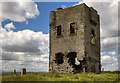
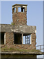
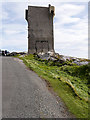
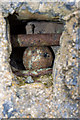
Rathlee Signal Tower, Co. Sligo (1)
by Mike Searle
geograph for square G3237
In response to the 1798 Irish Rebellion and the threat of invasion from the... (more)
|
|
Old Signal Tower, Slieve League
by Rossographer
for square G5674
The old signal tower at Carrigan Head, Slieve League.... (more)
|
|
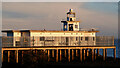
Old Lighthouse And Signal Tower
by Mick Garratt
geograph for square NT2677
"On end of W breakwater: c. 1950. Supported by reinforced concrete... (more)
|
|
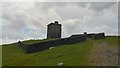
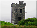
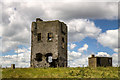
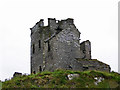
Bray Head Tower, Valentia Island, County Kerry
by Phil Champion
geograph for square V3373
A derelict signal tower built in 1815 during the Napoleonic wars. The two storey... (more)
|
|
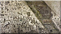
Graffiti inside Bray Head Tower, Valentia Island, County Kerry
by Phil Champion
for square V3373
A derelict signal tower built in 1815 during the Napoleonic wars. The two storey... (more)
|
|
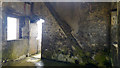
Interior of Bray Head Tower, Valentia Island, County Kerry
by Phil Champion
for square V3373
A derelict signal tower built in 1815 during the Napoleonic wars. The two storey... (more)
|
|
Bray Head Tower, Valentia Island, County Kerry
by Phil Champion
geograph for square V3373
A derelict signal tower built in 1815 during the Napoleonic wars. The two storey... (more)
|
|
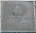
Hynish Signal Tower plaque
by M J Richardson
for square NL9839
Above the door on the east side of the tower. It reads :-
Commissioners of... (more)
|
|
Signal tower
by Neil Owen
for square ST7570
The old control tower at Charmy Down was operational from 1941 to the 1950s, but... (more)
|
|
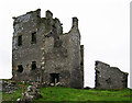
Spain Tower, Baltimore, Cork (1)
by Garry Dickinson
geograph for square W0525
A C19 Napoleonic era signal tower stands tall on a remote headland to the... (more)
|
|
Dromnea Signal Tower, Kilcrohane, Cork
by Garry Dickinson
geograph for square V8438
Built in c.1805 it was one of an extensive network of signal towers which were... (more)
|
|
Signal Tower
by Ian Paterson
geograph for square NO6440
View of the prominent landmark and museum in the morning sun.
|
|
Waiting room and signal tower, Kilcreggan Pier
by Christine Johnstone
geograph for square NS2480
Kilcreggan Pier is the oldest surviving wooden pier on the Clyde. The black and... (more)
|
|
Hynish Signal Tower 1843
by M J Richardson
geograph for square NL9839
Used to signal, by semaphore, to and from the Skerryvore construction site while... (more)
|
|
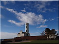
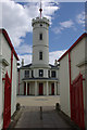
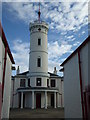
Signal Tower Museum, Arbroath
by Stephen McKay
geograph for square NO6440
The Signal Tower was built in 1813 as the shore station for the Bell Rock... (more)
|

|
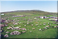
Signal Tower on Crohy Head, Crohy Townland
by Mac McCarron
for square B7008
Category: Tower
Named as Crohy Tower on OS Ireland maps.
|
|
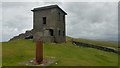
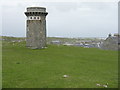
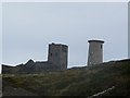
Pike Hill signal tower
by Sandy Gerrard
geograph for square NY5764
Built 30 years before Hadrian's Wall it was later incorporated into the... (more)
|
|
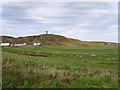
Malin Head Signal Tower
by David Dixon
geograph for square C3959
A military watchtower was built at Banba's Crown in 1805, during the... (more)
|
|
Signalling Tower
by Billy McCrorie
geograph for square NX4836
Path up to Tower.
|
|
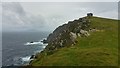
Tower on Isle Head
by Andy Farrington
geograph for square NX4835
View from the rocky cliffs on Isle Head inland to the Signalling Tower on the Isle.
|
|
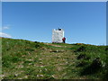
Rathlee Signal Tower, Co. Sligo (3)
by Mike Searle
geograph for square G3237
In view to the left of the tower is the hilltop trig pillar, and on the right a... (more)
|
|
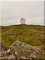
Rathlee Signal Tower, Co. Sligo (2)
by Mike Searle
for square G3237
As if the erroneous "castle" description on the plaque on the wall was... (more)
|
|
Rocky Ground at Hynish
by Des Blenkinsopp
geograph for square NL9839
Showing the signal tower which was used for communicating with the Skerryvore... (more)
|
|
Ballyhillin, View Towards the Signal Tower on Malin Head
by David Dixon
geograph for square C4059
The view towards Malin Head from Ballyhillin. Sheep grazing in the field to the right.
|
|
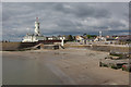
Arbroath seafront
by Stephen McKay
geograph for square NO6440
|
|
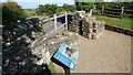
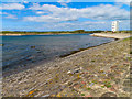
Old Lighthouse and Signal Tower, Cape Clear Island
by Becky Williamson
geograph for square V9621
|
|
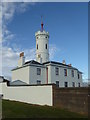
Signal tower for Bell Rock Lighthouse
by Chris Allen
for square NO6440
Built 1812 by Robert Stevenson to communicate with the lighthouse 12 miles off... (more)
|
|
Signal Tower for Bell Rock Lighthouse
by Chris Allen
geograph for square NO6440
Built in 1812 by Robert Stevenson to communicate with the lighthouse 12 miles... (more)
|
|
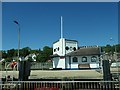
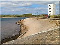
Breakwater by the River Irvine
by Steve Daniels
geograph for square NS3037
The Pilot House was built for Martin Boyd's Automatic Tide Signalling... (more)
|
|
The Pilot House and breakwater at Irvine
by Steve Daniels
geograph for square NS3037
The Pilot House was built for Martin Boyd's Automatic Tide Signalling... (more)
|
|
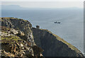
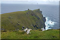
Cliffs on the north side of Bray Head, below Bray Head Tower
by Phil Champion
for square V3373
|
|
Spain Tower, Baltimore, Cork (2)
by Garry Dickinson
geograph for square W0525
|
|
Cliffs on the north side of Bray Head, Valentia Island
by Phil Champion
geograph for square V3373
The islands on the horizon are Skellig Michael and Little Skellig.
|