Public Tags
Tag: Smart·Motorway
Showing images tagged with Smart Motorway tag.
|
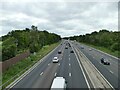
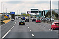
The upgraded M6 - not such a smart idea
by Stephen Craven geograph for square SJ7371 The M6 through Cheshire is currently operated as a 'smart' motorway... (more)
|
|
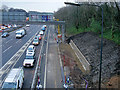
Smartening the M60
by David Dixon geograph for square SD8104 Ongoing roadworks to convert the M60 into a "smart" motorway... (more)
Tags:
top:Construction, DevelopmentX
Exit SliproadX
type:GeographX
motorway:M60X
Manchester Outer Ring RoadX
MORRX
MotorwayX
camera:Panasonic DMC-G7X
Road WorksX
top:Roads, Road TransportX
Slip RoadX
Smart Motorway
top:Suburb, Urban FringeX
|
|
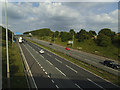
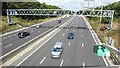
M62 east of Field Head Lane
by Stephen Craven geograph for square SE2227 This section of the motorway is now a 'smart' one with former hard... (more)
|
|
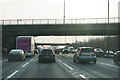
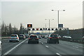
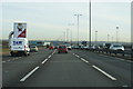
The M6 at Junction 10
by Bill Boaden geograph for square SO9998 The smart motorway is keeping traffic moving steadily even if not very fast.
Tags:
type:GeographX
top:LowlandsX
Motorway JunctionX
top:Roads, Road TransportX
Smart Motorway
top:Suburb, Urban FringeX
|
|
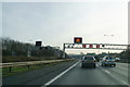
Smart motorway in operation
by Bill Boaden geograph for square SJ9603 The M54 is just joining the M6 from the left. It is inappropriate to be using... (more)
|
|
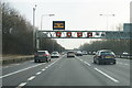
Smart motorway in operation
by Bill Boaden geograph for square SJ9801 Why is only one of the red circles working? The one mile sign for Junction 10... (more)
Tags:
GantryX
type:GeographX
top:LowlandsX
top:Roads, Road TransportX
Smart Motorway
top:Suburb, Urban FringeX
TrafficX
|
|
Smart motorway in operation
by Bill Boaden geograph for square SJ9703 Now the M54 lanes have finally merged into the M6, the hard shoulder can be used.
|
|
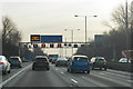
Smart motorway in operation
by Bill Boaden geograph for square SJ9800 There is heavy traffic on the M6 approaching Junction 10.
Tags:
type:GeographX
top:LowlandsX
top:Roads, Road TransportX
Smart Motorway
top:Suburb, Urban FringeX
|
|
Northbound M6 at Bescot
by David Dixon geograph for square SP0196 Between junctions 8 and 9 of the M6 near Walsall.
Tags:
Emergency Refuge AreaX
type:GeographX
motorway:M6X
MotorwayX
camera:Panasonic DMC-G7X
top:Roads, Road TransportX
Smart Motorway
|
|
The M1
by David Lally geograph for square SK3697 Just south of junction 35a, looking north up the southbound carriageway.
Tags:
type:GeographX
road:M1X
subject:MotorwayX
Motorway Sign GantryX
top:Roads, Road TransportX
Smart Motorway
|
|
The M6 at Bescot
by Bill Boaden geograph for square SP0096 The floodlights to the right indicate the Bescot railway sidings.
Tags:
type:GeographX
top:LowlandsX
top:Roads, Road TransportX
Smart Motorway
top:Suburb, Urban FringeX
|