Public Tags
Tag: Stone·Bridge·Over·River
Showing latest 50 of 109 images tagged with Stone Bridge Over River tag.
|
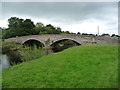
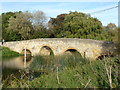
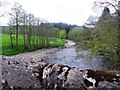
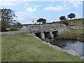
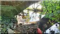
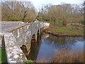
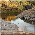
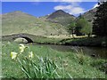
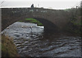
Musgrave Bridge, from the east
by Christine Johnstone geograph for square NY7613 Carrying the B6295 over the River Eden. Once there was a ford [or wath] here,... (more)
|
|
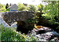
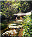
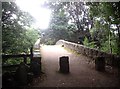
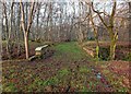
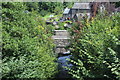
Stone footbridge over River Duddon
by Andy Deacon geograph for square SD2296 Beautiful narrow bridge over the river Duddon near High Wallowbarrow.
Tags:
county:CumbriaX
river:DuddonX
bridge:FootbridgeX
Footbridge Across RiverX
bridge:Footbridge Over RiverX
top:PathsX
river:River DuddonX
top:Rivers, Streams, DrainageX
Stone BridgeX
Stone Bridge Over River
StoneworkX
|
|
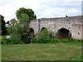
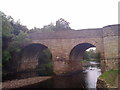
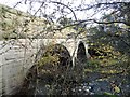
Stone bridge over the River Trothy, Mitchel Troy
by Jaggery geograph for square SO5011 The bridge carries a side road over the River Trothy.... (more)
|
|
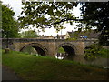
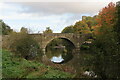
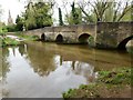
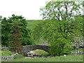
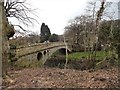
Crawford Bridge
by Nigel Mykura geograph for square ST9102 This shows the structure of this ancient stone bridge on the upstream side of... (more)
|
|
Grade II listed stone bridge in Felindre, Powys
by Jaggery geograph for square SO1723 The Grade II listed two-arch rubble stone road bridge dates from c1700.
It... (more)
|

|
Stone bridge over Rhiangoll, Cwmdu, Powys
by Jaggery geograph for square SO1824 The bridge carries a minor road over Rhiangoll, a tributary of the River Usk.
|
|
Bridge at Bidford
by Nigel Mykura geograph for square SP0951 This is an eight arched bridge which probably dated originally from the 13th... (more)
|
|
Swarkestone Bridge
by Steve Fareham geograph for square SK3628 The bridge, an ancient monument, is just under a mile in length over the River... (more)
|
|
Pack horse bridge over the River Welland, Deeping St. James
by Paul Bryan geograph for square TF1509 The pack horse bridge, which is located on Deeping St. James Road at the... (more)
|
|
Old stone bridge in Fotheringhay
by Richard Humphrey geograph for square TL0692 |
|
Bridge over River Churnet
by Jonathan Hutchins geograph for square SJ9949 This is at the confluence of the River Churnet and to the left the Caldon Canal.
Tags:
subject:BridgeX
Bridge Over a RiverX
canal:Caldon CanalX
Canal and River JunctionX
top:CanalsX
type:GeographX
River BridgeX
river:River ChurnetX
top:Rivers, Streams, DrainageX
Stone Bridge Over River
|
|
Dinham Bridge over River Teme from riverside walk
by Martin Dawes geograph for square SO5074 Tags:
type:GeographX
top:Historic Sites and ArtefactsX
top:LowlandsX
castle:LudlowX
top:PathsX
river:River TemeX
top:Rivers, Streams, DrainageX
top:Roads, Road TransportX
Stone Bridge Over River
Stone Road BridgeX
top:Suburb, Urban FringeX
|
|
The River Ise in Geddington
by Richard Humphrey geograph for square SP8982 A view through one of the arches of the ancient stone bridge from a car stopped... (more)
Tags:
BridgeX
FordX
type:GeographX
subject:RiverX
RiverX
top:Rivers, Streams, DrainageX
Stone BridgeX
Stone Bridge Over River
|
|
Upstream River Braan
by Stanley Howe geograph for square NN9740 From over the stone parapet of Newton Bridge.
Tags:
river:BraanX
place:DunkeldX
postcode area:PH8X
subject:RiverX
top:Rivers, Streams, DrainageX
top:Roads, Road TransportX
Stone Bridge Over River
Stone ParapetX
|
|
Polyphant Bridge over River Inny
by David Smith geograph for square SX2682 The area around the bridge, Hicks Mill, is a conservation area, described in... (more)
|
|
Bridge over the River Derwent at Blanchland
by Robert Graham geograph for square NY9650 This two arch stone bridge dates from 1841. The river here forms the border... (more)
|
|
Bridge taking track over River Skirfare 1km west of Litton
by Roger Templeman geograph for square SD8974 There is an Ordnance Survey benchmark SD8974 : Benchmark on back of west parapet of bridge taking track over River Skirfare on the bridge wall on the left... (more)
Tags:
Dry River BedX
type:GeographX
Ordnance SurveyX
river:River SkirfareX
top:Rivers, Streams, DrainageX
Stone Bridge Over River
bridge:Track Over RiverX
|
|
Bridge over Walla Brook near Riddon Brake
by Vieve Forward geograph for square SX6677 The small wooden sign at the left side the bridge reads: "This is an... (more)
Tags:
BrookX
DartmoorX
type:GeographX
subject:MoorlandX
top:MoorlandX
top:Rivers, Streams, DrainageX
Stone BridgeX
Stone Bridge Over River
|
|
Old and New Drygrange Bridges over River Tweed
by Martin Dawes geograph for square NT5734 Built 1778-80 and 1971-3 respectively to carry the A68 over the River Tweed
Tags:
road:A68X
type:GeographX
top:LowlandsX
Metal Bridge Over RiverX
top:Rivers, Streams, DrainageX
top:Roads, Road TransportX
place:Scottish BordersX
Stone Bridge Over River
river:TweedX
top:Woodland, ForestX
|
|
Bridge Over The Windrush
by Des Blenkinsopp geograph for square SP1620 Looking like a scene in some ornamental garden from this angle, this elegant... (more)
|
|
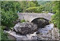
Ale Water bridge at Riddell
by Jim Barton geograph for square NT5124 A handsome single arched stone bridge in the Riddell estate.
|
|
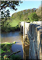
River Petteril at Relton's Bridge
by Roger Templeman for square NY4352 There is an Ordnance Survey NY4352 : Benchmark on Relton's Bridge on the stone in the bridge wall left of... (more)
Tags:
type:Close LookX
Ordnance SurveyX
river:PetterilX
top:Rivers, Streams, DrainageX
Stone Bridge Over River
|
|
Bridge, ford and river in Geddington
by Richard Humphrey geograph for square SP8982 Tags:
BridgeX
FordX
type:GeographX
RiverX
subject:RiverX
top:Rivers, Streams, DrainageX
Stone BridgeX
Stone Bridge Over River
|
|
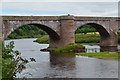
Ladykirk and Norham Bridge over the Tweed (3)
by Jim Barton for square NT8947 The central spans of this four-span bridge that dates from 1887. The figure... (more)
|
|
Ladykirk and Norham Bridge over the Tweed
by Jim Barton geograph for square NT8847 The English - Scottish border follows the Tweed hereabouts and crosses the... (more)
|
|
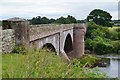
Boldre Bridge
by Mike Smith geograph for square SZ3198 This is a Grade II listed structure. It dates from the late 18th century and is... (more)
|
|
Bridge of Tanar
by Stanley Howe geograph for square NO4896 An old stone bridge over the Water of Tanar, now restricted by granite blocks... (more)
Tags:
place:AboyneX
top:Country EstatesX
Glen Tanar EstateX
top:Rivers, Streams, DrainageX
Stone Bridge Over River
|
|
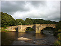
The bridge at Beckermonds
by Christine Johnstone geograph for square SD8780 Carrying the narrow road to Green Field over the River Wharfe.
Tags:
Bridges in North YorkshireX
place:LangstrothdaleX
top:Rivers, Streams, DrainageX
bridge:Road Over RiverX
Stone Bridge Over River
river:WharfeX
|
|
Marton Bridge over River Seven
by Martin Dawes geograph for square SE7383 |
|
Stone bridge over the Udale Burn
by valenta geograph for square NH7164 The old road that is marked on the 1872 25" OS map shows this bridge over... (more)
Tags:
subject:BridgeX
type:GeographX
top:LowlandsX
top:PathsX
Stone Bridge Over River
The Black IsleX
burn:Udale BurnX
top:Woodland, ForestX
|
|
Drygrange Old Bridge no longer takes traffic
by Martin Dawes geograph for square NT5734 Built 1778-80. The new Drygrange Bridge built 1971-3 to carry the A68 is beyond... (more)
Tags:
road:A68X
FootpathX
type:GeographX
top:LowlandsX
Metal Bridge Over RiverX
top:PathsX
top:Rivers, Streams, DrainageX
top:Roads, Road TransportX
place:Scottish BordersX
Stone Bridge Over River
river:TweedX
|
|
Bridge Over the River Manifold
by Jonathan Clitheroe geograph for square SK1059 T-junction and stone bridge pictured here from the entrance to the Manifold Inn.
|
|
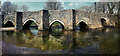
Lostwithiel Bridge
by Andy Stephenson geograph for square SX1059 A mostly 15th Century stone road bridge, connecting Lostwithiel village with its... (more)
Tags:
subject:BridgeX
county:CornwallX
area:CornwallX
place:CornwallX
type:GeographX
place:LostwithielX
top:Rivers, Streams, DrainageX
top:Roads, Road TransportX
Stone Arch Bridges in EnglandX
Stone Bridge Over River
|
|
Burn of Boyne
by valenta geograph for square NJ6166 The Burn of Boyne forms a pool here just before it flows into the sea. the stone... (more)
Tags:
place:Boyne BayX
river:Burn of BoyneX
top:CoastalX
top:Estuary, MarineX
type:GeographX
top:Quarrying, MiningX
top:Rivers, Streams, DrainageX
Stone Bridge Over River
|
|
Pont Crawnon
by M J Roscoe geograph for square SO1419 Road bridge carrying the B4558 over, the Afon Crawnon, viewed from the canal tow path.
Tags:
subject:BridgeX
type:GeographX
top:Housing, DwellingsX
top:Rivers, Streams, DrainageX
Riverside VegetationX
top:Roads, Road TransportX
Stone Bridge Over River
Stone-Built HousesX
top:Village, Rural SettlementX
|
|
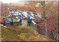
Ach-mhairc Bridge, Glen Tilt
by Jim Barton geograph for square NN8871 A stone bridge over the Allt Mhairc which originates at Loch Mhairc, not far... (more)
Tags:
Autumn ColoursX
type:GeographX
top:PathsX
top:Rivers, Streams, DrainageX
Rowan BerriesX
Stone Bridge Over River
top:UplandsX
WalkersX
|
|
Ladykirk and Norham Bridge over the Tweed (2)
by Jim Barton geograph for square NT8947 The east side of the bridge and the English bank of the Tweed near Norham, seen... (more)
|
|
Old Military Road Bridge over Kinglas Water
by Steve Fareham geograph for square NN2309 A warm sunny May afternoon with the last of the late daffodils.
|
|
Boyndie Bridge, Inverboyndie
by Stanley Howe geograph for square NJ6664 Upstream face of the old stone bridge over the Burn of Boyndie.
Tags:
place:BanffX
top:Rivers, Streams, DrainageX
top:Roads, Road TransportX
Stone Bridge Over River
|

|
Middlebrook Valley Way, Lady Bridge Lane
by M J Roscoe geograph for square SD6808 Combined cycle and pedestrian path and river, Middle Brook, at road bridge; the... (more)
Tags:
type:GeographX
top:PathsX
Public Footpath & CyclewayX
subject:RiverX
top:Rivers, Streams, DrainageX
Stone Bridge Over River
|
|
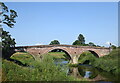
Llandrinio bridge
by Bill Harrison geograph for square SJ2916 The handsome bridge over the River Severn was built in 1775 and is grade-I... (more)
Tags:
road:B4393X
type:GeographX
architect:John GwynnX
river:River SevernX
top:Rivers, Streams, DrainageX
top:Roads, Road TransportX
Stone Bridge Over River
|
|
Polson Bridge over the Tamar
by Des Blenkinsopp geograph for square SX3584 The upstream side of the bridge, looking from Cornwall over to Devon.
A similar... (more)
|
|
The old bridge at Ebchester
by Robert Graham geograph for square NZ1055 This dates from 1862, and carried the old road over the River Derwent into... (more)
Tags:
subject:BridgeX
type:GeographX
RiverX
top:Rivers, Streams, DrainageX
top:Roads, Road TransportX
Stone Bridge Over River
top:Village, Rural SettlementX
|
|
Lintzford bridge
by Robert Graham geograph for square NZ1457 The old 18 century bridge over the River Derwent near Rowlands Gill. It was... (more)
Tags:
subject:BridgeX
type:GeographX
top:LowlandsX
RiverX
top:Rivers, Streams, DrainageX
top:Roads, Road TransportX
Rural HamletX
Stone Bridge Over River
|
|
Telford's Bridge, Invermoriston
by Jim Barton geograph for square NH4116 The modern bridge gives a good view of this early 19th century bridge over the... (more)
Tags:
type:GeographX
top:Historic Sites and ArtefactsX
top:Rivers, Streams, DrainageX
Stone Bridge Over River
|
|
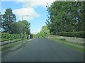
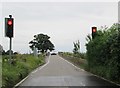
Traffic lights at Cattal Bridge over River Nidd
by Martin Dawes geograph for square SE4454 Minor road goes south towards Tockwith over this "weak bridge"
Tags:
type:GeographX
top:LowlandsX
River NiddX
top:Roads, Road TransportX
Stone Bridge Over River
Traffic LightsX
|
|
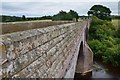
Belah Bridge
by Karl and Ali geograph for square NY7912 A lovely stone bridge spanning (not surprisingly) the River Belah. Now it... (more)
Tags:
top:LowlandsX
top:Rivers, Streams, DrainageX
top:Roads, Road TransportX
Stone Bridge Over River
|
|
Loyn Bridge and Marl Hole Wood
by Karl and Ali geograph for square SD5869 The Lune is running high making the footpath on the east bank through Marl Hole... (more)
Tags:
top:LowlandsX
river:LuneX
top:Rivers, Streams, DrainageX
bridge:Road Over RiverX
top:Roads, Road TransportX
Stone Bridge Over River
top:Woodland, ForestX
|
|
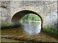
Church Bridge, Dent
by Karl and Ali geograph for square SD7087 The River Dee is very low after a prolonged period with little/no rain.
|
|
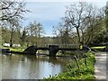
Rievaulx Bridge, one way traffic
by Pauline E geograph for square SE5784 Not that there's much traffic along this minor road. Over the bridge leads... (more)
|