Public Tags
Tag: Stream·Gullies
Showing images tagged with Stream Gullies tag.
|
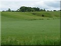
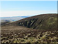
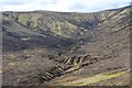
Stream gully, north of Far Hey
by Christine Johnstone geograph for square SD8846 The stream issues at the top of the slope and sinks at the bottom.
|
|
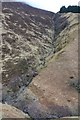
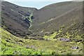
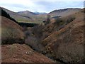
Stream gully, Sgurr an Uillt Tharsuinn
by Jim Barton geograph for square NG9123 A steep and fairly straight gully descending about 300m to the An Leth-allt.
Tags:
Heather and Grass MoorlandX
top:MoorlandX
top:Rivers, Streams, DrainageX
Stream GullyX
top:UplandsX
|
|
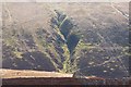
Gully above Saddle Nick
by Jim Barton geograph for square NT0531 The Border hills can be written off as dull and featureless, but there are... (more)
|
|
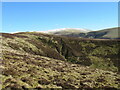
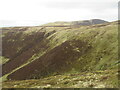
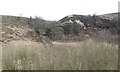
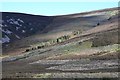
The flank of Bail Hill
by Alan O'Dowd for square NS8611 The shallow gullies at the head of the Bail Gill can be seen, with a snow-dusted... (more)
Tags:
top:Air, Sky, WeatherX
type:Cross GridX
GulliesX
subject:HillsideX
Lowther HillsX
top:MoorlandX
top:Rivers, Streams, DrainageX
SnowX
Southern UplandsX
Stream Gullies
top:UplandsX
|
|
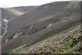
Gullies on White Dod
by Alan O'Dowd for square NS8511 Viewed across Bail Gill from the flanks of Bail Hill.
Tags:
type:Cross GridX
GulliesX
subject:HillsideX
top:MoorlandX
top:Rivers, Streams, DrainageX
Southern UplandsX
Stream Gullies
top:UplandsX
|
|
Gullies at the head of King's Beck
by Alan O'Dowd for square NT0529 The term 'beck', rather than 'burn' is very unusual in... (more)
Tags:
type:Cross GridX
GulliesX
subject:HillsideX
top:MoorlandX
top:Rivers, Streams, DrainageX
Southern UplandsX
Stream Gullies
top:UplandsX
|
|
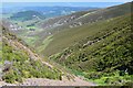
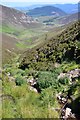
Gullies above Bleak Hope
by Jim Barton geograph for square NT2433 Steep-sided gullies at the head of this secluded side valley off Hundles Hope.
Tags:
BurnsX
CleuchX
type:GeographX
Heather MoorlandX
top:MoorlandX
top:Rivers, Streams, DrainageX
Steep HillsideX
Stream Gullies
top:UplandsX
|
|
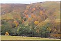
Wooded stream gullies, Glen Tilt
by Jim Barton geograph for square NN8971 A striking example of tree growth in the steeper sides of the streams where the... (more)
|
|
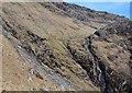
Near the top of Clinty Burn gully
by Jim Barton geograph for square NT2233 Patches of scree near the top of the steeper part of the gully, which merges... (more)
|
|
Stream gully, below Fen Moor
by Christine Johnstone geograph for square SE8497 Seen from a southbound train.
Tags:
subject:MoorlandX
top:MoorlandX
national park:North York MoorsX
Open Access MoorlandX
Stream GullyX
|
|
Berwickshire Landscape : Oaks Beside A Branch Of The Dowlaw Burn
by Richard West geograph for square NT8669 Oak trees in and beside the gully formed by one of the western branches of the... (more)
Tags:
top:LowlandsX
Oak TreesX
top:Rivers, Streams, DrainageX
Stream GullyX
subject:TreeX
top:Woodland, ForestX
|
|
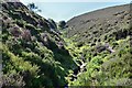
Clinty Burn gully, Glenrath Hill
by Jim Barton geograph for square NT2233 The Border hills are generally considered to be rounded, unexciting lumps, but... (more)
|
|
Clinty Burn from below
by Jim Barton geograph for square NT2234 The gully for this burn looked a more enticing proposition than fighting a way... (more)
|
|
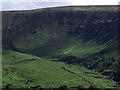
Gullies above Hundles Hope
by Jim Barton geograph for square NT2335 Two burns on the east side of the glen, each with trees established on their steep banks.
Tags:
type:GeographX
Heather MoorlandX
top:MoorlandX
top:Rivers, Streams, DrainageX
Stream Gullies
Trees by a BurnX
top:UplandsX
|
|
Amphitheatre of the Allt Grannda
by Jim Barton geograph for square NH0217 The path to Affric traverses this impressively steep hillside seamed with... (more)
Tags:
type:GeographX
top:MoorlandX
top:PathsX
top:Rivers, Streams, DrainageX
Rock OutcropsX
top:Rocks, Scree, CliffsX
Steep HillsideX
Stream Gullies
top:UplandsX
|
|
Gully with an issue at the top and a sink at the bottom
by Christine Johnstone geograph for square SD9055 Seen from an open window on a southbound train, on the Settle Carlisle line.
|
|
Scawdmans Hill from Crooked Bank
by Jim Barton geograph for square NT0531 The domed symmetry of the hill showing up well from this viewpoint at the head... (more)
|
|
From the top of Clinty Burn gully
by Jim Barton geograph for square NT2233 The extensive view down the valley of Hundles Hope, past Cademuir Hill to the... (more)
|
|
Dry stream bed
by Eirian Evans geograph for square SH6605 Coming down from Mynydd Tan-y-Coed
Tags:
type:GeographX
top:Rivers, Streams, DrainageX
Sheep PastureX
subject:StreamX
Stream GullyX
top:UplandsX
|
|
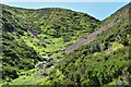
Torside Clough
by Stephen Burton for square SK0697 The largest of the many gashes cut into the Bleaklow plateau by streams taking... (more)
|
|
Upper slopes of Coire Crubaidh
by Jim Barton for square NH0552 The headwaters of the burn draining the corrie between Carn Breac and Coille... (more)
Tags:
CorrieX
type:Cross GridX
Heather and Grass MoorlandX
top:MoorlandX
top:Rivers, Streams, DrainageX
Stream Gullies
top:UplandsX
|
|
Erosion caused by a hillside stream
by Christine Johnstone geograph for square SH6605 Dropping out of Coed Rhiwerfa, towards the B4405.
|
|
Hundles Hope from Clinty Burn
by Jim Barton for square NT2334 A view down to the valley from about half way up the burn, looking out to... (more)
Tags:
Heather MoorlandX
top:MoorlandX
top:Rivers, Streams, DrainageX
Stream GullyX
top:UplandsX
ValleyX
|
|
Course of a tributary of Eller Beck
by Christine Johnstone geograph for square SD9754 Running north-west, on the west side of Grassington Road.
|
|
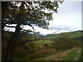
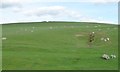
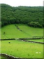
Hazel scrub follows the burn
by Alan Reid geograph for square NN1069 Category: Valley landscape |