Public Tags
Other tags: Rifle Range
former:Rifle Range
Showing latest 50 of 72 images tagged with subject:Rifle Range tag.
|
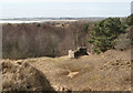
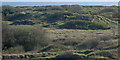
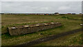
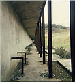
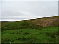
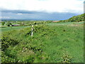
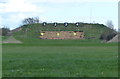
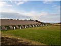
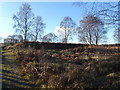
Structure at disused rifle range in the east of Merthyr Mawr Warren (2)
by eswales geograph for square SS8676 Category: Rifle range (disused) Viewed from a different vantage point, the structure at the nineteenth century... (more)
|
|
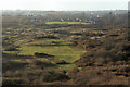
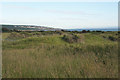
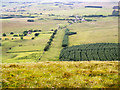
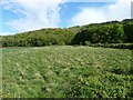
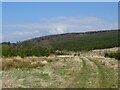
View over disused rifle range in the west of Merthyr Mawr Warren
by eswales for square SS8477 Category: Rifle range (disused) A view from the dune Cog-y-brain over the older and more northerly of two... (more)
|
|
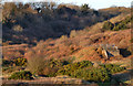
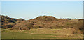
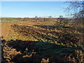
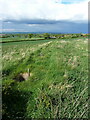
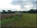
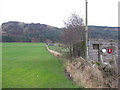
Disused rifle range below Wig Fach
by eswales geograph for square SS8577 Category: Rifle range (disused) View showing, to the right of picture, the butts of a long-disused rifle range... (more)
Tags:
top:Derelict, DisusedX
Disused Rifle RangeX
DunelandX
subject:Rifle Range
Rifle Range ButtsX
TreesX
|
|
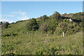
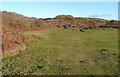
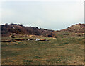
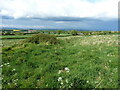
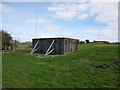
Fenced off former rifle range target area below Wig Fach
by eswales geograph for square SS8577 Category: Rifle range (disused) The large structure where the targets for one of the rifle ranges in the west of... (more)
|
|
Disused rifle range butts in the west of Merthyr Mawr Warren
by eswales geograph for square SS8577 Category: Rifle range (disused) Earthworks at the spot where the targets of the more southerly of two parallel... (more)
|
|
Firing point on disused rifle range below Wig Fach
by eswales geograph for square SS8477 Category: Rifle range (disused) This firing point is situated on the northern of the disused rifle ranges to be... (more)
|
|
On the old rifle range to the south of Wig Fach (2)
by eswales geograph for square SS8477 Category: Rifle range (disused) The photograph shows, in the foreground, an elongated earthwork on the more... (more)
|
|
On the old rifle range to the south of Wig Fach
by eswales geograph for square SS8477 Category: Rifle range (disused) The rifle range, disused for many decades, lying to the west of the high... (more)
|
|
Rifle Range, Old Wick
by Mick Garratt geograph for square ND3648 Canmore.org.uk. (2021). Old Wick, Rifle Range | Canmore. [online] Available at:... (more)
|
|
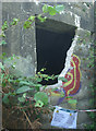
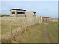
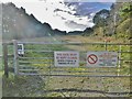
Warning notice at rifle range structure below Wig Fach
by eswales for square SS8577 Seen in 2015 at the rear (east side) of the more northerly of the two rifle... (more)
Tags:
type:Close LookX
top:Derelict, DisusedX
Disused Rifle RangeX
subject:Rifle Range
Rifle Range ButtsX
|
|
Firing point on disused rifle range in the west of Merthyr Mawr Warren
by eswales geograph for square SS8477 Category: Rifle range (disused) The elongated mound seen in the photograph will have been one of the points... (more)
|
|
On the old rifle range to the south of Wig Fach (3)
by eswales geograph for square SS8477 Category: Rifle range (disused) One of several elongated earthworks, probable former firing points, to be seen... (more)
|
|
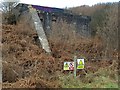
Stop butt structure, East Weares Disused Rifle Range, Portland
by Becky Williamson geograph for square SY7072 From the south-west coast path. The rifle range was built at the beginning of... (more)
Tags:
top:Defence, MilitaryX
top:Derelict, DisusedX
DisusedX
type:GeographX
top:Historic Sites and ArtefactsX
MilitaryX
PortlandX
subject:Rifle Range
Rifle Range
|
|
Firing point on disused rifle range in the west of Merthyr Mawr Warren (2)
by eswales geograph for square SS8477 Category: Rifle range (disused) Part of the firing point which was situated six hundred yards from the targets... (more)
|
|
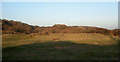
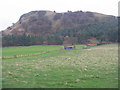
Target Area on an old Rifle Range
by Rab McMurdo geograph for square NS8530 What's left of the target area for the old rifle range was in the centre of... (more)
Tags:
top:Defence, MilitaryX
top:Derelict, DisusedX
type:GeographX
top:Historic Sites and ArtefactsX
top:LowlandsX
top:MoorlandX
subject:Rifle Range
|
|
Rifle range, Kilmuir, Ross And Cromarty
by Claire Pegrum geograph for square NH7672 The 2nd Edition OS map, surveyed in 1904, shows a rifle range in this field, but... (more)
Tags:
top:CoastalX
firth:Cromarty FirthX
top:Defence, MilitaryX
top:Derelict, DisusedX
type:GeographX
subject:Rifle Range
TargetX
|
|
Structure at disused rifle range below Wig Fach in the 1980s
by eswales geograph for square SS8577 This structure is probably the one at the more northerly of the two disused... (more)
|
|
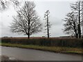
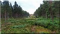
Old rifle range
by Trevor Littlewood geograph for square NY3925 The rifle range is the obvious grassy lane between lines of trees: long disused.
Tags:
Coniferous PlantationX
top:Derelict, DisusedX
Disused Rifle RangeX
type:GeographX
Hill SlopeX
subject:Rifle Range
top:UplandsX
|
|
Rifle Range 'E' view from 300 yard firing position
by John M geograph for square SK0017 The butts at the right of the range were removed after the Second World War with... (more)
Tags:
top:Defence, MilitaryX
type:GeographX
top:Heath, ScrubX
subject:Rifle Range
Rifle Range ButtsX
WWIX
|
|
Wig Fach rifle range and Cwm y Gaer in the 1980s
by eswales geograph for square SS8477 One of the firing points at the more northerly of the two disused ranges below... (more)
Tags:
Cwm Y GaerX
top:Derelict, DisusedX
Disused Rifle RangeX
type:GeographX
subject:Rifle Range
ValleyX
Valley SideX
|
|
300m distance on the range
by Richard Law geograph for square SJ6209 Looking up the (now disused) Wrekin Rifle range, in the opposite direction to... (more)
Tags:
top:Defence, MilitaryX
top:Derelict, DisusedX
type:GeographX
top:Historic Sites and ArtefactsX
subject:Rifle Range
|
|
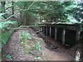
Hythe pattern target frame in the target gallery
by Richard Law geograph for square SJ6308 Deep in the trench of the rifle range's target gallery, 12 of these iron... (more)
|

|
The firing range stop butts
by Richard Law geograph for square SJ6308 10 or 11 years later than SJ6308 : The Butts of the Wrekin Range, and considerably more overgrown, now that... (more)
|
|
Ecclefechan Rifle Range
by Rab McMurdo geograph for square NY2073 The remains of the target area for the old rifle range at Ecclefechan.
Tags:
top:Defence, MilitaryX
top:Derelict, DisusedX
type:GeographX
top:Historic Sites and ArtefactsX
top:LowlandsX
subject:Rifle Range
top:Woodland, ForestX
|
|
Rifle range
by Oscar Taylor for square SU4338 Looking from The Street at the rifle range within the danger area.
|
|
Rifle Range
by Rab McMurdo geograph for square NS8131 This was the target area for an old rifle range near
Douglas West.
This photo... (more)
Tags:
top:Defence, MilitaryX
top:Derelict, DisusedX
type:GeographX
top:GrasslandX
top:LowlandsX
top:MoorlandX
subject:Rifle Range
|
|
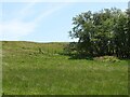
Old Rifle-Range
by Rab McMurdo for square NX8898 Somewhere in that new-ish plantation, about the middle of the photo, there was... (more)
Tags:
type:Cross GridX
top:Defence, MilitaryX
top:Derelict, DisusedX
top:Historic Sites and ArtefactsX
top:LowlandsX
top:MoorlandX
subject:Rifle Range
top:Woodland, ForestX
|
|
The 200m firing ridge
by Richard Law geograph for square SJ6209 Located 200m from the butts, with a series of fox-holes (there are sticks poking... (more)
Tags:
top:Defence, MilitaryX
top:Derelict, DisusedX
type:GeographX
top:Historic Sites and ArtefactsX
subject:Rifle Range
|
|
The 200m firing ridge
by Richard Law geograph for square SJ6209 Located 200m from the butts, with a series of fox-holes each of which held an... (more)
Tags:
top:Defence, MilitaryX
top:Derelict, DisusedX
type:GeographX
top:Historic Sites and ArtefactsX
subject:Rifle Range
|
|
The 100m firing ridge
by Richard Law geograph for square SJ6209 Located 100m from the butts, with a series of fox-holes (the stick is poking out... (more)
Tags:
top:Defence, MilitaryX
top:Derelict, DisusedX
type:GeographX
top:Historic Sites and ArtefactsX
subject:Rifle Range
|
|
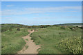
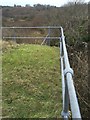
Crossing a rifle range on the Whittington military area
by Richard Law geograph for square SK1607 The public bridleway here crosses directly over a long rifle range, at roughly... (more)
|
|
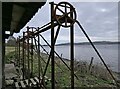
Bogend Rifle Range
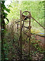
by Rab McMurdo geograph for square NS5324 Target pulleys behind the butts at the old Bogend Rifle Range.
Tags:
top:Defence, MilitaryX
top:Derelict, DisusedX
type:GeographX
top:LowlandsX
subject:Rifle Range
top:Rivers, Streams, DrainageX
top:Woodland, ForestX
|
|
Target for Volunteers' Rifle Range
by Mick Garratt geograph for square NC8903 Canmore.org.uk. (2021). Strathsteven | Canmore. [online] Available at:... (more)
|
|
Oundle School Rifle Range
by Mat Fascione geograph for square TL0689 |
|
Sentry post at Whitburn
by Oliver Dixon geograph for square NZ4163 Sentry post beside the England Coast Path at Whitburn. The post controls access... (more)
Tags:
top:Defence, MilitaryX
Long Distance PathX
National TrailX
PathX
top:PathsX
Rifle Range
subject:Rifle Range
Sentry PostX
|
|
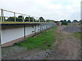
Rifle Range Butts
by Alan Hughes geograph for square SS8577 Generations of youngsters have played in, on and around these disused WW2 rifle... (more)
|
|
Rifle Range Butts
by Alan Hughes geograph for square SS8577 World War 2 rifle range butts at Merthyrmawr warren.
|
|
Rifle Range, Achneim Wood
by Mick Garratt geograph for square NH8547 |
|
Rifle range near Elmington Top Lodge, Ashton
by Richard Humphrey geograph for square TL0689 |

|
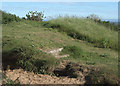
Rifle Range?
by David Chatterton geograph for square NT9249 According to old maps (OS 6 inch 1888-1913) there was once a rifle range here,... (more)
|
|
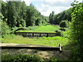
Blairadam Range and Benarty Hill
by M J Richardson geograph for square NT1397 Looking up the range to the butts under Bibb Wood and Mulla Craig. The range has... (more)
Tags:
Benarty HillX
BlairadamX
top:Defence, MilitaryX
top:Farm, Fishery, Market GardeningX
top:LowlandsX
PastureX
place:Perth and KinrossX
Rifle Range
subject:Rifle Range
top:Sport, LeisureX
top:UplandsX
|
|
Target gallery at the rifle range
by Richard Law geograph for square SK1607 The metal frames are very similar in construction to these SJ6308 : Hythe pattern target frame in the target gallery and... (more)
|
|
Fort George Rifle Range
by valenta geograph for square NH7657 Access through the range is possible when the red flag is not flying, denoting... (more)
Tags:
place:ArdersierX
top:CoastalX
top:Defence, MilitaryX
top:Estuary, MarineX
place:Fort GeorgeX
type:GeographX
top:Historic Sites and ArtefactsX
subject:Rifle Range
|
|
East Holme, warning signs
by Mike Faherty geograph for square SY9184 At the approach to East Holme Rifle Range, on the Lulworth Ranges. The butts are... (more)
Tags:
top:Defence, MilitaryX
type:GeographX
top:LowlandsX
subject:Rifle Range
subject:SignX
top:Woodland, ForestX
|

|
Shooting range, Castlelaw Hill
by Mick Garratt geograph for square NT2264 |
|
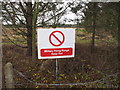
Firing range warning sign, Alcar
by David Hawgood geograph for square SD2905 The Altcar training camp has a number of rifle ranges and accommodation for over... (more)
Tags:
top:Defence, MilitaryX
subject:Rifle Range
|
|
The length of the rifle range
by Martin Dawes geograph for square SE8086 Only open on Sunday, no stray bullets midweek, the footpath goes down the... (more)
Tags:
FootpathX
type:GeographX
top:LowlandsX
top:PathsX
subject:Rifle Range
top:Sport, LeisureX
top:Woodland, ForestX
WoodsX
|
|
Rifle Range 'E' 300 yard firing position
by John M geograph for square SK0017 The original Great War range had 48 targets.
|
|
Blairadam Range
by M J Richardson geograph for square NT1397 Beneath the west end of Benarty Hill - in continuous use since the 1870s NT1397 : History of the Blairadam Range.
Tags:
Benarty HillX
BlairadamX
top:Defence, MilitaryX
top:LowlandsX
PastureX
place:Perth and KinrossX
subject:Rifle Range
Rifle Range
top:Sport, LeisureX
top:UplandsX
top:Woodland, ForestX
|
|
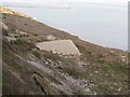
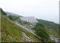
Grove, rifle range
by Mike Faherty geograph for square SY7072 The bulk of the disused range, with the outline of Portland Harbour in the misty distance.
Tags:
top:CoastalX
top:Defence, MilitaryX
top:Derelict, DisusedX
top:Heath, ScrubX
subject:Rifle Range
top:Rocks, Scree, CliffsX
|