Public Tags
Showing latest 50 of 732 images tagged with subject:Stable tag.
|
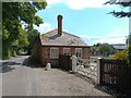
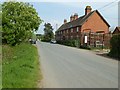
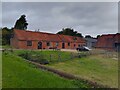
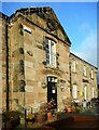
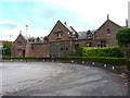
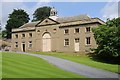
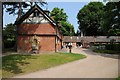
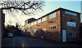
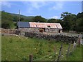
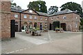
Polhampton Lodge Stud buildings
by Oscar Taylor geograph for square SU5154 Looking from Kingsclere Road (the B3051) at buildings and stables at Polhampton... (more)
Tags:
top:Farm, Fishery, Market GardeningX
type:GeographX
top:Roads, Road TransportX
subject:Stable
top:Woodland, ForestX
|
|
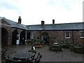
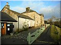
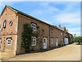
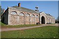
Polhampton Lodge Stud stables
by Oscar Taylor geograph for square SU5154 Stables at Polhampton Lodge Stud off the B3051 (Kingsclere Road).
The stables... (more)
Tags:
top:Farm, Fishery, Market GardeningX
type:GeographX
top:Housing, DwellingsX
top:Roads, Road TransportX
subject:Stable
top:Village, Rural SettlementX
|
|
Stables, Lloyd Park
by Malc McDonald geograph for square TQ3790 Former stables in Lloyd Park, in Walthamstow.
Tags:
Former StablesX
type:GeographX
Horse StablesX
place:North East LondonX
Old StablesX
ParkX
top:Park and Public GardensX
subject:Stable
StablesX
Stables (Former)X
place:WalthamstowX
|
|
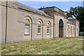
Stable block, Nostell Priory
by Philip Halling geograph for square SE4017 The stable block at Nostell Priory was built during two periods, in 1770-1776 by... (more)
Tags:
type:GeographX
Grade I ListedX
top:Historic Sites and ArtefactsX
National Trust PropertyX
Nostell PrioryX
subject:Stable
Stable BlockX
|
|
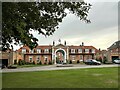
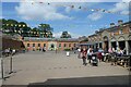
Staunton Harold Stables
by Oliver Mills geograph for square SK3720 A stable block from a historic estate, redeveloped into shops. These include an... (more)
Tags:
top:Business, Retail, ServicesX
subject:CafeX
top:Country EstatesX
subject:CourtyardX
type:GeographX
top:Historic Sites and ArtefactsX
top:Public Buildings and SpacesX
subject:ShopX
subject:Stable
Stable BlockX
Staunton HaroldX
top:Village, Rural SettlementX
|
|
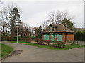
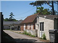
Old Stables, Burnham-on-Sea
by PAUL FARMER geograph for square ST3049 Tags:
place:Burnham-on-SeaX
top:City, Town CentreX
Former StablesX
type:GeographX
top:Historic Sites and ArtefactsX
Mounting StepsX
Old StablesX
SomersetX
county:SomersetX
subject:Stable
Stables (Former)X
Stables BlockX
|
|
The Stables, Kenilworth Castle
by Philip Halling geograph for square SP2772 The Stables at Kenilworth Castle were built in 1553 for John Dudley, Duke of... (more)
|
|
The Stables, Kenilworth Castle
by Philip Halling geograph for square SP2772 The Stables at Kenilworth Castle were built in 1553 for John Dudley, Duke of... (more)
|
|
Stables in Kinnersley
by Philip Halling geograph for square SO8643 Racing stables in Kinnersley, the stable is now run by John Spearing, formerly... (more)
|
|
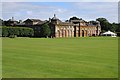
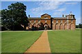
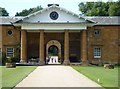
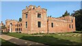
The Stables, Houghton Hall
by Philip Halling for square TF7928 The Stables of Houghton Hall were built in 1733-5 for Sir Robert Walpole. These... (more)
|
|
The Stables, Houghton Hall
by Philip Halling geograph for square TF7928 The Stables of Houghton Hall were built in 1733-5 for Sir Robert Walpole. These... (more)
|
|
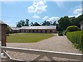
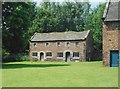
Stables to the west of Barn Cottages, Dunham Massey
by Richard Sutcliffe geograph for square SJ7387 Grade II listed stables... (more)
|
![SX5255 : Saltram House and garden [18] by Michael Dibb](https://s2.geograph.org.uk/geophotos/07/62/93/7629394_74b487bb_120x120.jpg)
|
Saltram House and garden [18]
by Michael Dibb for square SX5255 Some original stalls within the stable block. This part is used as a second-hand... (more)
|
![SX5255 : Saltram House and garden [17] by Michael Dibb](https://s3.geograph.org.uk/geophotos/07/62/93/7629391_2bcf2a69_120x120.jpg)
|
Saltram House and garden [17]
by Michael Dibb geograph for square SX5255 The coach house section of the stable block. The stable block, coachman's... (more)
|
|
South Stanmore Farm stable
by Oscar Taylor geograph for square SU4778 A red brick stable with red tile roof, the stable now has brown UPVC windows and... (more)
Tags:
top:Farm, Fishery, Market GardeningX
type:GeographX
top:Roads, Road TransportX
subject:Stable
top:Village, Rural SettlementX
|
|
Killerton stable block
by David Smith geograph for square SS9700 Showing the chimneys for the accommodation of stable workers
Tags:
type:GeographX
top:Historic Sites and ArtefactsX
top:Housing, DwellingsX
National Trust PropertyX
subject:Stable
Stable BlockX
StablesX
|
|
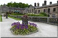
Stable courtyard, Calcot Court
by Simon Mortimer geograph for square SU6772 The house and stable yard were built in 1755 for Sir John Blagrave and have... (more)
|
|
Lambhill Stables
by Richard Sutcliffe geograph for square NS5869 Category B listed Link
Tags:
Bike RepairsX
top:CanalsX
Former StablesX
Forth and Clyde CanalX
type:GeographX
top:Historic Sites and ArtefactsX
subject:Stable
|
|
Lambhill Stables
by Richard Sutcliffe for square NS5869 Category B listed Link
Tags:
top:CanalsX
type:Close LookX
Former StablesX
Forth and Clyde CanalX
top:Historic Sites and ArtefactsX
subject:Stable
|
|
Lambhill Stables
by Richard Sutcliffe geograph for square NS5869 Category B listed Link
Tags:
top:CanalsX
Former StablesX
Forth and Clyde CanalX
type:GeographX
top:Historic Sites and ArtefactsX
subject:Stable
|
|
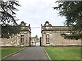
Stable yard
by Bob Harvey geograph for square SK5717 These gates give entrance to a stable yard in South Street, Barrow-upon-Soar,... (more)
Tags:
place:Barrow Upon SoarX
Dashcam ImageX
type:GeographX
top:Historic Sites and ArtefactsX
period:Late 19th CenturyX
listed building status:Locally ListedX
Locally ListedX
top:LowlandsX
subject:Stable
Stable YardX
top:Suburb, Urban FringeX
|
|
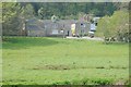
Burnt out stables at Walton Hall
by Simon Mortimer geograph for square TM2836 The buildings originally formed part of the farm at Walton Hall. Recently they... (more)
Tags:
top:Construction, DevelopmentX
top:Farm, Fishery, Market GardeningX
type:GeographX
subject:Stable
ruin:StablesX
Stables (Former)X
top:Suburb, Urban FringeX
|
|
The former stable block building at Lilleshall Hall
by Richard Law geograph for square SJ7414 Built in 1829/1830 (so at the same time as the magnificent main hall... (more)
|
|
The Stables, Penrose Estate
by Philip Halling geograph for square SW6425 The former stables on the Penrose estate date from the late 18th century, today... (more)
|
|
Converted stable block, Stow Hall, Norfolk
by Richard Humphrey geograph for square TF6305 Tags:
top:Country EstatesX
Former StablesX
type:GeographX
HousesX
NorfolkX
subject:Stable
StablesX
Stables (Former)X
|
|
Stables at Hall Farm Horse Rescue Centre
by Geographer geograph for square TL9990 |
|
Stables at Shipton Hall
by Philip Halling geograph for square SO5691 The Stables at Shipton Hall date from 1756-7 and are more than 150 years later... (more)
Tags:
type:GeographX
Grade II ListedX
top:Historic Sites and ArtefactsX
subject:Stable
Stable BlockX
StablesX
|
|
Entrance to former stable block at Longleat
by Jonathan Hutchins for square ST8043 The stable block is Grade I listed, see... (more)
Tags:
top:Country EstatesX
type:Cross GridX
Former Stable BlockX
Longleat ParkX
subject:Stable
former:Stable BlockX
|
|
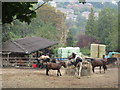
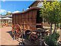
Temporary stabling at Eland Lodge Horse Trials
by Jonathan Hutchins geograph for square SK1427 Constructed to accommodate the horses of competitors who have to stay overnight... (more)
Tags:
AnvilX
Eland Lodge Horse TrialsX
Farriers VanX
type:GeographX
top:People, EventsX
top:Sport, LeisureX
subject:Stable
Stable BlockX
StablingX
Temporary StablingX
|
|
The Stables, Attingham Park
by Philip Halling for square SJ5409 The south facade of the Stables at Attingham Park.
|
|
Stable block, Wightwick Manor
by Philip Halling geograph for square SO8698 Today the stable block as Wightwick Manor houses toilets and a tearoom.
|
|
The Stables, Killerton House
by Philip Halling geograph for square SS9700 The stables are situated to the east of Killerton House and these days contain a... (more)
|
|
Looking through the stable block at Althorp House
by Richard Humphrey geograph for square SP6865 |
|
The stable block at Althorp House
by Richard Humphrey geograph for square SP6865 |
|
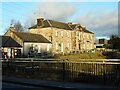
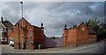
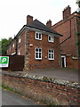
Windmill Lane, Mansfield, Notts.
by David Hallam-Jones geograph for square SK5461 The former Carr Bank House stables, c.1805. A corner of the main house (now The... (more)
Tags:
top:Business, Retail, ServicesX
Former Carr Bank HouseX
Former StablesX
top:Historic Sites and ArtefactsX
top:Park and Public GardensX
top:Sport, LeisureX
subject:Stable
top:Suburb, Urban FringeX
|
|
Stables in the City
by David Anstiss geograph for square TQ3457 This stables along Church Road is close to the London suburb of Whyteleafe.... (more)
Tags:
top:Farm, Fishery, Market GardeningX
subject:Stable
|
|
Former Stable Block at Swattenden Centre
by Oast House Archive geograph for square TQ7734 Category: Stables A former stable block near to footpath from Attwater Farm to Swattenden Lane.
Tags:
top:Sport, LeisureX
subject:Stable
|
|
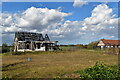
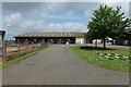
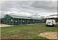
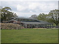
New Stable Building at Raystede
by Oast House Archive for square TQ4714 Category: Stables Large steel framed stable building under construction at Raystede.
Tags:
top:Sport, LeisureX
subject:Stable
|
|
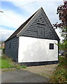
Gwastadfryn stables
by Rudi Winter geograph for square SH6709 Category: Stables The stables belonging to Gwastadfryn farm at the bottom of the Afon Cadair... (more)
Tags:
top:Sport, LeisureX
subject:Stable
|
|
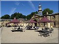
Stable Yard, Tatton Park
by Eirian Evans geograph for square SJ7481 Tatton Park is owned by the National Trust who have restaurant at The Stables.... (more)
Tags:
top:Business, Retail, ServicesX
type:GeographX
Listed BuildingX
top:Park and Public GardensX
subject:Stable
StableyardX
Visitor AttractionX
|
|
The Stables at Felbrigg Hall
by Sandy Gerrard geograph for square TG1939 Link
Tags:
top:Country EstatesX
type:GeographX
top:Historic Sites and ArtefactsX
top:LowlandsX
subject:Stable
Stable
Stable BlockX
|
|
Stable block and Gardener's Cottages
by Philip Halling geograph for square SK1350 Stable Block is to the rear with the Gardener's Cottages on the right,... (more)
|
|
Stable block, Beningborough Hall
by Philip Halling geograph for square SE5158 The stable block is situated to the east of the hall and is Grade II listed,... (more)
Tags:
type:GeographX
top:Historic Sites and ArtefactsX
National Trust PropertyX
subject:Stable
Stable BlockX
|
![SX5255 : Saltram House and garden [16] by Michael Dibb](https://s1.geograph.org.uk/geophotos/07/62/93/7629389_f2a30a9c_120x120.jpg)
|
Saltram House and garden [16]
by Michael Dibb geograph for square SX5255 This stable block, coachman's cottage and coach house was built in the mid... (more)
|
|
Former stable block to Abbey House
by Richard Law geograph for square SJ4912 Built at the same time, around 1720, as the big house to which it's loosely... (more)
Tags:
top:Business, Retail, ServicesX
top:City, Town CentreX
type:GeographX
top:Historic Sites and ArtefactsX
subject:Stable
|
|
Former stables near The White House
by Richard Law geograph for square SJ4409 Located effectively in the garden of SJ4409 : The White House in Hanwood, this is a set of late 17th... (more)
Tags:
top:Farm, Fishery, Market GardeningX
type:GeographX
top:Historic Sites and ArtefactsX
subject:Stable
top:Village, Rural SettlementX
|
|
A game carriage in the old stable yard at Sandringham House
by Richard Humphrey for square TF6928 Tags:
type:Close LookX
top:Country EstatesX
Game CarriageX
King Charles IIIX
NorfolkX
Sandringham HouseX
subject:Stable
Stable YardX
StablesX
|
|
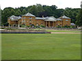
Stables block at Attingham Park
by DS Pugh geograph for square SJ5409 Looking across the stable block at the large country estate.
|
|
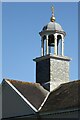
Bellcote on Saltram stable block
by Philip Halling for square SX5255 The bellcote, dome and finial on Saltram stable block. The building is Grade... (more)
Tags:
BellcoteX
type:Close LookX
top:Country EstatesX
Grade II(star) ListedX
top:Historic Sites and ArtefactsX
subject:Stable
Stable BlockX
|
|
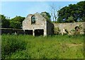
Former stables, Innergellie
by Richard Sutcliffe geograph for square NO5705 The ruins of the Category B listed... (more)
Tags:
top:Derelict, DisusedX
Former StablesX
type:GeographX
top:Historic Sites and ArtefactsX
subject:Stable
|