Public Tags
Tag: Torridonian·Sandstone
Showing latest 50 of 94 images tagged with Torridonian Sandstone tag.
|
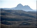
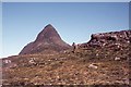
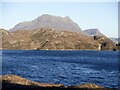
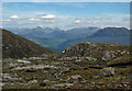
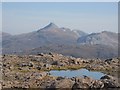
Gneiss and Suilven
by Richard Webb geograph for square NC0718 An inselberg of very old Torridonian sandstone. A mere baby compared with the... (more)
Tags:
type:GeographX
top:Geological InterestX
GneissX
InselbergX
top:MoorlandX
top:Rocks, Scree, CliffsX
p150 hill:SuilvenX
Torridonian Sandstone
|
|
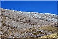
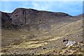
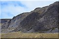
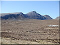
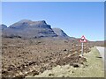
Sandstone and quartzite, Maol Chean-dearg
by Jim Barton for square NG9249 A clear transition is visible from Torridonian sandstone to Cambrian quartzite... (more)
Tags:
type:Cross GridX
top:Geological InterestX
HillsideX
Mountain SceneX
QuartziteX
top:Rocks, Scree, CliffsX
Torridonian Sandstone
top:UplandsX
|
|
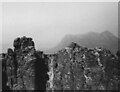
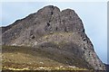
Summit ridge of Stac Pollaid, view to Cul Mor, 1968
by David Hawgood geograph for square NC1010 The mountain "Stac Polly" has a castellated ridge of Torridonian... (more)
Tags:
type:GeographX
top:Geological InterestX
subject:MountainX
Stac PollaidhX
Torridonian Sandstone
top:UplandsX
|
|
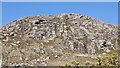
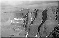
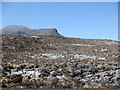
Creag Dhubh
by Richard Webb geograph for square NC1406 Torridonian sandstone crag above the Achiltibuie road.
|
|
Creag Dhubh
by Richard Webb geograph for square NC1406 Torridonian sandstone crag above the Achiltibuie road.
Tags:
type:GeographX
top:Geological InterestX
top:MoorlandX
top:Rocks, Scree, CliffsX
Torridonian Sandstone
|
|
Torridonian sandstone
by Richard Webb geograph for square NC1405 Hillside above the
Tags:
type:GeographX
top:Geological InterestX
top:MoorlandX
top:Rocks, Scree, CliffsX
Torridonian Sandstone
|
|
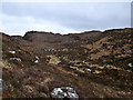
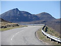
Drumrunie to Achiltiebuie Road
by Richard Webb geograph for square NC1605 Fortunately not signposted as part of the Sheep Track 500, a very scenic route... (more)
Tags:
type:GeographX
top:Geological InterestX
top:MoorlandX
top:Rocks, Scree, CliffsX
Torridonian Sandstone
|
|
The Horns of Alligin
by Jim Barton for square NG8761 Looking back to the last of the three Horns on the east ridge with Beinn Dearg,... (more)
Tags:
Beinn AlliginX
type:Cross GridX
RidgeX
top:Rocks, Scree, CliffsX
TorridonX
Torridonian Sandstone
top:UplandsX
|
|
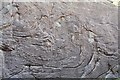
Billion-year-old rock art, Coire nan Arr
by Jim Barton for square NG8043 Patterns in Torridonian sandstone on the face of the right-hand boulder shown in... (more)
Tags:
BouldersX
type:Close LookX
top:Geological InterestX
top:Rocks, Scree, CliffsX
Torridonian Sandstone
top:UplandsX
|
|
The Russel Burn
by Jim Barton geograph for square NG8141 The burn just downstream from Drochaid Coire nan Arr, flowing over Torridonian sandstone.
|
|
Rocky bed of the Abhainn Coire Mhic Nobuil
by Jim Barton geograph for square NG8758 The characteristic grey and pink hues of Torridonian sandstone showing up in the... (more)
|
|
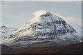
Sail Gharbh, Quinag
by Jim Barton for square NC2129 A light snow cover down to about 400m picks out the features on this impressive... (more)
|
|
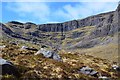
Coire a' Chaorachain
by Jim Barton geograph for square NG7942 The headwall of the corrie showing characteristic Torridonian sandstone terraces.
|
|
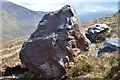
Torridonian sandstone boulder
by Jim Barton geograph for square NG7942 A natural sculpture that gave some shelter from the rain shower shown in NG7942 : Shower coming!.
|
|
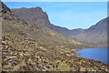
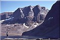
Central and West Buttresses, Coire Mhic Fhearchair
by Jim Barton geograph for square NG9460 Three magnificent N-facing buttresses, 300m in height, dominate the coire. The... (more)
|
|
Sàil Gharbh
by Richard Webb for square NC2129 The highest of the three main tops of Quineag seen from the road to the east.... (more)
Tags:
CragsX
type:Cross GridX
top:Geological InterestX
top:MoorlandX
QuineagX
top:Rocks, Scree, CliffsX
p600 hill:Sail GarbhX
Torridonian Sandstone
|
|
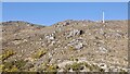
Approaching Meall Beag, Suilven
by Jim Barton geograph for square NC1717 Passing a Torridonian sandstone outcrop on the moorland ridge below... (more)
Tags:
type:GeographX
Heather MoorlandX
top:MoorlandX
top:Rocks, Scree, CliffsX
Torridonian Sandstone
top:UplandsX
WalkerX
|
|
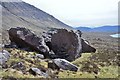
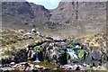
Massive boulders, Coire nan Arr
by Jim Barton geograph for square NG8043 A striking group of Torridonian sandstone boulders about 4m high, giving a rough... (more)
Tags:
BouldersX
type:GeographX
Grass and Heather MoorlandX
top:MoorlandX
top:Rocks, Scree, CliffsX
Torridonian Sandstone
top:UplandsX
|
|
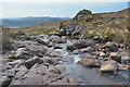
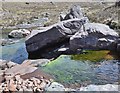
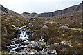
Allt Coire nan Arr
by Jim Barton geograph for square NG7943 A beautiful mountain burn where it encounters several small steps in the... (more)
Tags:
BurnX
type:GeographX
Grass and Heather MoorlandX
top:MoorlandX
top:Rivers, Streams, DrainageX
top:Rocks, Scree, CliffsX
Torridonian Sandstone
top:UplandsX
WaterfallX
|
|
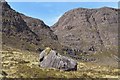
Rocky walls around Coire nan Arr
by Jim Barton geograph for square NG7943 Torridonian sandstone terraces form the west side of the coire. The boulder is... (more)
Tags:
type:GeographX
top:MoorlandX
Rock ButtressesX
top:Rocks, Scree, CliffsX
Rocky HillsideX
Torridonian Sandstone
top:UplandsX
|
|
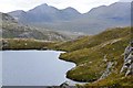
Looking into Coire nan Arr
by Jim Barton geograph for square NG8041 The very steep buttress ahead is the Cioch of Sgurr a' Chaorachain, the end... (more)
Tags:
CragsX
type:GeographX
Heather and Grass MoorlandX
top:Lakes, Wetland, BogX
LochanX
top:MoorlandX
top:Rocks, Scree, CliffsX
Torridonian Sandstone
top:UplandsX
|
|
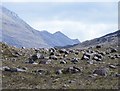
Boulders in Coire Mhic Nobaill
by Jim Barton for square NG9059 Scattered Torridonian sandstone boulders, presumably left by the melting glacier... (more)
|
|
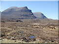
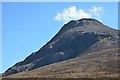
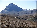
Maol Chean-dearg from the northwest
by Jim Barton geograph for square NG9150 The hill is predominantly torridonian sandstone from this angle.
Tags:
type:GeographX
HillsideX
top:MoorlandX
Mountain SceneX
top:Rocks, Scree, CliffsX
Torridonian Sandstone
top:UplandsX
|
|
Quinag from Loch Bealach a' Bhuirich
by Jim Barton geograph for square NC2628 The three main rock types of Assynt are in view here: Lewisian gneiss in the... (more)
|
|
Allt Coire na Caorach
by Jim Barton geograph for square NG7942 The burn draining this fine corrie on the east side of Sgurr a'... (more)
|
|
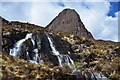
Waterfalls and the Cioch, Sgurr a' Chaorachain
by Jim Barton geograph for square NG8042 The Allt Coire na Caorach (stream of the corrie of the sheep) cascades over... (more)
|
|
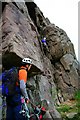
Climbers on the Cioch Nose
by Toby Speight geograph for square NG7942 Category: Crags The Torridonian Sandstone gives very good climbing. The large ledge masks the... (more)
Tags:
person:Chris BoningtonX
ClimbersX
bucket:PeopleX
top:Sport, LeisureX
person:Tom PateyX
Torridonian Sandstone
top:UplandsX
|
|
Cairn on sandstone slab
by Jim Barton geograph for square NH0881 A marker cairn on a Torridon sandstone slab. Note that the path here (or a... (more)
|
|
Shallow sandstone valley
by Toby Speight geograph for square NG7255 Category: Valley One of many undulations in the hillside.
|
|
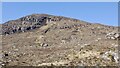
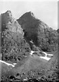
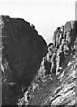
Sandstone rocky cliffs of Stac Pollaidh, 1968
by David Hawgood geograph for square NC1010 Cliffs and castellated ridge.
Tags:
subject:CliffX
type:GeographX
top:Geological InterestX
Stac PollaidhX
Torridonian Sandstone
top:UplandsX
|
|
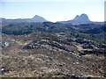
Canisp and Suilven
by Richard Webb geograph for square NC0923 It is worth struggling with the heather to get up one of the small gneiss hills... (more)
|
|
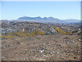
North Assynt gneiss
by Richard Webb geograph for square NC0923 A view across the flat looking, but extremely rough and knobbly Lewisian gneiss... (more)
Tags:
type:GeographX
top:Geological InterestX
GneissX
top:Heath, ScrubX
InselbergX
top:MoorlandX
top:Rocks, Scree, CliffsX
Torridonian Sandstone
|
|
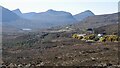
Loch Buine Mòire
by Richard Webb geograph for square NC0915 Lewisian gneiss scenery on the Mad Road of Coigach with a sandstone inselberg... (more)
Tags:
p600 hill:Cul MorX
type:GeographX
top:Geological InterestX
top:Lakes, Wetland, BogX
loch:Loch Buine MoireX
top:MoorlandX
top:Rocks, Scree, CliffsX
Torridonian Sandstone
|
|
Coire nan Arr
by Jim Barton geograph for square NG7943 The corrie floor is littered with boulders, some several metres high, and ringed... (more)
|
|
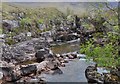
Allt Coire nan Arr
by Jim Barton geograph for square NG7943 The corrie burn encountering some sandstone steps on its way down to the loch.
|
|
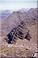
The Triple Buttress, Coire Mhic Fhearchair
by Jim Barton for square NG9460 These magnificent sandstone and quartzite cliffs are showing up well in the... (more)
|
|
Crag on Beinn Dubh a' Bhealaich
by Richard Dorrell geograph for square NG7318 There is much exposed sandstone on the top of this hill. In places it lies in... (more)
Tags:
CragX
top:Geological InterestX
place:Isle of SkyeX
subject:RockX
top:Rocks, Scree, CliffsX
Torridonian Sandstone
|
|
Cliffs of Na Ciochan
by Jim Barton geograph for square NG7942 The cliffs on the north side of Coire a' Chaorachain.
|
|
The Cioch, Sgurr a' Chaorachain
by Jim Barton geograph for square NG7942 The steep end of the spur projecting from the main ridge, forming the northern... (more)
|
|
Triple Buttresses, Coire Mhic Fhearchair
by Jim Barton for square NG9460 These impressive buttresses seen from the summit of Sail Mhor.
|
|
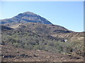
The west summit of Beinn na h-Eaglaise
by Richard Webb geograph for square NG9051 Category: Mountains Beinn na h-Eaglaise is a smaller Torridon hill, south of the settlements at the... (more)
|
|
Quineag from the Lairig Unapool
by Richard Webb geograph for square NC2327 Quineag has three major tops with unusually deep cols between them, making it a... (more)
Tags:
type:GeographX
top:Geological InterestX
top:MoorlandX
QuartziteX
p150 hill:Sail GharbhX
p150 hill:Spidean CoinichX
Torridonian Sandstone
|
|
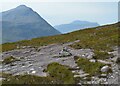
Quartzite moorland
by Richard Webb geograph for square NC2328 A lot of exposed rock in this important Moine Thrust location. Quineag in the... (more)
Tags:
type:GeographX
top:Geological InterestX
top:MoorlandX
QuartziteX
QuineagX
top:Rocks, Scree, CliffsX
p150 hill:Sail GharbhX
Torridonian Sandstone
|
|
Climb to the Lairig Unapool
by Richard Webb geograph for square NC2329 A bend in the steep ascent of the pass, with Quineag ahead - two of the tops... (more)
Tags:
CragsX
type:GeographX
QuineagX
top:Roads, Road TransportX
top:Rocks, Scree, CliffsX
p600 hill:Sail GarbhX
p150 hill:Sail GhormX
Torridonian Sandstone
|
|
A894 and Quineag
by Richard Webb geograph for square NC2329 The road crossing bogland beneath Sàil Gharbh, the highest top of Quineag.
Tags:
CragsX
type:GeographX
top:Geological InterestX
top:Lakes, Wetland, BogX
top:MoorlandX
QuineagX
top:Roads, Road TransportX
top:Rocks, Scree, CliffsX
p600 hill:Sail GarbhX
Torridonian Sandstone
|
|
By Gleannan nan Caorach
by Richard Webb geograph for square NC2131 Looking over the lip of Gleannan nan Caorach towards Sàil Gharbh the highest of... (more)
|
|
Sàil Ghorm
by Richard Webb for square NC2030 The northern summit of Quineag with a waterfall on the Allt a' Ghamhna.
Tags:
type:Cross GridX
QuineagX
top:Rivers, Streams, DrainageX
top:Rocks, Scree, CliffsX
p150 hill:Sail GhormX
Torridonian Sandstone
WaterfallX
top:Woodland, ForestX
|
|
View of Suilven
by Richard Webb geograph for square NC0915 From near the Boat Bay portage route from the Strathpolly to Lochinver road.
Tags:
type:GeographX
top:Geological InterestX
top:MoorlandX
top:Rocks, Scree, CliffsX
p150 hill:SuilvenX
Torridonian Sandstone
|
|
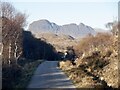
Strathpolly to Lochinver road
by Richard Webb geograph for square NC0914 Facing Suilven. The hill is quite a way in from the road.
Tags:
type:GeographX
top:Geological InterestX
top:Roads, Road TransportX
p150 hill:SuilvenX
Torridonian Sandstone
top:Woodland, ForestX
|
|
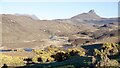
Strath Polly, Coigach
by Richard Webb geograph for square NC0712 A view from the Lochinver to Achiltibuie road towards Stac Pollaidh.
Tags:
type:GeographX
top:Geological InterestX
top:Heath, ScrubX
top:MoorlandX
river:River PollyX
top:Rivers, Streams, DrainageX
p150 hill:Stac PollaidhX
Torridonian Sandstone
|