Public Tags
Tag: Trees·by·a·Track
Showing images tagged with Trees by a Track tag.
|
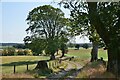
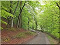
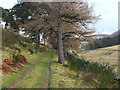
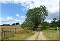
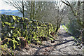
Track on North Lochbrowmoor
by Jim Barton geograph for square NY0889 Some magnificent trees border this track through farmland, also the route of the... (more)
Tags:
long distance path:Annandale WayX
top:Farm, Fishery, Market GardeningX
FarmlandX
type:GeographX
top:PathsX
top:Roads, Road TransportX
Trees by a Track
|
|
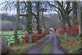
Venlaw track
by Jim Barton geograph for square NT2541 The track to Mailingsland Hill and Shieldgreen, though the latter destination... (more)
|
|
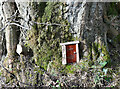
Fairy door near Warkworth
by Jim Barton for square NU2405 There was a hermitage across the River Coquet, but here is evidence of a fairy... (more)
|
|
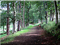
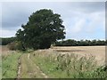
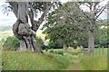
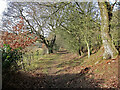
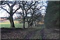
Track through hill pasture, Glen Estate
by Jim Barton geograph for square NT2932 Trees line the track from the farm near Glen House to Glenshiel Banks.
Tags:
top:Country EstatesX
top:Farm, Fishery, Market GardeningX
type:GeographX
Hill PastureX
TrackX
Trees by a Track
|
|
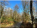
New leaves along the Glenbield track
by Jim Barton geograph for square NT2640 Despite the cold wet spring weather, the trees are showing their magnificent... (more)
Tags:
type:GeographX
New LeavesX
top:Roads, Road TransportX
TrackX
Trees by a Track
top:Woodland, ForestX
|
|
Tree at a bend in the track from Bluestone Farm
by Christine Johnstone geograph for square TF8436 Looking westwards.
Tags:
type:GeographX
Other Route with Public AccessX
top:Roads, Road TransportX
subject:TreeX
Trees by a Track
|
|
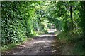
The Cumbria way near Torver Jetty
by Adrian Taylor geograph for square SD3094 North of the footbridge near Torver Jetty, northbound walkers on The Cumbria Way... (more)
Tags:
CumbriaX
Cumbria WayX
ldp:Cumbria WayX
type:GeographX
top:PathsX
Public FootpathX
top:Roads, Road TransportX
ldp:The Cumbria WayX
long distance path:The Cumbria WayX
long distance footpath:The Cumbria WayX
The Cumbria WayX
subject:TrackX
Trees by a Track
Woodland TrackX
top:Woodland, ForestX
|
|
Gate near Newby
by Jim Barton geograph for square NT2637 A gate (or more accurately a hurdle) on the track to the east of the Glensax Burn.
Tags:
top:Country EstatesX
Gate on TrackX
type:GeographX
top:PathsX
top:Roads, Road TransportX
TrackX
Trees by a Track
top:Woodland, ForestX
|
|
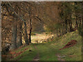
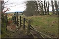
Track below Newby Craigs
by Jim Barton geograph for square NT2637 A track on the east side on the Glensax Burn, not shown on the 1:25,000 map.
|
|
Track from Kitleyknowe
by Jim Barton geograph for square NT1656 A track from Kitleyknowe to a beech wood on the top of the bank of the River North Esk.
|
|
Track to Langlees
by Jim Barton for square NT0238 The track passes Langlees House to meet a minor road from Langlees Farm, thence to Biggar.
Tags:
type:Cross GridX
Farm TrackX
top:Farm, Fishery, Market GardeningX
FarmlandX
top:PathsX
top:Roads, Road TransportX
Trees by a Track
|
|
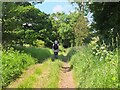
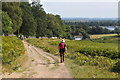
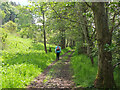
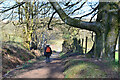
Borders Abbeys Way south of Jedburgh
by Jim Barton geograph for square NT6419 A sunny summer's day on the track through farmland.
Tags:
long distance path:Borders Abbeys WayX
top:Farm, Fishery, Market GardeningX
type:GeographX
top:PathsX
TrackX
Trees by a Track
WalkerX
|
|
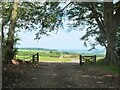
Track to Cropston Reservoir, Bradgate Park
by Jim Barton geograph for square SK5311 The track meets the public road at Hallgates car park.
Tags:
plant:BrackenX
Bradgate ParkX
type:GeographX
top:Lakes, Wetland, BogX
top:Park and Public GardensX
top:PathsX
ReservoirX
top:Roads, Road TransportX
TrackX
Trees by a Track
WalkersX
|
|
Track to Skirling
by Jim Barton geograph for square NT0738 A track from Gallows Knowe to reach the minor road close to the A72.
|
|
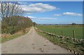
Track towards Allochie Farm
by Stanley Howe geograph for square NO8691 From its junction with the B979, south of Netherley.
Tags:
postcode area:AB39X
Blue Sky White CloudsX
Farm TrackX
top:Farm, Fishery, Market GardeningX
type:GeographX
place:NetherleyX
top:Roads, Road TransportX
subject:TrackX
Trees by a Track
|
|
The Loaning east of Eckford
by Jim Barton geograph for square NT7125 A former drove road and ancient route to Wooden Hill.
Tags:
former:Drove RoadX
type:GeographX
top:PathsX
top:Roads, Road TransportX
TrackX
Track Between HedgesX
Trees by a Track
|
|
Farm track uphill from Thistleybrook burn
by Stanley Howe geograph for square NJ6401 Near Fordie Farm.
Tags:
postcode area:AB31X
Farm TrackX
top:Farm, Fishery, Market GardeningX
type:GeographX
top:Roads, Road TransportX
place:TorphinsX
subject:TrackX
Trees by a Track
UphillX
|
|
Path near Lower Santley
by Dave Croker geograph for square SJ3500 |
|
Former railway by the Tweed
by Jim Barton geograph for square NT2139 The former Caledonian line between Biggar and Peebles, now a pleasant walk... (more)
Tags:
top:Derelict, DisusedX
Former Railway RouteX
type:GeographX
top:PathsX
top:RailwaysX
Trees by a Track
WalkerX
|
|
Edge of Todlaw Wells Plantation
by Jim Barton geograph for square NT6318 The northern edge of the plantation in farmland below Dunion Hill.
Tags:
long distance path:Borders Abbeys WayX
top:Farm, Fishery, Market GardeningX
FarmlandX
type:GeographX
top:PathsX
top:Roads, Road TransportX
TrackX
Trees by a Track
top:Woodland, ForestX
|
|
Path from Moffat
by Jim Barton geograph for square NT0805 A path through farmland south of Gallow Hill.
|
|
Path north of Moffat
by Jim Barton geograph for square NT0805 A path between fields to Heatheryhaugh and the minor road via Archbank to Moffat Well.
|
|
Drove Road above Romannobridge
by Jim Barton geograph for square NT1748 The Drove Road gains height to cross the ridge near Drum Maw and descend to the... (more)
|