|
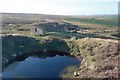
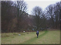
Sil Howe Whinstone Mine
by Mick Garratt
geograph for square NZ8402
|
|
Sil Howe Whinstone Mine
by Mick Garratt
geograph for square NZ8402
|
|
Sil Howe Whinstone Mine
by Mick Garratt
geograph for square NZ8402
|
|
Sil Howe Whinstone Mine
by Mick Garratt
geograph for square NZ8402
|
|
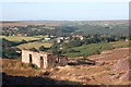
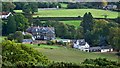
Undercliffe Hall
by Mick Garratt
geograph for square NZ5711
I have posted many times about the whinstone quarry at Cliff Rigg near Great... (more)
|
|
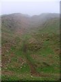
Old Whinstone Quarry
by Mick Garratt
geograph for square NZ8900
At Pike Hill.
A small gulley is evidence of an abandoned whinstone quarry... (more)
|
|
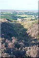
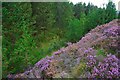
Remains of Whinstone Quarry, Stony Rigg
by Mick Garratt
geograph for square NZ8303
Category: Industrial heritage
Whinstone is a hard volcanic rock used as chippings and cobbles in road... (more)
|
|
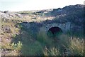
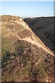
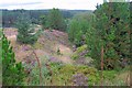
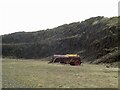
Sil Howe Whinstone Quarry
by Mick Garratt
geograph for square NZ8403
Disused quarry for the extraction of whinstone, part of the Cleveland Dyke.
|
|
Old Whinstone Quarry
by Mick Garratt
geograph for square NZ8800
A small gulley is evidence of an abandoned whinstone quarry that has now almost... (more)
|
|
Highshield Crags and Crag Lough
by Adrian Taylor
for square NY7668
Crag Lough below the whinstone escarpment of Highshield Crags. The prominent... (more)
|
|
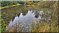
Pond, Sneaton Forest
by Mick Garratt
geograph for square NZ8801
The first time I orienteered in Sneaton the map was called Maybeck, the spruce... (more)
|
|
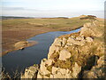
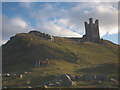
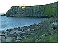
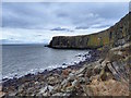
Castle Point, Dunstanburgh
by Alan Murray-Rust
geograph for square NU2522
View showing the full sweep of the whinstone (dolerite) cliffs.
|
|
Footpath below Spindlestone Heughs
by Karl and Ali
geograph for square NU1533
The 'heughs' are a line of dolerite (whinstone) cliffs visible through... (more)
|
|
Grassy sward below Dunstanburgh Castle
by Karl and Ali
geograph for square NU2522
A pleasant spot to take a break among the whinstone boulders that have tumbled... (more)
|
|
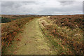
Former tramway, Goathland
by Pauline E
geograph for square NZ8301
Whinstone ore, to be used as roadstone, was carried across the moors by a narrow... (more)
|
|
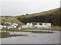
Quarry, Lathalmond Hill
by Richard Webb
geograph for square NT0892
Abandoned bales of plastic meant for recycling.
|
|
Quarry, Lathalmond Hill
by Richard Webb
geograph for square NT0892
|
|
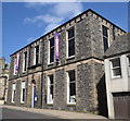
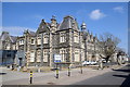
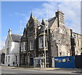
Banff library and museum
by Bill Harrison
for square NJ6863
The C-listing (LB22024):... (more)
|
|
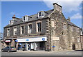
Banff bank I
by Bill Harrison
geograph for square NJ6864
The Banff TSB branch is still open, as of May 2018. The building is C-listed... (more)
|
|
Seafield house, Banff
by Bill Harrison
geograph for square NJ6864
A striking B-listed (LB21942:... (more)
|
|
Banff Methodist church
by Bill Harrison
geograph for square NJ6864
Dating from 1877 and C-listed (LB22093):... (more)
|
|
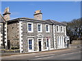
Chalmers' Hospital, Banff
by Bill Harrison
geograph for square NJ6864
The striking old block of the town hospital was erected in 1861 and is B-listed... (more)
|
|
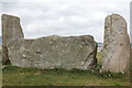
Tomnaverie stone circle: recumbent stone and flankers
by Bill Harrison
geograph for square NJ4803
|
|
Castle Point, Dunstanburgh
by Alan Murray-Rust
geograph for square NU2522
These cliffs formed a natural defence on this side of the castle precinct.
|
|
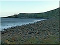
Gull Crag
by Mick Garratt
geograph for square NU2522
Cliffs of volcanic dolerite on which the castle stands.
|
|
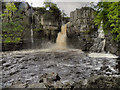
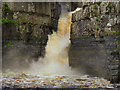
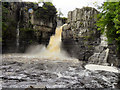
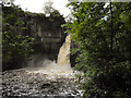
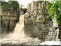
High Force, River Tees
by David Dixon
geograph for square NY8828
|
|
High Force Waterfall, River Tees
by David Dixon
geograph for square NY8828
|
|
High Force Waterfall, River Tees
by David Dixon
geograph for square NY8828
|
|
River Tees, High Force
by David Dixon
geograph for square NY8828
|
|
High Force
by David Dixon
geograph for square NY8828
|
|
Macduff town hall, 17 Shore Street
by Bill Harrison
geograph for square NJ7064
The Scottish baronial town hall facing the harbour was designed by Aberdeen... (more)
|
|
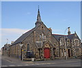
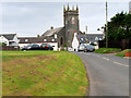
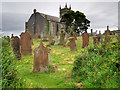
Stoneykirk, St Stephen's
by David Dixon
geograph for square NX0853
The village of Stoneykirk developed around (and took its name from) its parish... (more)
|
|
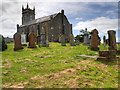
Stoneykirk Parish Church (disused)
by David Dixon
geograph for square NX0853
The village of Stoneykirk developed around (and took its name from) its parish... (more)
|
|
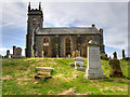
Disused Parish Church at Stoneykirk
by David Dixon
geograph for square NX0853
The village of Stoneykirk developed around (and took its name from) its parish... (more)
|
|
Former Stoneykirk Parish Church
by David Dixon
geograph for square NX0853
The village of Stoneykirk developed around (and took its name from) its parish... (more)
|